Weather Blog Post
Last Updated: Aug 28, 2020 3:21 PM
What you need to know.
.
Key Points
- The remnants of Hurricane Laura will pass through our region Friday and Saturday.
- Strong and gusty winds will accompany this system.
- Locally heavy rain is likely across our region. Some counties will receive more than three inches.
- Short-lived tornadoes will be possible Friday/Friday night. I will monitor Saturday AM.
.
Call to action.
Monitor updated weather forecasts.
Make sure you are using the Weather Talk app. Download it from the app store. It is under Weather Talk.
TURN ON YOUR BEAU DODSON WEATHER TALK APP. Make sure it is on. Make sure you have not accidentally logged out of the app.
The app is for subscribers (please log into your account and make sure your payment has been updated. We have a large number of declined cards and PayPal payments.
Subscribe at www.weathertalk.com/welcome then go to your app store and search for WeatherTalk. Apple users click here. Android users click here
.
Friday, August 28, 2020
The severe risk and flood risk is now over.
.
August 28, 2020
1:18 PM
Henderson, Daviess, and McLean Counties.
A line of thunderstorms is approaching from the south and southwest. Over the past hour these storms have intensified.
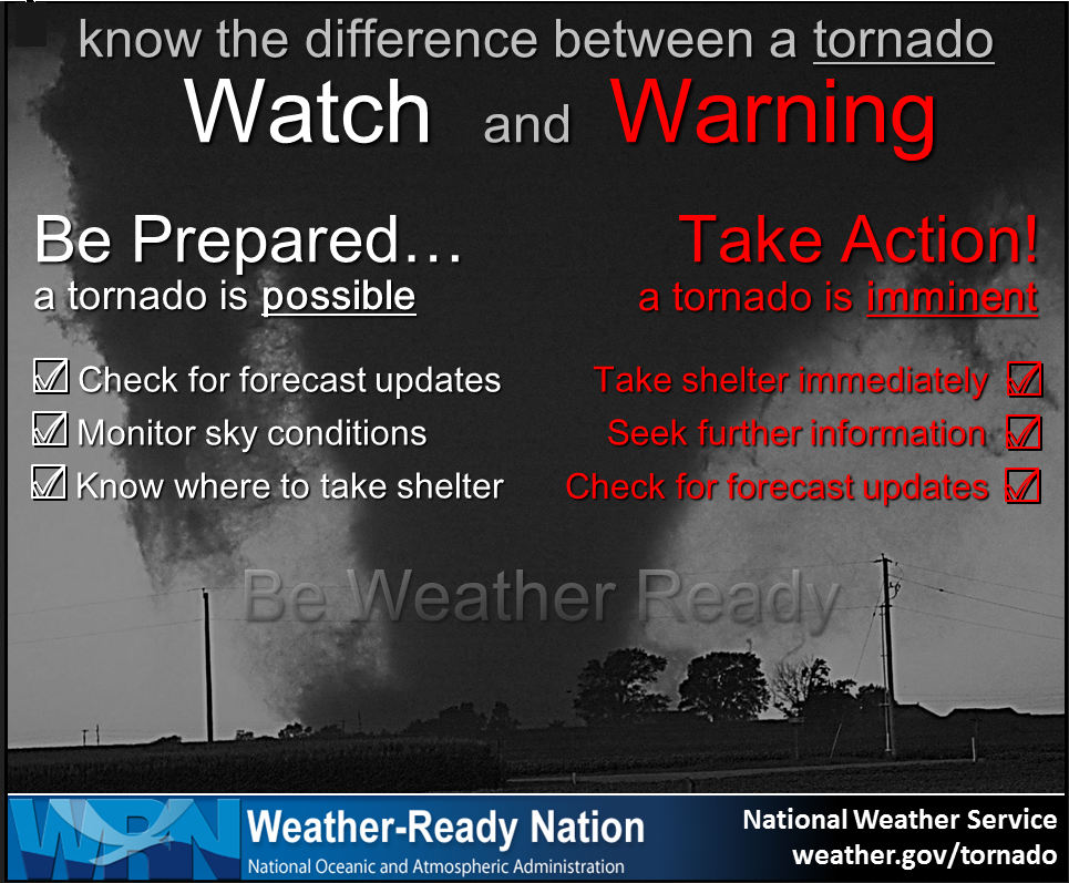
There is a tornado watch in effect until this line passes. Remember, a watch simply means to monitor updates.
A warning means to seek shelter.
The storms may produce strong and gusty wind. There is low chance of a short-lived tornado, as well.
If you feel threatened by storms then seek shelter until they pass.
.
Tornado Watch for Daviess, McLean, Muhlenberg, Todd [KY] till 7:00 PM CDT


.
August 28, 2020
12:50 PM
The severe weather threat appears to be over for southern Illinois, southeast Missouri, northwest Tennessee, and the following counties in western Kentucky.
Ballard, Carlisle, Hickman, Fulton, McCracken, Livingston, Graves, Marshall, Crittenden, Lyon, Trigg, Caldwell, and Calloway.
There is a chance that a few showers and thunderstorms will redevelop this afternoon, behind this ongoing main band of precipitation that remains on radar.
I will keep an eye on those. It appears the risk of anything severe with those would be small.
Gusty winds are possible today as Laura pulls through and away from the region.
Rain totals, thus far, have ranged from 2.5" in southeast Missouri to 0.05" to 1.5" elsewhere.
.
August 28th
9:26 AM
Calloway and Henry Counties.
Radar shows a line of showers and thunderstorms (although there may not be much lightning) moving through Weakley and Graves County.
The line is shifting eastward with time.
There are several areas of rotation associated with this line.
These little areas of rotation can change in strength quite quickly. Short-lived tornadoes are possible today because of the remnants of Hurricane Laura.
Be alert for rapidly changing weather conditions as this line of showers/storms continues to move east and northward.
The entire line is shifting east with time. Individual cells are moving northward.
.
August 28th
9:22 AM
Update for Graves and Weakley Counties.
Radar shows a line of showers and thunderstorms (although there may not be much lightning) moving through Weakley and Graves County.
There are several areas of rotation associated with this line. A stronger area of rotation recently moved out of Weakley County into southern Graves County, Kentucky. The rotation has become a bit more broad over the last two minutes. That means the rotation has weakened some.
These little areas of rotation can change in strength quite quickly.
Be alert for rapidly changing weather conditions as this line of showers/storms continues to move northward. The entire line is shifting east with time. Individual cells are moving northward.
.
August 28, 2020
8:15 AM
Mississippi, Carlisle, Hickman, and Fulton Counties.
The severe thunderstorm warning has now expired. Showers and thunderstorms (perhaps not much lightning with these) will continue to stream northward through the area. Stay alert for changing weather conditions in case one of the storms becomes severe.
We do have some spin in the atmosphere today.
Interactive-city-view radars. Clickable watches and warnings.
https://wtalk.co/B3XHASFZ
.
August 28, 2020
7:52 AM
Radar shows an area of rotation near or west of Moscow, KY. That is southwest of Clinton, KY. Oakton is in the path of this storm.
Brief tornadoes cant' be ruled out with this storm.
A severe thunderstorm was moving south to north through Fulton and Hickman Counties. It will push into eastern Mississippi County and Carlisle County over the next 20 minutes.
Seek shelter if threatened by this storm.
Interactive-city-view radars. Clickable watches and warnings.
https://wtalk.co/B3XHASFZ
.


.
Thursday, August 27, 2020
.
August 27, 2020
11:05 PM
Butler and Stoddard Counties.
At 11:05 PM radar showed an area of rotation near White Oak and another one near Deering, Missouri. That is in Dunklin and Pemiscot Counties. These storms continue to move N NW at 60 mph.
Eventually, they will move into Stoddard and Butler Counties. I can't rule out short-lived tornadoes with these storms.
Seek shelter if you feel threatened by this storm.
Radars
Interactive-city-view radars. Clickable watches and warnings.
https://wtalk.co/B3XHASFZ
.
MEG issues Tornado Warning [tornado: RADAR INDICATED, hail: <.75 IN] for Dunklin, Pemiscot [MO] and Clay [AR] till 11:45 PM CDT ...AT 1059 PM CDT, DOPPLER RADAR INDICATED A SEVERE THUNDERSTORM PRODUCING A TORNADO WAS LOCATED NEAR DEERING, OR NEAR STEELE, MOVING NORTH AT 30 MPH.
.
MEG continues Tornado Warning [tornado: RADAR INDICATED, hail: <.75 IN] for Dunklin, Pemiscot [MO] till 11:00 PM CDT ...AT 1054 PM CDT, DOPPLER RADAR INDICATED A SEVERE THUNDERSTORM PRODUCING A TORNADO WAS LOCATED NEAR HOLCOMB, OR 9 MILES NORTHEAST OF KENNETT, MOVING NORTH AT 60 MPH.
.
August 27, 2020
10:52 PM
Western New Madrid County
At 10:52 PM radar showed an area of rotation east of Kennett, MO. This area of rotation is moving N NW at 60 mph.
This storm may clip the western part of New Madrid County.
Seek shelter if you feel threatened by this storm.
Radars and Lightning Data
Interactive-city-view radars. Clickable watches and warnings.
https://wtalk.co/B3XHASFZ
Backup radar site in case the above one is not working.
https://weathertalk.com/morani
Regional Radar
https://imagery.weathertalk.com/prx/RadarLoop.mp4
Lightning Data (zoom in and out of your local area)
https://wtalk.co/WJ3SN5UZ
.
MEG continues Tornado Warning [tornado: RADAR INDICATED, hail: <.75 IN] for Dunklin, Pemiscot [MO] and Clay [AR] till 11:00 PM CDT ...AT 1039 PM CDT, DOPPLER RADAR INDICATED A SEVERE THUNDERSTORM PRODUCING A TORNADO WAS LOCATED NEAR STEELE, MOVING NORTH AT 60 MPH.
.
MEG issues Tornado Warning [tornado: RADAR INDICATED, hail: <.75 IN] for Dunklin, Pemiscot [MO] and Clay, Mississippi [AR] till 11:00 PM CDT ...AT 1029 PM CDT, DOPPLER RADAR INDICATED A SEVERE THUNDERSTORM PRODUCING A TORNADO WAS LOCATED OVER BLYTHEVILLE, MOVING NORTH AT 60 MPH.
.
August 27, 2020
10:25 PM
Dunklin and Pemiscot Counties.
At 10:24 PM radar showed an area of rotation south of Blytheville, Arkansas. This area of rotation is moving N NW at 40 mph. It will enter the southern part of Pemiscot and Dunklin Counties in about 10 minutes.
Be prepared to seek shelter if you feel threatened by these storms. Do not wait for a tornado warning if you feel threatened seek shelter immediately.
.
August 27, 2020
9:23 PM
Dunklin and Pemiscot Counties.
Thunderstorms are approaching from northeast Arkansas. These storms have a history of producing wind damage. There have also been several tornado warnings associated with these storms.
Be prepared to seek shelter if you feel threatened by these storms. Do not wait for a tornado warning if you feel threatened seek shelter immediately.
Radars and Lightning Data
Interactive-city-view radars. Clickable watches and warnings.
https://wtalk.co/B3XHASFZ
Backup radar site in case the above one is not working.
https://weathertalk.com/morani
Regional Radar
https://imagery.weathertalk.com/prx/RadarLoop.mp4
Lightning Data (zoom in and out of your local area)
https://wtalk.co/WJ3SN5UZ
.
Tornado watch extended into the Bootheel.
MEG extends area+time of Tornado Watch for Dunklin, Pemiscot [MO] and Clay, Greene [AR] till 11:00 PM CDT
.
August 27, 2020
9 PM Severe weather update.
Tropical storm Laura is moving quite a bit faster than anticipated.
The main rain band will move into the Missouri Bootheel and northwest Tennessee over the next few hours.
The system will continue to move north and northeast overnight into the morning hours.
This likely means quite a bit of rain will overspread southeast Missouri and northwest Tennessee tonight. Then eventually into southern Illinois and far western Kentucky.
Model guidance indicates a line of showers and thunderstorms early tomorrow morning 6 AM to 12 PM will push across southeast Missouri, far southern Illinois, western Kentucky, and northwest Tennessee.
After that, additional scattered showers and thunderstorms will develop over the entire region. This will last into Friday afternoon and evening.
There will be a WIDE range of rain totals.
The main band moving into the Missouri Bootheel and northwest Tennessee could easily produce one to three inches of rain tonight and early tomorrow morning.
The lower rain totals will be over the northern half of southeast Missouri and the northern half of southern Illinois.
The scattered nature of tomorrow's showers and thunderstorms will mean rain totals ranging from 0.40" to 2.50". Locally heavier totals are likely where repeated thunderstorms move over the same area.
There will also be a threat of damaging wind gusts with thunderstorms and short-lived tornadoes.
Radars and Lightning Data
Interactive-city-view radars. Clickable watches and warnings.
https://wtalk.co/B3XHASFZ
Backup radar site in case the above one is not working.
https://weathertalk.com/morani
Regional Radar
https://imagery.weathertalk.com/prx/RadarLoop.mp4
Lightning Data (zoom in and out of your local area)
https://wtalk.co/WJ3SN5UZ
.
August 27, 2020
8:45 PM
Butler, New Madrid, Stoddard, Dunklin, Pemiscot, and Lake Counties.
I am watching thunderstorms in northeast Arkansas that have a long history of tornado warnings.
This is the northeast portion of tropical storm Laura. These showers and thunderstorms will continue to rotate into western Tennessee and the Missouri Bootheel.
I can't rule out a brief tornado tonight. Torrential rain will also fall under the main band of showers/storms.
Tropical tornadoes tend to be brief. Typically lasting one to five minutes. This makes it difficult to issue tornado warnings. By the time a warning is issued the tornado is gone.
If you feel threatened by severe weather then seek shelter.
Interactive-city-view radars. Clickable watches and warnings.
https://wtalk.co/B3XHASFZ
.

ESOSCALE DISCUSSION 1603
NWS STORM PREDICTION CENTER NORMAN OK
0829 PM CDT THU AUG 27 2020

AREAS AFFECTED...NORTHEAST ARKANSAS...WESTERN TENNESSEE...MISSOURI
BOOTHEEL

CONCERNING...TORNADO WATCH 458...

VALID 280129Z - 280330Z

THE SEVERE WEATHER THREAT FOR TORNADO WATCH 458 CONTINUES.

SUMMARY...THE RISK FOR AN ISOLATED TORNADO MAY PERSIST FOR A FEW
MORE HOURS ACROSS A SMALL PART OF NORTHEAST ARKANSAS, WESTERN
TENNESSEE, NORTHERN MISSISSIPPI, AND THE MISSOURI BOOTHEEL.

DISCUSSION...A LONG-LIVED ARCING BAND OF STORMS WITH PERIODIC AREAS
OF ROTATION CONTINUES TO EXPAND NORTH/NORTHEASTWARD AWAY FROM THE
CENTER OF LAURA. PRESSURE FALLS ARE NOTED AHEAD OF THE LINE, ALONG
WITH 0-1 SRH NOW DOWN INTO THE 200-300 M2/S2 RANGE. THE AIR MASS
REMAIN VERY MOIST, AND SUFFICIENTLY UNSTABLE TO SUPPORT ISOLATED
SEVERE STORMS AND CAPABLE OF STRONG WIND GUSTS AND BRIEF TORNADOES.

THE BOUNDARY LAYER WILL CONTINUE TO GRADUALLY COOL THIS EVENING,
WHICH WILL REDUCE BUOYANCY OVERALL. IN THE NEAR TERM, THE GREATEST
RELATIVE RISK APPEARS TO BE FROM LAWRENCE COUNTY AR SOUTHEASTWARD
INTO NORTHERN MS.

..JEWELL.. 08/28/2020
.
August 27, 2020
8:06 PM
Marshall, Southern Livingston, and Lyon Counties.
Storms continue to weaken as the move northward. The heaviest storm has now moved into southern Livingston County. Radar no longer shows damaging wind gusts. It does show winds in the 30 to 40 mph range.
Overall, the wind damage potential is now lower. There could still be isolated stronger gusts.
Interactive-city-view radars. Clickable watches and warnings.
https://wtalk.co/B3XHASFZ
.
August 27, 2020
8:02 PM
Storms in Graves County are beginning to weaken. The highest winds were west of Mayfield. The winds have come down quite a bit. Earlier we had 55+ wind signatures. Now we have 30 to 40 mph gusts showing up.
Overall the storm is weakening.
Interactive-city-view radars. Clickable watches and warnings.
https://wtalk.co/B3XHASFZ
.
8/27/20 7:48 PM
Graves County.
Radar has shows high winds near Sedalia and about 5 miles east and west of there. Radar shows wind gusts above 55 mph. These winds may cause tree damage.
The storm is moving N NW at 40 mph. This wind has held together quite well over the past thirty minutes. At this time, it is not weakening.
Some wind damage is likely with the strongest portion of the storm.
Interactive-city-view radars. Clickable watches and warnings.
https://wtalk.co/B3XHASFZ
.
8/27/20 7:41 PM
Southeast Lyon, Marshall, and Calloway County storm update.
Radar has shown a decrease in winds over the past 5 minutes. The strongest winds have moved out of Calloway County so your damaging wind concerns appear to be over.
Radar shows 40 to 45 mph wind gusts southeast of Benton, Kentucky. The areal coverage of the wind has decreased.
This storm may still produce wind gusts of 40 to 50 mph over the next 10 to 15 minutes as it moves N NW at 40 mph.
Southeast Lyon County, it appears your main concern will be some brief gusty winds.
Interactive-city-view radars. Clickable watches and warnings.
https://wtalk.co/B3XHASFZ
.
.
https://wtalk.co/B3XHASFZ
https://wtalk.co/B3XHASFZ
.
.
.
Updated at 11 AM.
Thursday, August 27, 2020.
Hurricane Laura Update.
Please see the graphics on the severe weather blog (see link below).
Main concerns:
Rain will move into southeast Missouri late tonight. There may be showers and thunderstorms this afternoon into the evening, as well.
The rain from Laura will overspread the region Friday morning and will last into the afternoon and evening hours.
The rain will move out Friday night. The atmosphere will remain unstable Saturday. Thus, some additional thunderstorms will be possible.
Laura will bring locally heavy rain. It appears a general one to three inches of rain will fall across far southeast Missouri, extreme southern Illinois, western Kentucky, and northwest Tennessee. There could be locally higher rain totals. Keep that in mind.
There will be a sharp gradient from north to south as far as rain totals. The Mt Vernon, Illinois, area may receive less than 0.50". Meanwhile, extreme Illinois, western Kentucky, the Missouri Bootheel, and northwest Tennessee will receive the higher totals.
A flash flood watch covers portions of the region. See graphics on the severe weather blog.
Gusty wind will develop tonight and last into Friday night. Generally, winds of 15 to 35 mph are anticipated with gusts above 40 mph possible.
There may be gusty wind on Saturday, but confidence in that is lower.
In addition to the above, a few of the showers and thunderstorms could produce short-lived tornadoes and damaging wind. The main concern will be late Friday morning into Friday evening.
Generally, tropical systems don't produce a lot of lightning. You can even have a short-lived tornado without lightning.
A tornado watch may need to be issued for portions of the region. Remember, a watch means to monitor updates. A WARNING means to seek shelter.
Hurricane tornadoes usually only last a few minutes. Thus, they are difficult to issue warnings on. You don't need a warning to seek shelter.
THE LIVE SEVERE WEATHER BLOG HAS BEEN ACTIVATED.
Graphics and forecast discussion.
Link https://wtalk.co/AB6AUKWQ
Today's Facebook Q&A Thread
Link https://wtalk.co/YVJKR6G8
Radars and Lightning Data
Interactive-city-view radars. Clickable watches and warnings.
https://wtalk.co/B3XHASFZ
Backup radar site in case the above one is not working.
https://weathertalk.com/morani
Regional Radar
https://imagery.weathertalk.com/prx/RadarLoop.mp4
Lightning Data (zoom in and out of your local area)
https://wtalk.co/WJ3SN5UZ
Future-cast radar from two models.


.
Updated at 8 AM
Today through September 3rd
The live severe weather blog has been activated.
Link https://wtalk.co/AB6AUKWQ
I am monitoring the risk of tornadoes Friday into Friday night. The remnants of Laura will pass through our region during that time-period. Dying hurricanes can produce tornadoes well inland. These are usually short lived and difficult to issue warnings on. They last a few seconds to minutes.
You do not have to have lightning and thunder to have a tornado during a tropical event.
Thunderstorms over the coming days could also produce strong and gusty wind.
Today's outlook (below).
Light green is where thunderstorms may occur but should be below severe levels.
Dark green is a level one risk. Yellow is a level two risk. Orange is a level three (enhanced) risk. Red is a level four (moderate) risk. Pink is a level five (high) risk.
One is the lowest risk. Five is the highest risk.
A severe storm is one that produces 58 mph wind or higher, quarter size hail, and/or a tornado.
The tan states are simply a region that SPC outlined on this particular map. Just ignore that.

The black outline is our local area.

.
Tomorrow's severe weather outlook.

.

.
The images below are from the WPC. Their totals are a bit lower than our current forecast. I wanted to show you the comparison.
24-hour precipitation outlook.
.
 .
.
48-hour precipitation outlook.
.
.
72-hour precipitation outlook.
.
![]()

![]()
..
Weather advice:
Updated August 27, 2020
The live severe weather blog has been activated.
Link https://wtalk.co/AB6AUKWQ
The main concern will be monitoring the track of Hurricane Laura. This will bring heavy rain and strong wind into our region Friday into Friday night/Saturday. Wind gusts above 45 mph are likely with this system.
In addition to the above, we can expect locally heavy rain totals in excess of three inches.
Short-lived tornadoes will also be possible Friday and Friday night as the remnants of Laura pass through our region.
Download the Beau Dodson Weather Talk app from the app store. Search for Weather Talk by the Fire Horn. Download it. Install it. It is for subscribers. Not a subscriber? Go to www.weathertalk.com/welcome
.
Weather Discussion
-
- Hot and humid.
- Increasing shower and thunderstorm chances.
- Tracking Hurricane Laura
.
The live severe weather blog has been activated.
Link https://wtalk.co/AB6AUKWQ
An active weather pattern is developing.
I am tracking Hurricane Laura.
AM satellite imagery showers a powerful hurricane in Louisiana and extreme eastern Texas

You can see the clouds are already moving into our area. We are at the top of this image.

.
The latest National Hurricane Center track forecast takes this system over our region later this week.

.
Here is the EC forecast for the track of Laura.
The system will have weakened to a tropical depression by the time it crosses our local area.
The dark green represents the heaviest rain. Six-hour rain totals.
Six hour rain totals ending at 7 AM Friday.

Six hour rain totals from 7 AM to 1 PM

1 PM to 7 PM

7 PM to 1 AM Friday night.

1 AM Saturday to 7 AM Saturday. Again, six-hour rain totals.

.
Thursday and Thursday night:
It will remain warm and muggy Thursday into Thursday night.
A few isolated to widely scattered showers and thunderstorms will be possible Thursday. Many areas will remain dry. Storm coverage is forecast to be lower Thursday.
The remnants of Hurricane Laura will push into our region Thursday night.
We will see rain chances begin to rise over southeast Missouri late Thursday night.
Gusty winds may develop late Thursday night, as well. Mostly in the 15 to 25 mph range.
Severe weather is unlikely Thursday night.
.
Friday into Saturday:
The remnants of Hurricane Laura will push directly across our region Friday into Friday night/Saturday.
There will be several items of interest with this system.
Strong and gusty wind is likely with Laura. You can expect occasional wind gusts above 40 mph Friday/Friday night. Gusty wind on Saturday morning, as well.
Thunderstorms or heavier showers will be able to bring stronger winds down to the surface. It is possible someone picks up a wind gust above 50 mph.
Here is the wind gust field forecast from the EC model.
Strong and gusty winds will develop Friday into Saturday. That will be in response to rapidly falling and rising barometric pressure.
A tight pressure gradient as Laura moves across our region.
Here is the 7 Am to 1 PM Friday wind gust map.

.
Here is the Friday 1 PM to Friday 7 PM wind gust map. You can see gusty wind over our local area.

.
Here is the 7 PM to 1 AM Friday night wind gust map.

.
Again, there remain some questions about just how high winds will reach. Monitor updates.
Thankfully, Laura will be moving at a decent speed as it moves across our region. This will help keep rain totals somewhat lower.
PWAT values will be high. PWAT is a measure of moisture into the entire atmospheric column.
You can see that slug of moisture as Laura passes over our local area.

.
At this time, it appears rain totals of one to three inches will be likely across much of our region.
There could be a higher band closer to the center of Laura's center.
The general rule will be one to three inches. Some less. Some more. As always.
A flash flood watch covers portions of the region. Green is the flash flood watch. That is for Friday into Friday night.

.
At this time, we have the heaviest rain falling across far southeast Missouri, extreme southern Illinois, western Kentucky, and northwest Tennessee.
Again, there can always be higher totals during tropical weather events. If convection were to train over the same area for an extended period of time then rain totals would rise.

.
The WPC/NOAA has issues a low-end risk of excessive rainfall for our region Thursday night.

.
A slight to moderate risk of excessive rainfall Friday and Friday night.
The red zone is the moderate risk. Yellow is slight. Green is a marginal risk.
Red is the area of greatest concern. This simply means flash flooding will be possible.

.
Here is what the Paducah, Kentucky, National Weather Service has put out as far as rain totals.

.
In addition to the above, dying tropical systems can produce short-lived tornadoes.
Tornadoes normally occur in the right front quadrant of hurricanes and the remnants of tropical storms/hurricanes.
We will be in the right front quadrant.

.
The Storm Prediction Center has placed our region in a marginal risk Thursday night for a small portion of the Bootheel.

Tornado risk zone.

.
There is a level one and two risk of severe storms Friday/Friday night.
Yellow is the higher zone. That is the level two.

Here is the tornado risk zone. Brown is a slightly higher chance than the green.
I can't rule out a short-lived tornado.

.
These tornadoes are extremely difficult to issue tornado warnings on. They can occur without lightning and thunder.
They typically last a few seconds to a few minutes. One or two radar sweeps.
It is not uncommon for our region to experience tornadoes from dying tropical systems. Be alert Friday/Friday night and perhaps Saturday morning.
I will be sending out messages via my Weather Talk app.
.
Saturday into Wednesday:
An unsettled pattern will develop over the weekend into next week.
At this time, I have at least low-end chances of showers and thunderstorms each day. Some days with a higher chance than other days.
See the detailed information at the top of the page.
I suspect, as we get closer to each 12-hour time period, that the forecast will need adjustments.
That would happen as I get a better handle on each impulse that will move across the region.
Locally heavy rain will be possible with thunderstorms. Gusty wind, as well.
For now, there is not a strong signal for severe weather. I can't rule out that changing. I will be monitoring.
.
 .
.
Click here if you would like to return to the top of the page.
Again, as a reminder, these are models. They are never 100% accurate. Take the general idea from them.
What should I take from these?
- The general idea and not specifics. Models usually do well with the generalities.
- The time-stamp is located in the upper left corner.
.
What am I looking at?
You are looking at different models. Meteorologists use many different models to forecast the weather. All models are wrong. Some are more wrong than others. Meteorologists have to make a forecast based on the guidance/models.
I show you these so you can see what the different models are showing as far as precipitation. If most of the models agree, then the confidence in the final weather forecast increases.
.
This animation is the Hrrr model.
This animation shows you what radar might look like as the next system pulls through the region. It is a future-cast radar.
Green is rain. Blue is snow. Pink and red represent sleet and freezing rain.
Time-stamp upper left. Click the animation to enlarge it.

.
This animation is the SPC WRF model.
This animation shows you what radar might look like as the next system pulls through the region. It is a future-cast radar.
Green is rain. Blue is snow. Pink and red represent sleet and freezing rain.
Time-stamp upper left. Click the animation to enlarge it.

.
This animation is the 3K American Model.
This animation shows you what radar might look like as the next system pulls through the region. It is a future-cast radar.
Green is rain. Blue is snow. Pink and red represent sleet and freezing rain.
Time-stamp upper left. Click the animation to enlarge it.

.
This next animation is the NAM American Model.
This animation shows you what radar might look like as the system pulls through the region. It is a future-cast radar.
Green is rain. Blue is snow. Pink and red represent sleet and freezing rain.
Time-stamp upper left. Click the animation to enlarge it.

This next animation is the GFS American Model.
This animation shows you what radar might look like as the system pulls through the region. It is a future-cast radar.
Green is rain. Blue is snow. Pink and red represent sleet and freezing rain.
Time-stamp upper left. Click the animation to enlarge it.

.
This next animation is the EC American Model.
This animation shows you what radar might look like as the system pulls through the region. It is a future-cast radar.
Green is rain. Blue is snow. Pink and red represent sleet and freezing rain.
Time-stamp upper left. Click the animation to enlarge it.

....
Previous update.
Wednesday, August 26, 2020.
7:30 AM Update.
An active weather pattern is developing.
I am tracking Hurricane Laura.
AM satellite imagery showers a powerful hurricane in the Gulf of Mexico.
Satellite link (hit refresh once there) Link

.
The latest National Hurricane Center track forecast takes this system over our region later this week.

.
Here is the EC forecast for the track of Laura.
The system will have weakened to a tropical depression by the time it crosses our local area.
The green area if the lowest barometric pressure readings. That is the center of the remnants of Laura.
The area of low pressure will pass directly over our local area. It shows 994 millibars. Your home barometer will have a considerable drop Thursday night into Friday night!

.
The EC actually has Laura strengthening a bit as it moves across our area. The pressure drops to 991 millibars. We will have to monitor that.
If that happens then the risk of strong and gusty winds would increase.

.
Friday into Saturday:
The remnants of Hurricane Laura will push directly across our region Friday into Friday night/Saturday.
There will be several items of interest with this system.
Strong and gusty wind is likely with Laura. You can expect occasional wind gusts above 40 mph Friday/Friday night. Gusty wind on Saturday morning, as well.
Here is the wind gust field forecast from the EC model.
Strong and gusty winds will develop Friday into Saturday. That will be in response to rapidly falling and rising barometric pressure.
A tight pressure gradient as Laura moves across our region.

.
Here is the Saturday 7 AM wind gust map. You can see gusty wind over our local area.

.
Here is the NAM model wind forecast for 7 AM Friday.

.
10 AM Friday

.
1 PM Friday
There remain some questions about just how strong winds will be with Laura. I currently have winds gusting above 40/45 mph.

.
Again, there remain some questions about just how high winds will reach. Monitor updates.
Thankfully, Laura will be moving at a decent speed as it moves across our region. This will help keep rain totals somewhat lower.
PWAT values will be high. PWAT is a measure of moisture into the entire atmospheric column.
You can see that slug of moisture as Laura passes over our local area.

.
At this time, it appears rain totals of one to three inches will be likely across much of our region.
There will be a higher band closer to the center of Laura's center.
A band of three to five inches of rain can not be ruled out.
A flash flood watch will likely be issued for portions of the region.
The location of the heaviest rain will need to be monitored. Any shift in Laura's path will change where the heavier rain totals occur.
At this time, we have the heaviest rain falling across far southeast Missouri, extreme southern Illinois, western Kentucky, and northwest Tennessee.
Here is the EC rainfall forecast. One model of many.
It shows the possibility of some locations picking up more than three inches of rain.
I would not take this at its word. It is unlikely to be exactly right.
Take the general idea from this.
A sharp gradient of rain totals from north to south. Heaviest rains will likely be across far southeast Missouri, extreme southern Illinois, western Kentucky, and northwest Tennessee.

.
The GFS shows a mean rain total of over 2 inches in Paducah, Kentucky. You can see the GFS models range.
Again, the mean is over two inches.

.
The WPC/NOAA has issues a low-end risk of excessive rainfall for our region Thursday night.

.
A slight to moderate risk of excessive rainfall Friday and Friday night.
The red zone is the moderate risk. Yellow is slight. Green is a marginal risk.
Red is the area of greatest concern. This simply means flash flooding will be possible.

.
Here is what the Paducah, Kentucky, National Weather Service has put out as far as rain totals.

.
Here is the EC model rainfall forecast totals.

.
Here is the NAM models rainfall totals forecast.

.
In addition to the above, dying tropical systems can produce short-lived tornadoes.
Tornadoes normally occur in the right front quadrant of hurricanes and the remnants of tropical storms/hurricanes.
We will be in the right front quadrant.
.
The Storm Prediction Center has placed our region in a marginal risk of tornadoes Friday/Friday night.
This may need to be upgraded another level.

.
These tornadoes are extremely difficult to issue tornado warnings on. They can occur without lightning and thunder.
They typically last a few seconds to a few minutes. One or two radar sweeps.
It is not uncommon for our region to experience tornadoes from dying tropical systems. Be alert Friday/Friday night and perhaps Saturday morning.
I will be sending out messages via my Weather Talk app.
Showers and thunderstorms will begin to wind down Saturday morning into Saturday afternoon.
Winds aloft will be quite strong Friday into Friday night/Saturday morning.
You can see that on this animation showing you the winds at the 850 mb level. Several thousand feet aloft.
This will enhance wind shear. Wind shear can lead to a tornado threat.

![]()
.
.
Click here if you would like to return to the top of the page.
Again, as a reminder, these are models. They are never 100% accurate. Take the general idea from them.
What should I take from these?
- The general idea and not specifics. Models usually do well with the generalities.
- The time-stamp is located in the upper left corner.
.
What am I looking at?
You are looking at different models. Meteorologists use many different models to forecast the weather. All models are wrong. Some are more wrong than others. Meteorologists have to make a forecast based on the guidance/models.
I show you these so you can see what the different models are showing as far as precipitation. If most of the models agree, then the confidence in the final weather forecast increases.
.
This animation is the Hrrr model.
This animation shows you what radar might look like as the next system pulls through the region. It is a future-cast radar.
Green is rain. Blue is snow. Pink and red represent sleet and freezing rain.
Time-stamp upper left. Click the animation to enlarge it.

.
This animation is the SPC WRF model.
This animation shows you what radar might look like as the next system pulls through the region. It is a future-cast radar.
Green is rain. Blue is snow. Pink and red represent sleet and freezing rain.
Time-stamp upper left. Click the animation to enlarge it.

.
This animation is the 3K American Model.
This animation shows you what radar might look like as the next system pulls through the region. It is a future-cast radar.
Green is rain. Blue is snow. Pink and red represent sleet and freezing rain.
Time-stamp upper left. Click the animation to enlarge it.

.
This next animation is the NAM American Model.
This animation shows you what radar might look like as the system pulls through the region. It is a future-cast radar.
Green is rain. Blue is snow. Pink and red represent sleet and freezing rain.
Time-stamp upper left. Click the animation to enlarge it.

This next animation is the GFS American Model.
This animation shows you what radar might look like as the system pulls through the region. It is a future-cast radar.
Green is rain. Blue is snow. Pink and red represent sleet and freezing rain.
Time-stamp upper left. Click the animation to enlarge it.

.
This next animation is the EC American Model.
This animation shows you what radar might look like as the system pulls through the region. It is a future-cast radar.
Green is rain. Blue is snow. Pink and red represent sleet and freezing rain.
Time-stamp upper left. Click the animation to enlarge it.
.
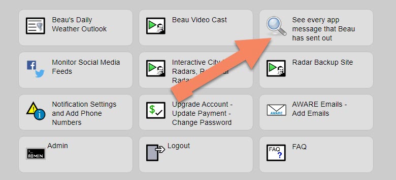
Note: We added a "see all" button on the website. This allows you to see every message that I have sent out (to all my forecast counties).
Here is the link. Click here.
To view the live radars, visit these links.
Radars
Interactive city-view radars
http://weatherobservatory.com/weather-radar.htm
A third backup radar
https://weathertalk.com/morani
Clickable watches and warnings can be viewed on the local city-view interactive radars (link above). Be sure and turn on the warnings above the local radars.
A new regional radar we offer
https://imagery.weathertalk.com/prx/RadarLoop.mp4
Lightning data
https://wtalk.co/7QT7WHKU
.
Storm Prediction Center severe weather outlook.
Here is the latest Storm Prediction Center outlook. Remember, don't pay too much attention to the different colors. Focus on the actual forecast. The forecast is for a few severe thunderstorms.
The black outline is our local area.
Light green is where thunderstorms may occur but should be below severe levels.
Dark green is a level one risk. Yellow is a level two risk. Orange is a level three (enhanced) risk. Red is a level four (moderate) risk. Pink is a level five (high) risk.
One is the lowest risk. Five is the highest risk.
A severe storm is one that produces 58 mph wind or higher, quarter size hail, and/or a tornado.
.
Tomorrow's severe weather outlook.
Not receiving app/text messages?
USE THE APP. ATT and Verizon are slowing or stopping the text messages.
Make sure you have the correct app/text options turned on. Find those under the personal notification settings tab at www.weathertalk.com. Red is off. Green is on.
Subscribers, PLEASE USE THE APP. ATT and Verizon are not reliable during severe weather. They are delaying text messages.
The app is under WeatherTalk in the app store.

Apple users click here

Android users click here
.


Live lightning data: Click here.