Weather Blog Post
Last Updated: Jul 07, 2019 8:59 PM

Click one of the links below to take you directly to each section.
- Storm tracking tools. Radars, lightning, satellite. (I moved this to the bottom)
- Go to today's forecast
- Go to the graphic-cast
- Go to the severe weather outlook
- Go to the weather forecast discussion
- Go to the model future-cast radars
- Go to videos
- Go to weeks one, two, three, and four temperature and precipitation graphics
- Spring and summer outlooks. Here are the latest graphics.
- Go to Weatherbrains
- View some of our charity work. Your subscription dollars help support these causes.
Do you have questions or suggestions? If so, please email me. Beaudodson@usawx.com
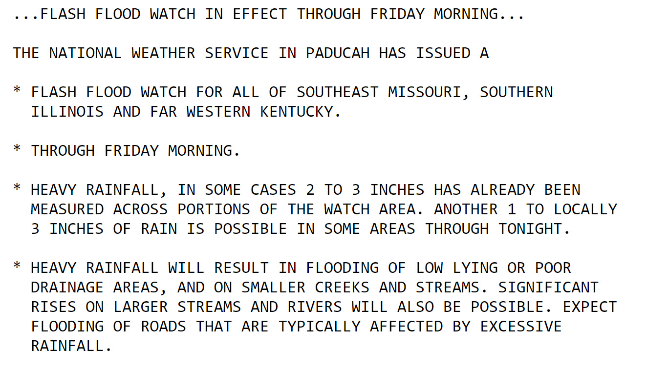
Severe Weather is likely this afternoon and tonight.
.
LIVE SEVERE WEATHER UPDATES.
.
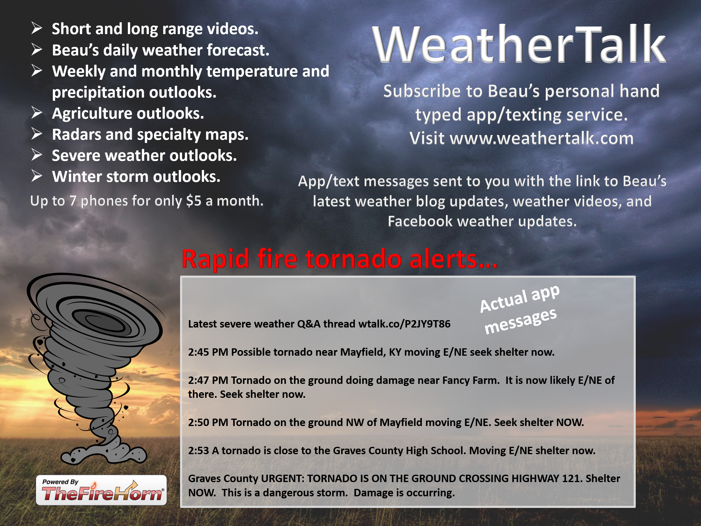
To subscribe to these you can visit www.weathertalk.com/welcome
.
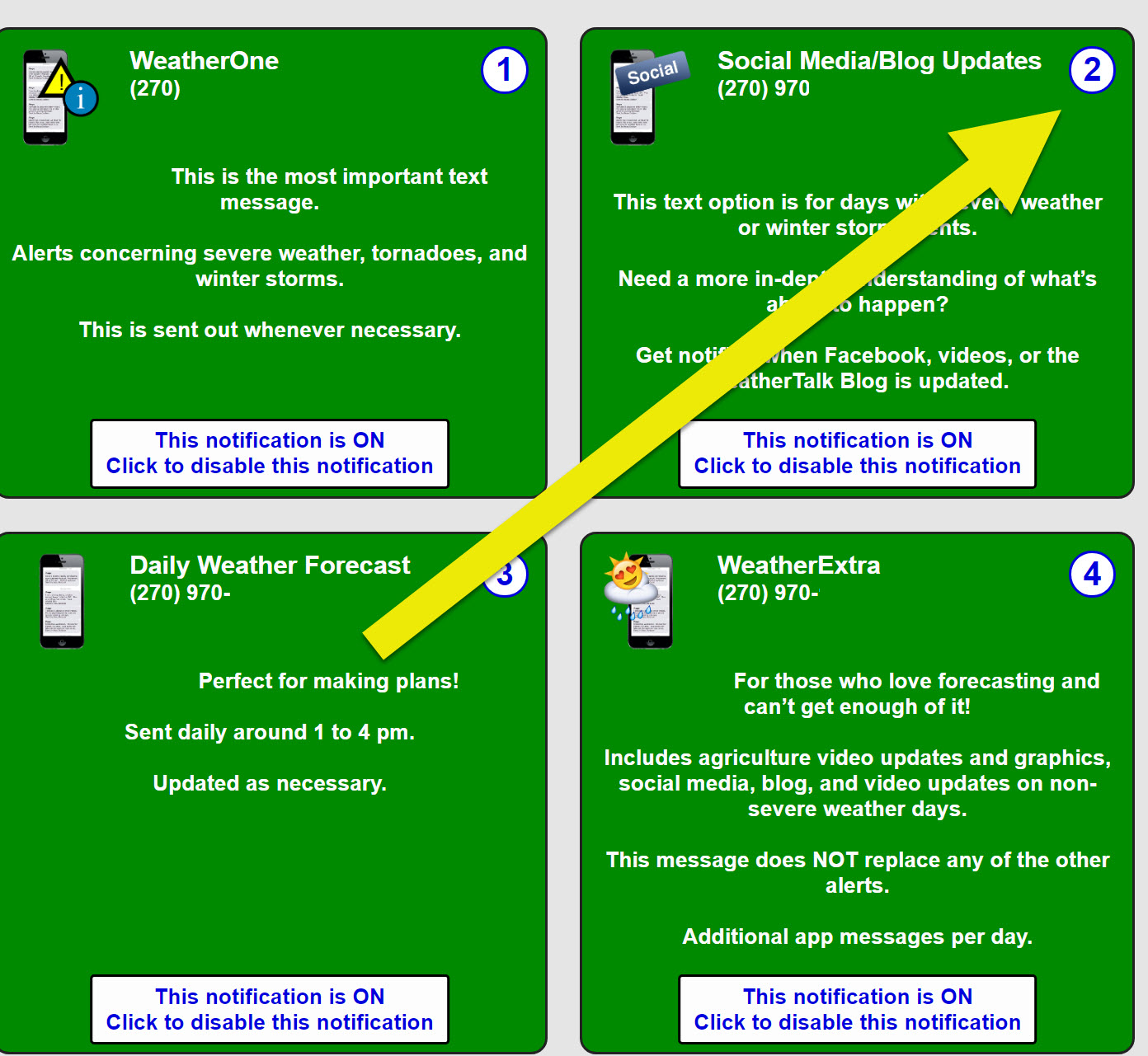
Once you subscribe you will need to turn on WeatherOne under the personal notification settings tab. That is the one for tornadoes, severe storms, ice storms, and winter storms.
Then, turn on the app/text option number two. That is the one for social media on severe weather days. I will send you the link to these live threads before a severe weather event.
.
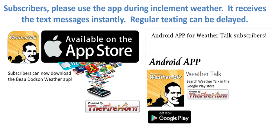
Subscribers, PLEASE USE THE APP. We can not trust ATT and Verizon to send out texts. They are delaying or stopping them.
It is under Beau Dodson Weather in the app store.

Apple users click here

Android users click here
.
Click image to enlarge.

.
.
LINK TO THE LIVE FACEBOOK SEVERE WEATHER THREAD LINK
May 3, 2019
End of this event. Thank you for your photos and storm reports.
.
May 2, 2019
11:56 PM
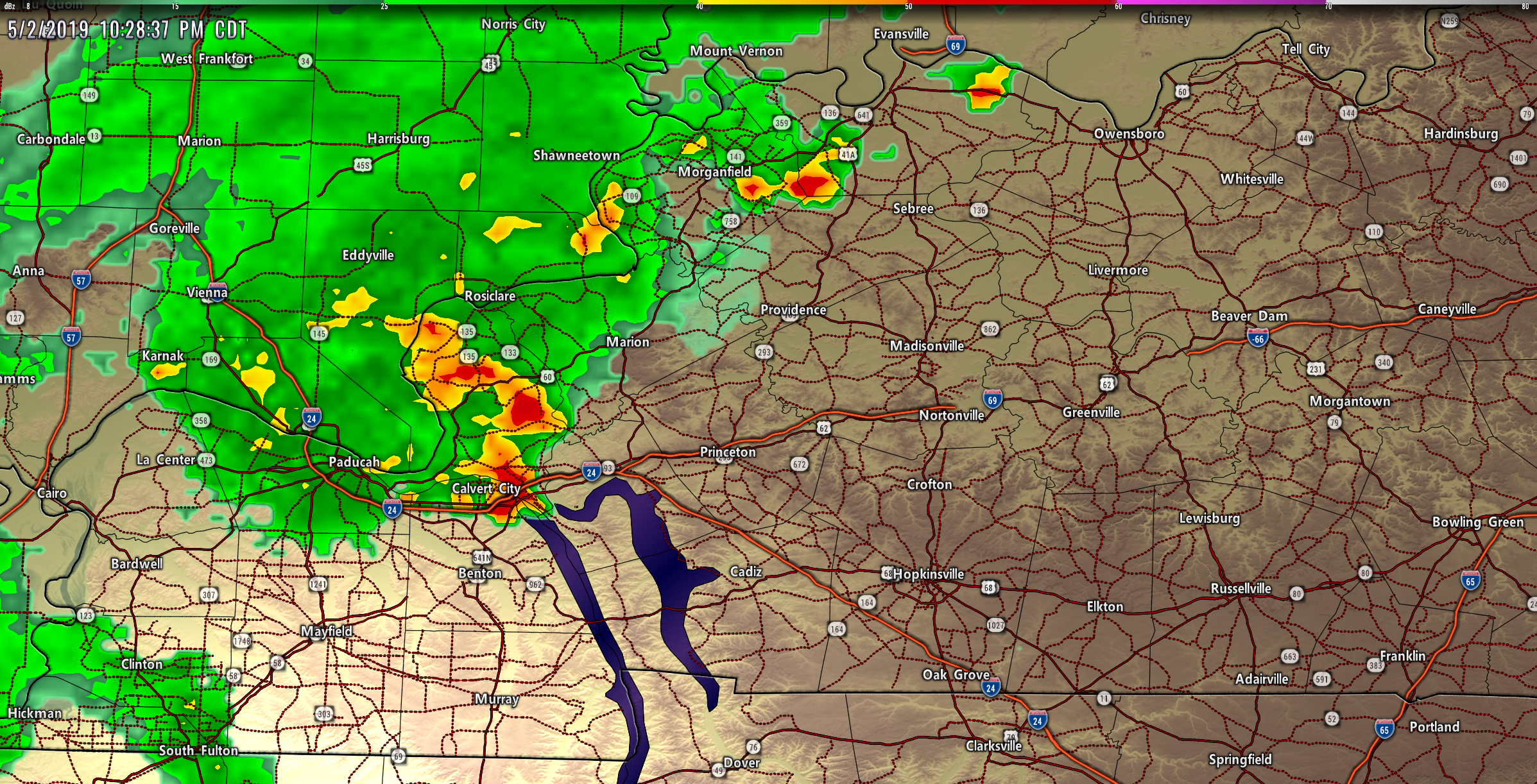
Union & Webster Counties in western Kentucky. The rotation has weakened. The storm is moving NE. Believe the threat is over for now. The storm will exit counties in about 20 more minutes.
I am tracking rotation south or Bordley, KY moving NE along the Union & Webster County line.
Shelter till the storm passes.
Storms are moving NE. This storm could be severe as it is entering Webster County and southeast Union County, KY.
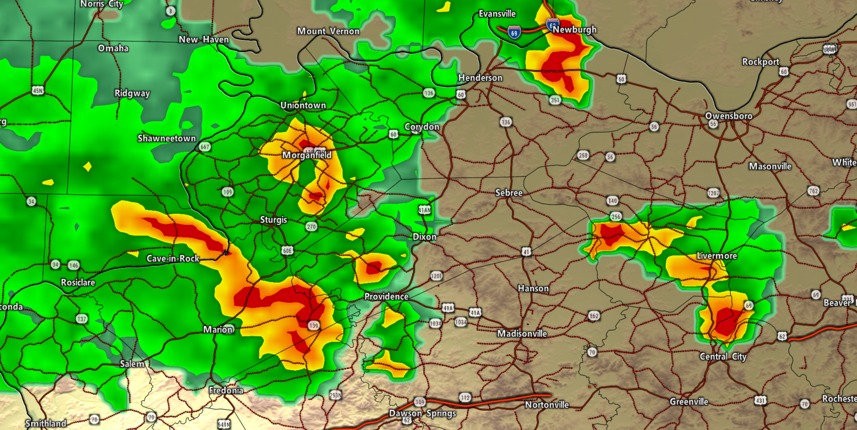
NE Crittenden and Webster and eastern Union Counties. Storm with high winds and some rotation is moving NE. Be alert. The storm is about to exit Crittenden County.
Caldwell and Crittenden Counties. Storms moving through right now could have pea size hail and 45 mph wind gusts.
Video
Video
.
Video

Significant weather advisories are a step below a severe thunderstorm warning.
Lyon County. Storm moving in from the SW with strong winds and hail. Mostly Luka, Suwanee, Kuttawa area. If it remains strong then it would move NE of there, as well.
3D view lower right. That is hail in the thunderstorm. That hail is dropping out of the storm.
There are also strong winds with these storms. North Marshall, part of Livingston, and western Lyon Counties.
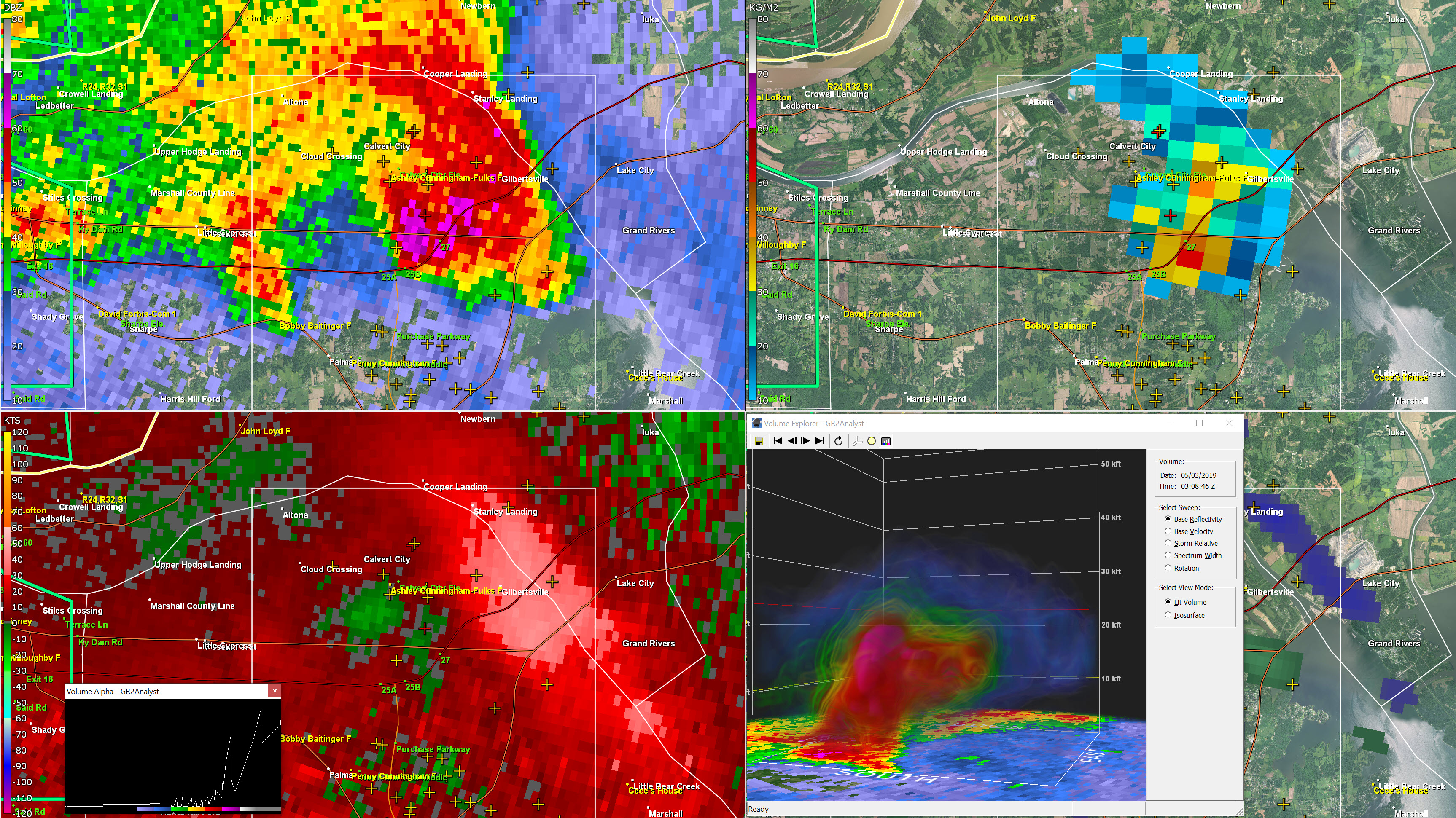
Livingston & Northern Marshall. Storm with hail is moving N NE out of north Marshall. The storm could also produce high winds.
Northern Marshall County. Hail core is likely producing dime to nickel size hail. Could be heavy in spots.
Dime size hail likely in northern Marshall County. Moving N NE 20 mph.
Livingston County. Heavy hail being reported in south part of the county near Smithland and Heater. moving N 20 MPH
Here is a satellite animation showing you today's storms.
Notice they come out of Oklahoma and Texas. The system then moves into Arkansas and eventually into our area.

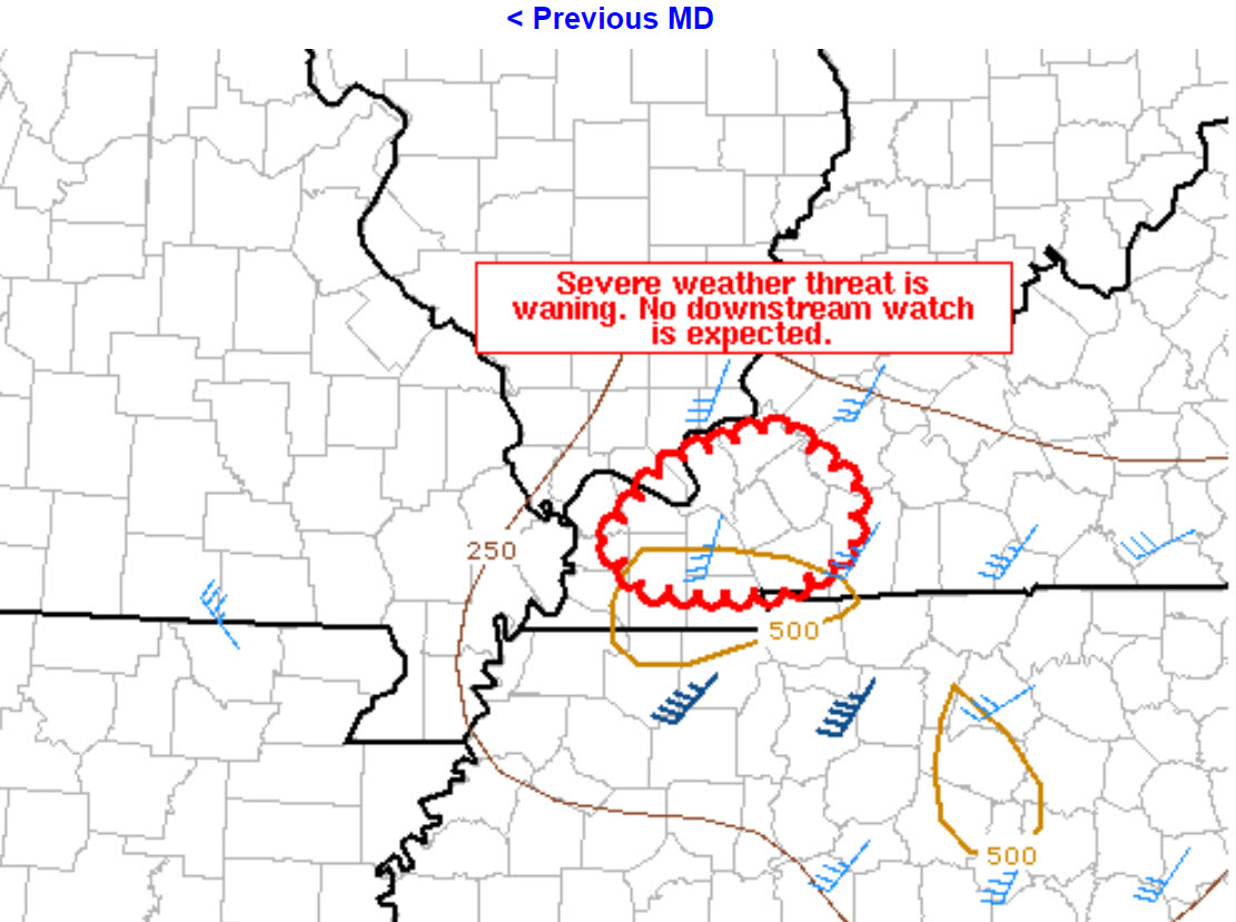
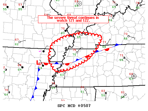
The severe weather threat for Tornado Watch 122 continues.

   SUMMARY...The severe weather threat is waning. A downstream tornado
   watch is not expected.

   DISCUSSION...Convection continues ahead of an MCV which is now
   located near the Mississippi River in far eastern Arkansas. While
   storms are expected to persist through the overnight hours as the
   MCV moves east-northeast, limited buoyancy should limit the overall
   severe threat. No downstream tornado watch is expected.
Livingston and Marshall. Spotty storms moving through could produce isolated high winds and small hail. Tornado risk is low, but not zero. Monitor updates.
Ballard, McCracken, Carlisle, Graves I am tracking storms in your counties. Occasionally, they have small circulations forming. Small hail. Monitor updates.
We are now moving towards a rain/heavy rain event. Severe risk is starting to wane. Some gusty winds still poss in the most intense storms. Monitor.
Rain/heavy rain event developing as this thunderstorm complex rotates through the area.
Severe weather risk is waning.
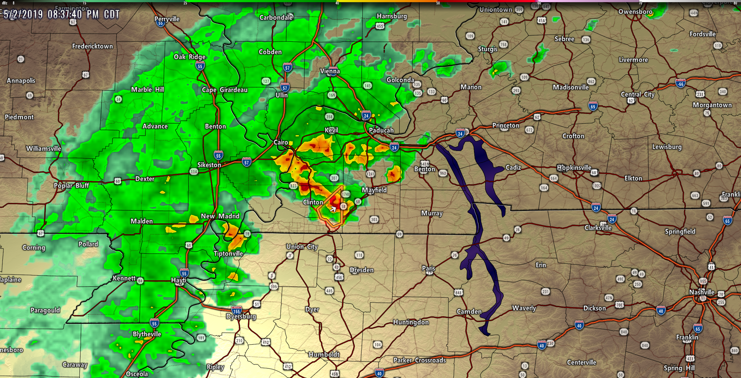
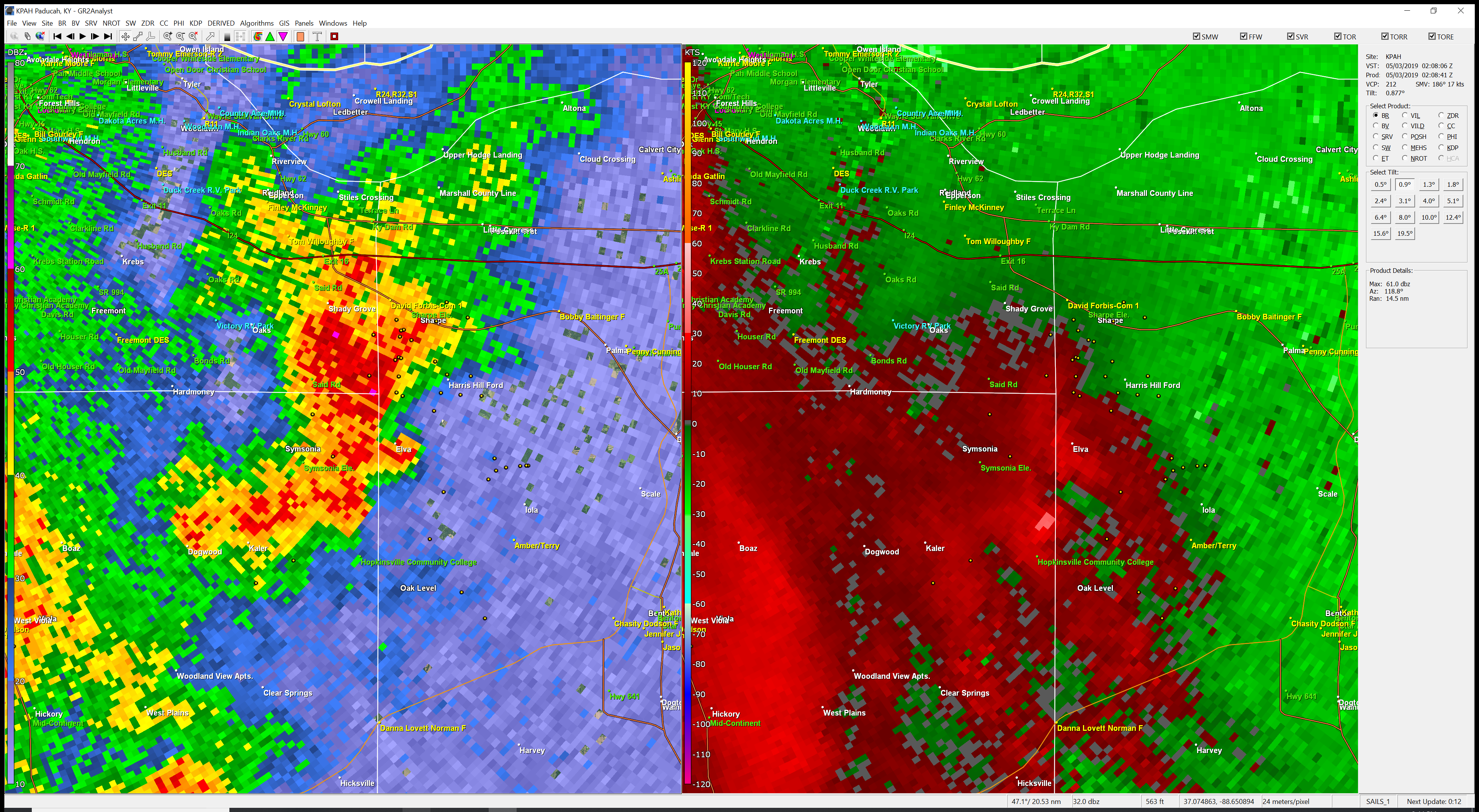
Storms are starting to weaken. Hail is still poss mainly Hickman County for now. The severe risk is likely winding down.
The right side is the hail core.
Obion your storm is weakening and falling apart. Stay aware until it dissipates.
Radar shows large hail NE of Cayce, KY. Fulton County. Moving N NE golfball size hail is possible with this storm.
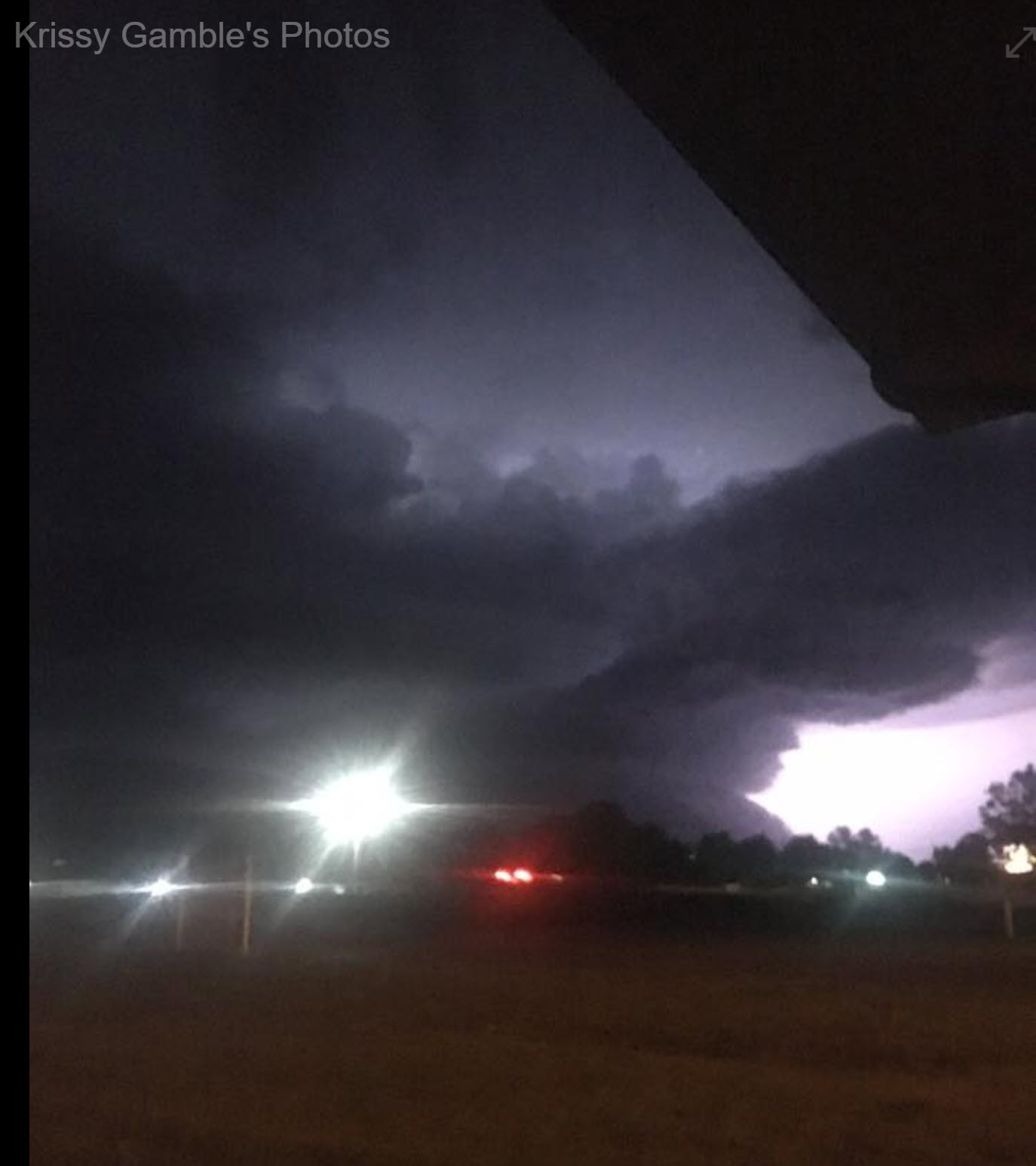
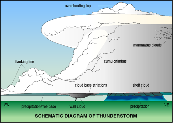
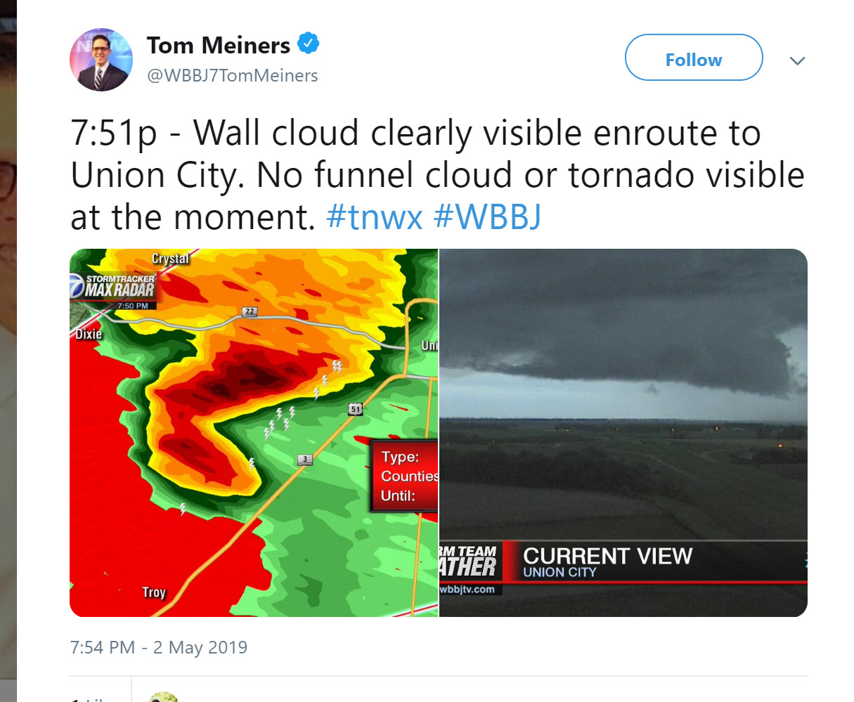
Photos from near Union City show a wall cloud but no tornado at the time of the photo. Be alert a wall cloud comes before a tornado forms.
East Pemiscot, SE New Madrid, Lake Counties be aware storm moving through your area could have hail and high winds. Some rotation so be alert.
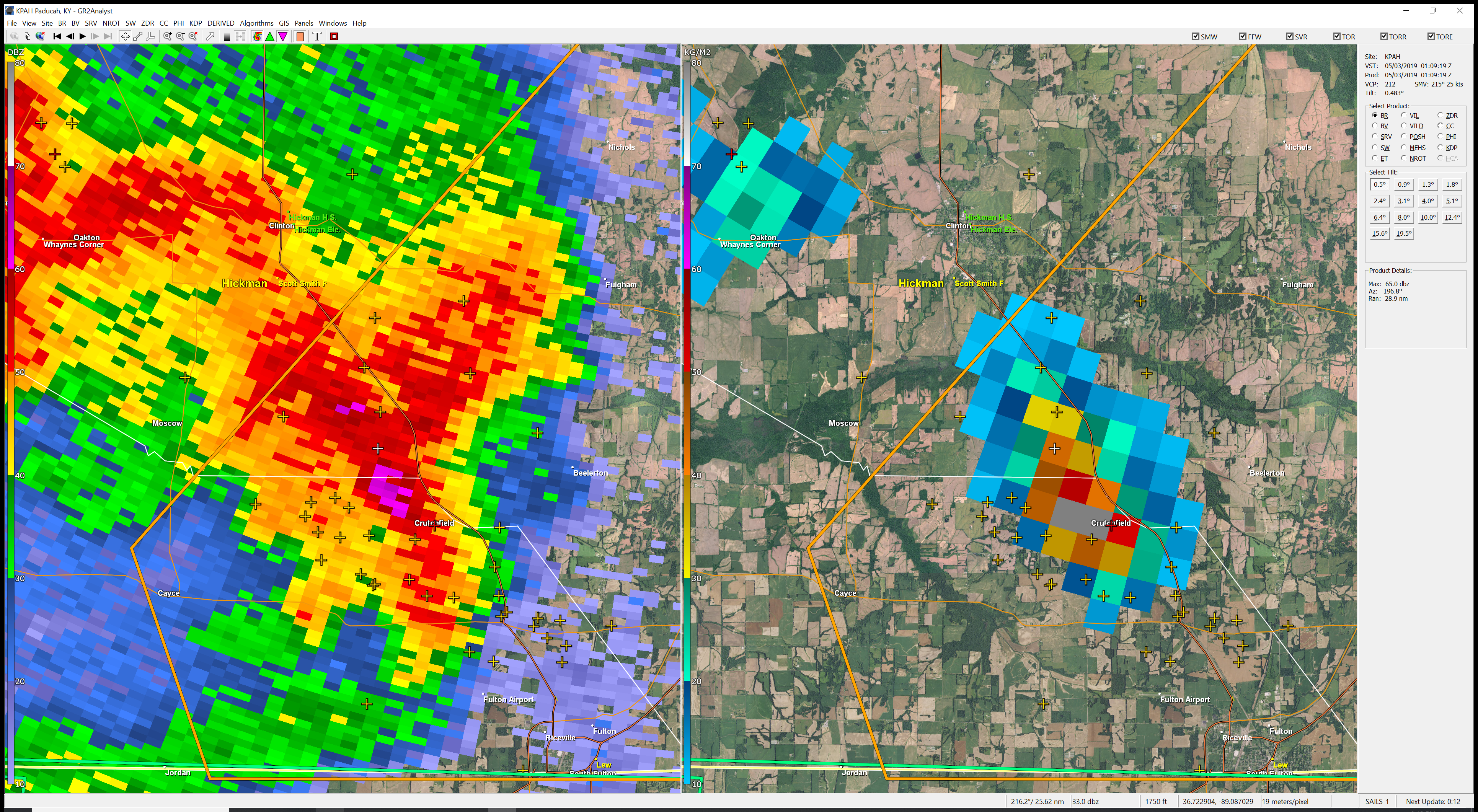
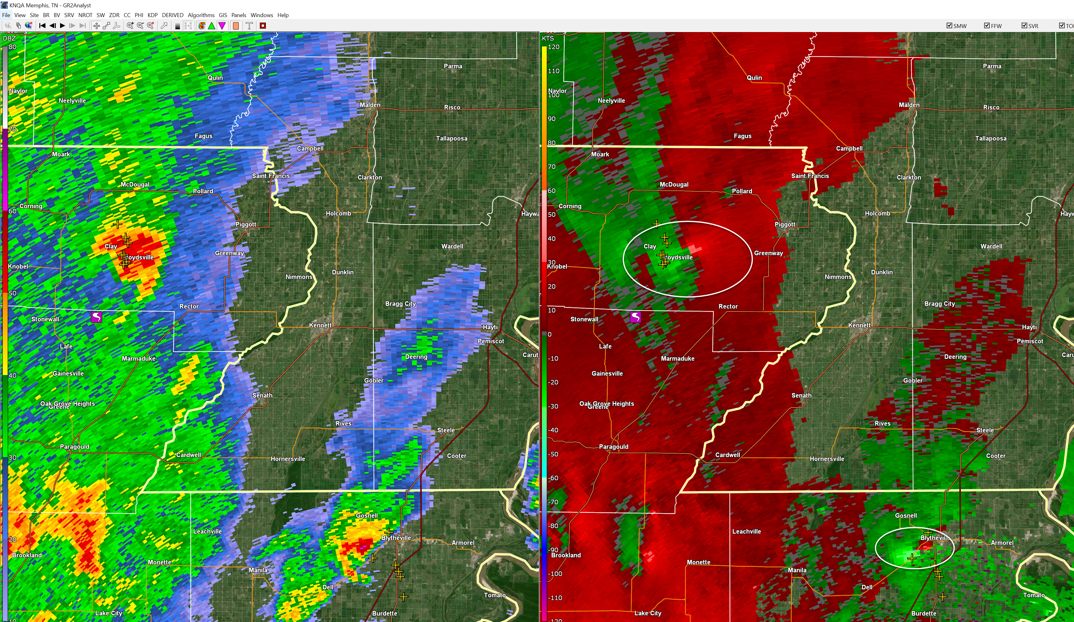
Rotation stronger near Cayce, KY in Fulton County moving N NE 15. Shelter as storm approaches.
Obion. Tracking rotation SW of Union City. As storm approaches seek shelter.
Update Most intense part of storm is SW of Cayce, KY in Fulton County moving N NE 15. Hail likely. Weak rotation.
I am tracking a circulation near Troy TN moving N NE 15. In and near this area seek shelter.
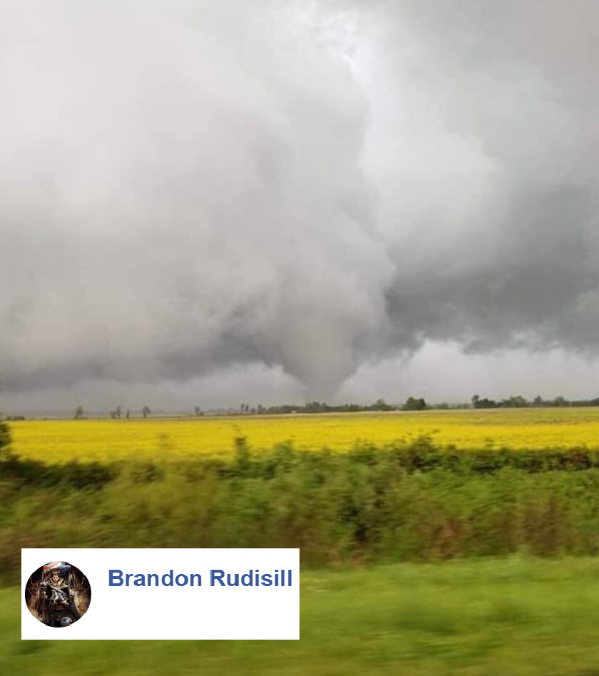
Local Storm Report by NWS MEG: Ridgely [Lake Co, TN] broadcast media reports FUNNEL CLOUD at 06:22 PM CDT -- possible tornado near ridgley
Update Hail likely in Fulton County now. Rotation near Woodland Mill, TN moving N NE 15 to 20
Update Lake County you are clear of severe for now. New storm to your west may enter your area shortly. Monitor.
I am tracking large hail moving into Fulton County and rotation 7 miles south of the city of Hickman, KY moving N NE at 20 mph
Pemiscot. Storm in your county has strong winds but for now, circulations have weakened. Stay aware.
Tracking a circulation near Hornbeak again and another near Dixie,TN. Anyone in this area should shelter. Moving N NE 15 to 20
Pemiscot new storm with a possible tornado near Bragg City. Seek shelter.
Storm with poss tornado and golfball size hail moving out of Lake/Obion Counties soon. Fulton, Hickman, Graves Counties be prepared to seek shelter.
Lake and western Obion County, TN should be in shelter.
Possible tornado near Hornbeak, TN Lake/Obion County moving N NE at 20. Stay sheltered.
Radar shows poss tornado near Samburg, TN. Lake/Obion County line. Moving N NE 20. Fulton County be alert.
New Madrid. The areas of concern are now to the east of you. Monitor updates as there are additional storms that are currently sub-severe.
Pemiscot the main storm of concern is almost out of your county. There are additional non-severe storms. Monitor updates.
Lake, Obion, Fulton I am tracking a circulation that could produce a tornado NE of Ridgely, TN moving N NE 20
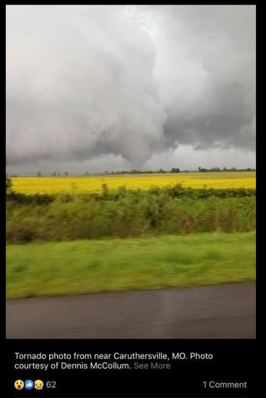
Pemiscot, SE New Madrid, Lake, west Obion. Several areas of rotation near Caruthersville, MO and Ridgely. Stay sheltered. Fulton be prepared.
Caruthersville, MO area in and near seek shelter now.
I am tracking rotation eastern Pemiscot County and one in Lake County. I would seek shelter till storms pass. Those north be alert, as well.
Possible tornado southern Lake County, TN moving N. Seek shelter if you are in the path of this storm.
.
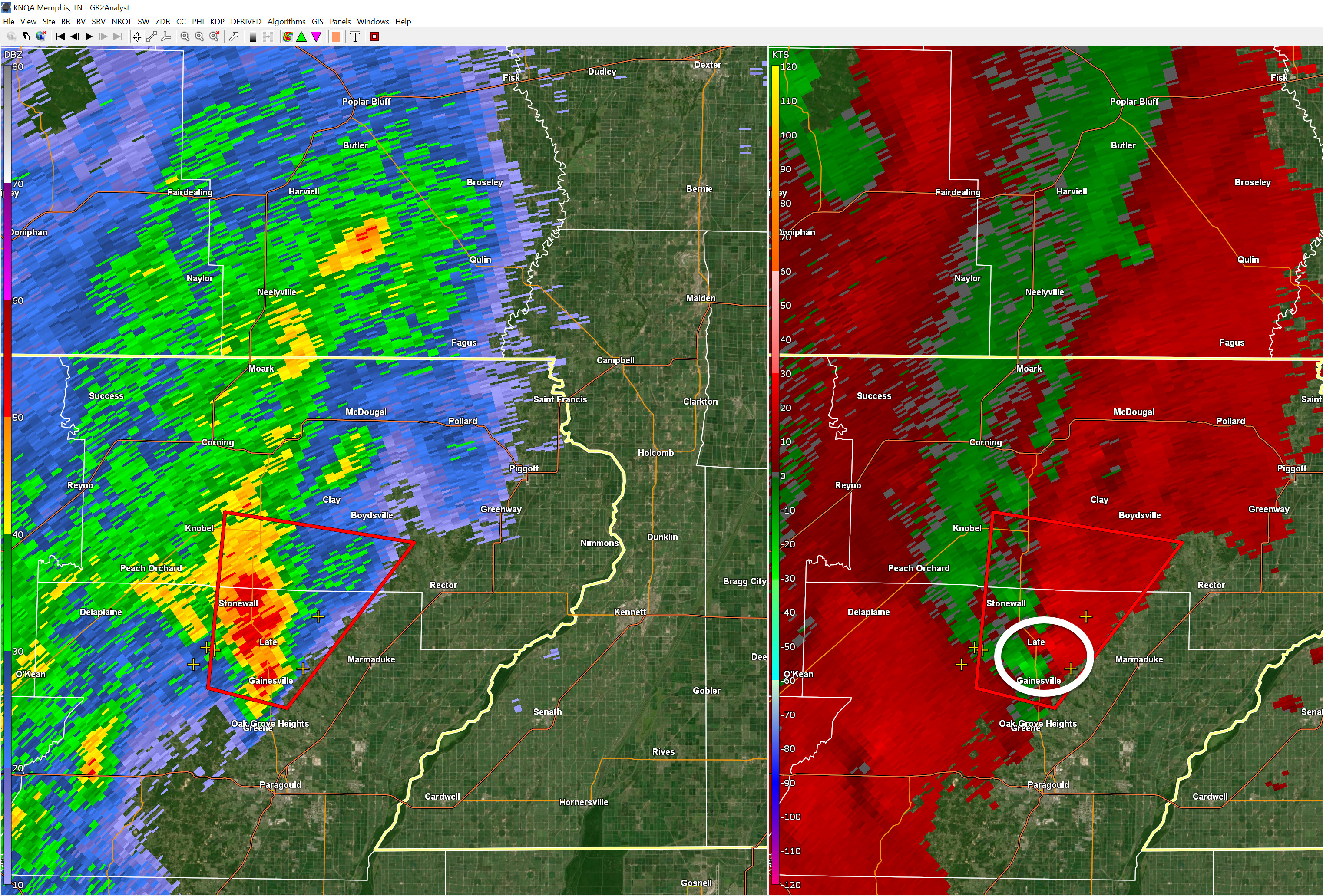
Spotter reported a tornado north of Hornersville Airport in Dunklin County. Remain sheltered and alert.
MEG issues Tornado Warning [tornado: RADAR INDICATED, hail: <.75 IN] for Dunklin [MO] and Clay, Greene [AR] till 6:30 PM CDT ...AT 554 PM CDT, DOPPLER RADAR INDICATED A SEVERE THUNDERSTORM PRODUCING A TORNADO WAS LOCATED NEAR ARBYRD, OR NEAR SENATH, MOVING NORTHEAST AT 20 MPH.
Rotation south of Senath in Dunklin County moving NNE 20. Be alert. Hai is also possible with the storms.
Update Storms in Dunklin & Pemiscot have weak rotation now. These storms have a history of weakening and then strengthening. Monitor updates.
Southern Dunklin and Pemiscot another area of rotation is entering extreme southern Dunklin County.
5:19 PM
Rotation is now in southern Pemiscot County. The rotation is broader now. A tornado is possible. Stay aware.
Live radar http://weatherobservatory.com/radar_pbluff.htm
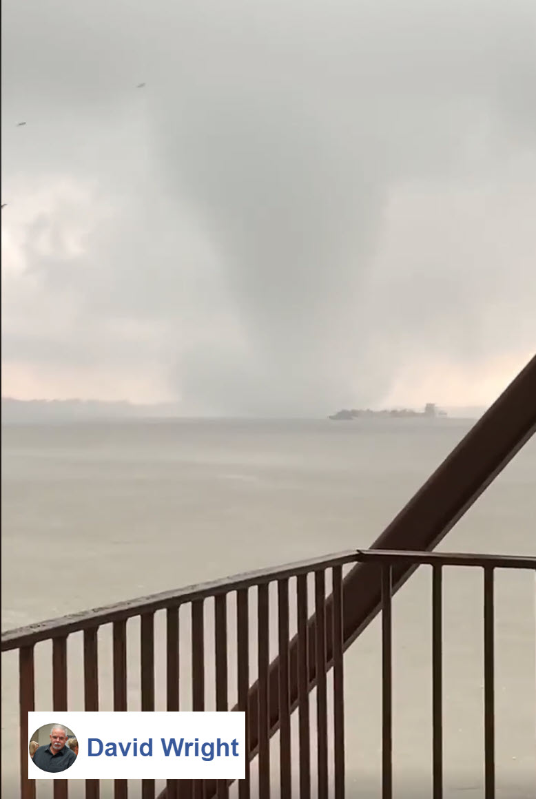
MEG continues Tornado Warning [tornado: RADAR INDICATED, hail: 1.25 IN] for Pemiscot [MO] and Mississippi [AR] till 5:30 PM CDT ...AT 515 PM CDT, DOPPLER RADAR INDICATED A SEVERE THUNDERSTORM PRODUCING A TORNADO WAS LOCATED 5 MILES NORTH OF BLYTHEVILLE, MOVING NORTHEAST AT 25 MPH.
5:12 PM
Rotation is now SW of Holland, MO areas in and near seek shelter until the storm passes.
5:08 PM
NWS left Dunklin County off the warning but it is very close. Seek shelter in SE southern Dunklin County, as well.
5:07 PM
The storm will enter Bootheel near the Dunklin/Pemiscot County line. Seek shelter now.
4:57 PM
I circled the circulations coming out of AR. White circles.
4:57 PM
Rotation SW of Blytheville, AR moving N NE 15 to 20. Be alert as this storm enters the Bootheel/NW TN.
4:54 PM
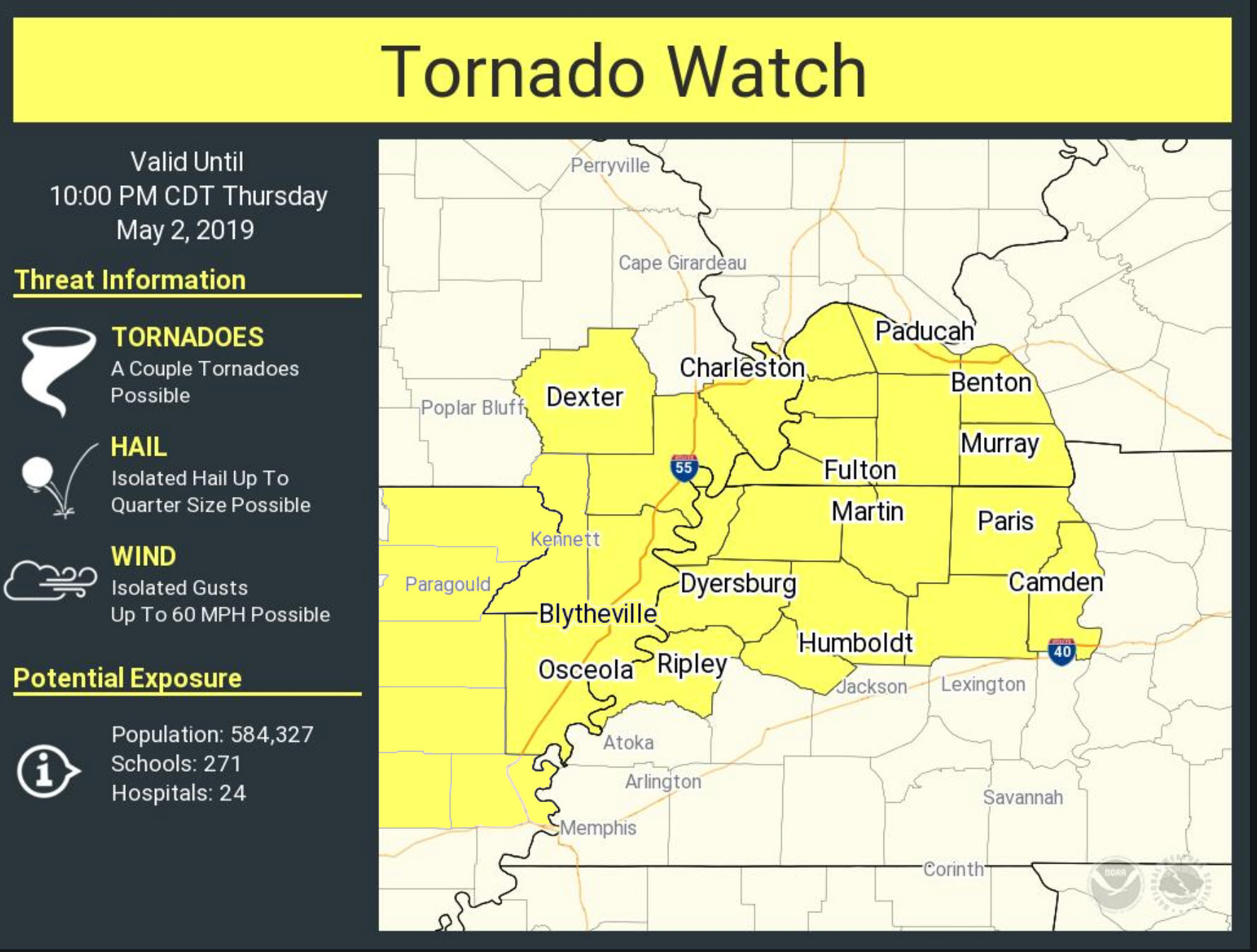
Tornado Watch has been issued
4:39 PM
New tornado watch coming shortly.

.
4:39 PM
Dunklin & Pemiscot I am monitoring a northbound storm near Blytheville, AR. Weak rotation but could strengthen. Monitor updates.
4:32 PM
4:32 PM
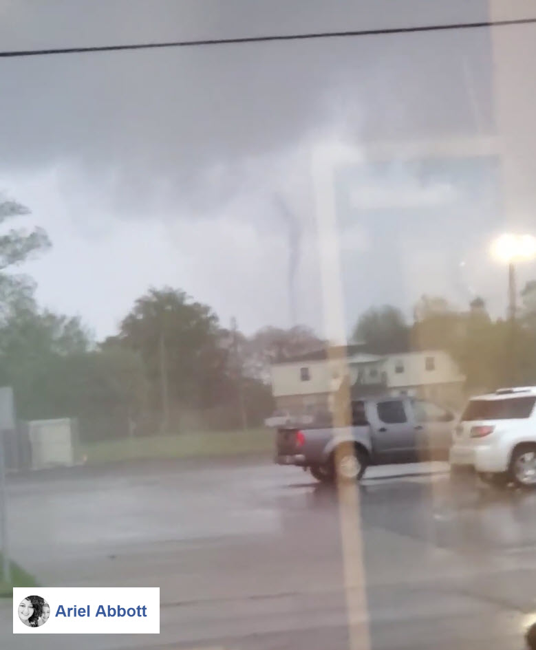
Tornado on the ground near Knob, AR in Clay County. The storm is moving NE at 25. Southern Butler, northern Dunklin, SW Stoddard, western New Madrid county be aware.
4:25 PM
Butler, Stoddard, and Dunklin. Storms coming out of AR have been producing short-lived tornadoes. They have been embedded in the rain. Be alert over the next one to two hours.
4:14 PM
MEG issues Tornado Warning [tornado: RADAR INDICATED, hail: <.75 IN] for Clay, Greene [AR] till 4:45 PM CDT ...AT 411 PM CDT, DOPPLER RADAR INDICATED A SEVERE THUNDERSTORM PRODUCING A TORNADO WAS LOCATED OVER LAFE, OR 7 MILES WEST OF MARMADUKE, MOVING NORTHEAST AT 15 MPH.
This storm is moving north out of AR. It will enter SE MO in the next hour or so.
Monitor updates.
.
4:00 PM
Severe Weather Update
No severe storms, yet.
An area of showers and thunderstorms continues to push out of Arkansas. This is the system that will help spark more showers and thunderstorms in our local area.
Continue to monitor updates.
3:05 PM
Here are some storm tracking tools.

Radar Link: Interactive local city-view radars & regional radars.
Here is a new regional radar that we bring to you Click Here
You will find clickable warning and advisory buttons on the local city-view radars.
3:05 PM
There are no immediate concerns for severe weather.
I am monitoring storms coming out of NE Arkansas. They will enter southeast Missouri and the Bootheel.
No severe concerns in Kentucky/Tennessee (for now). New storms will form over the coming hours.

.
2:30 PM
Tornado watch for the Bootheel. Additional watches are possible.
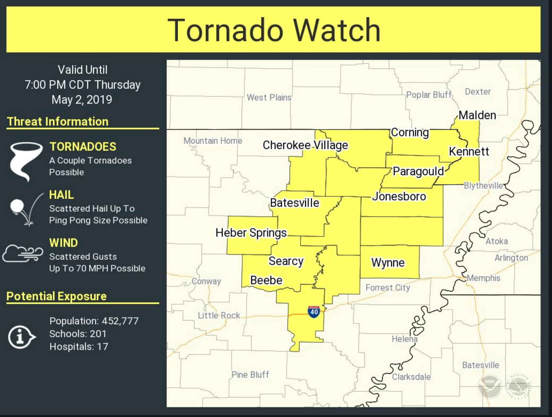
The risk of severe weather will continue into this evening. This will include parts of SE MO, far southern IL, western KY, and western TN.
1:30 PM
Flash flood update from WPC
Click to enlarge
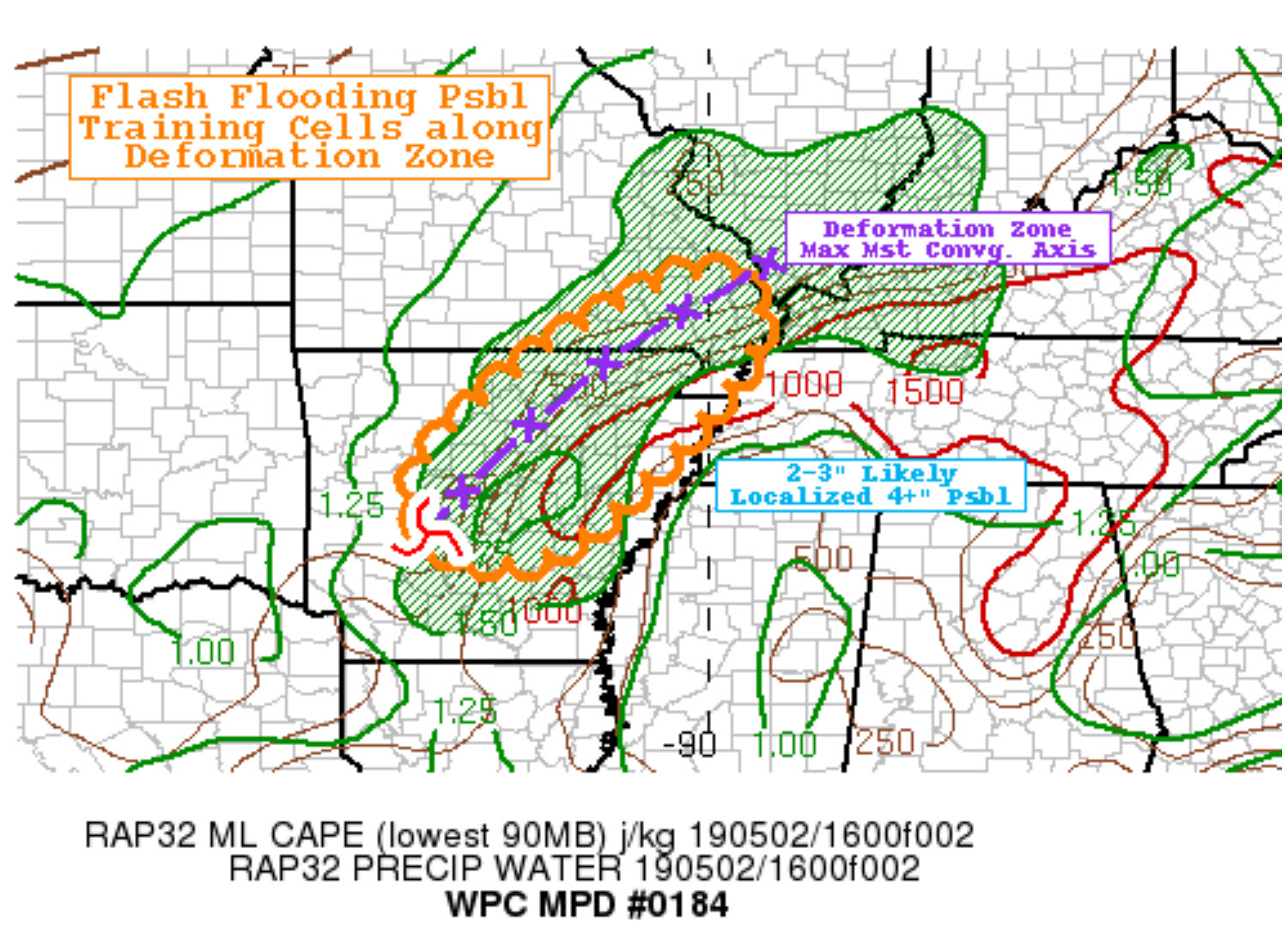
Click to enlarge
.
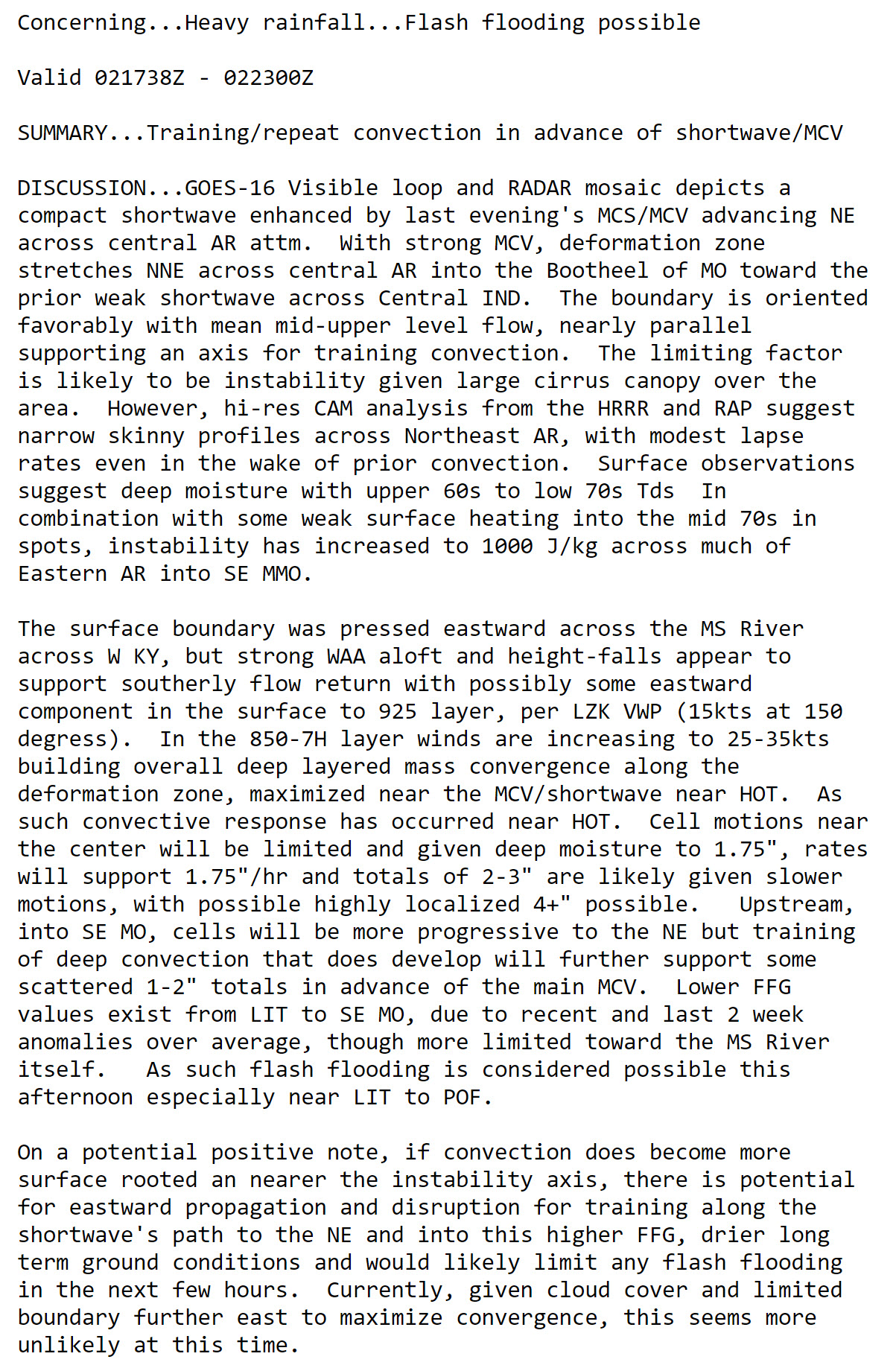
12:45 PM
60-hour rainfall forecast from the NAM model guidance.
This is a model. Take the general idea from it. It won't be exact.
Some locally heavy rain likely between now and Saturday evening.
.
11:45 AM
Models are handling the ongoing showers and thunderstorms poorly.
This raises questions about the afternoon and overnight forecast.
There is plenty of lift and moisture. We should continue to see widespread showers and thunderstorms.
Some of the storms could be intense this afternoon and evening over western Kentucky and western Tennessee.
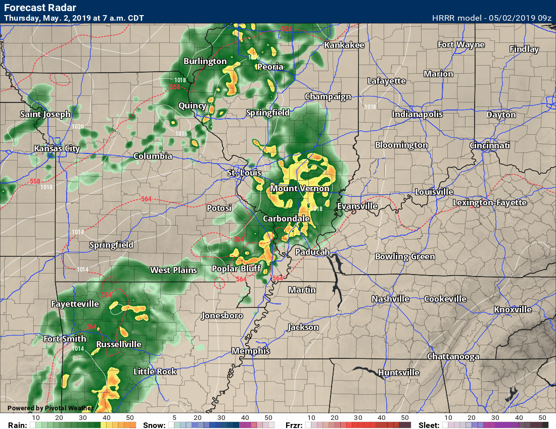
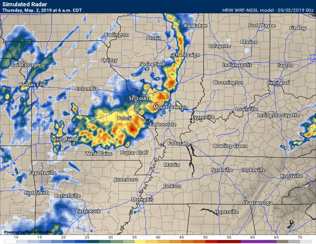
Here are two future-cast models
Keep in mind, these are models. They are struggling with this current set-up.
Hrrr model
WRF model
11:30 AM
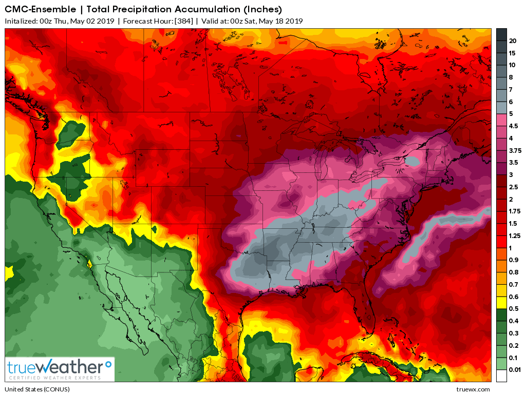
Guidance has been showing large range totals over the coming weeks.
What are ensembles?
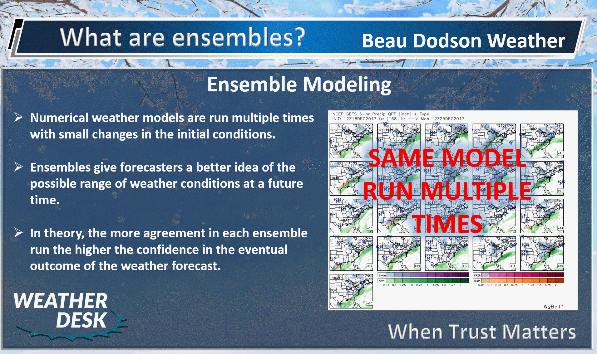
Here are a variety of model sets.
Needless to say, the wet pattern is likely to continue.
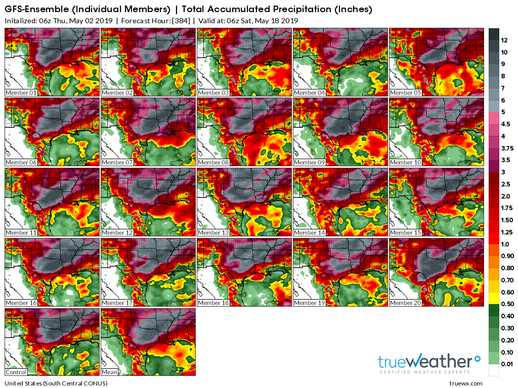
GFS Ensembles
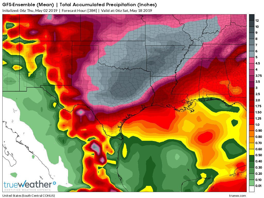
GFS Ensembles
CMC ensembles
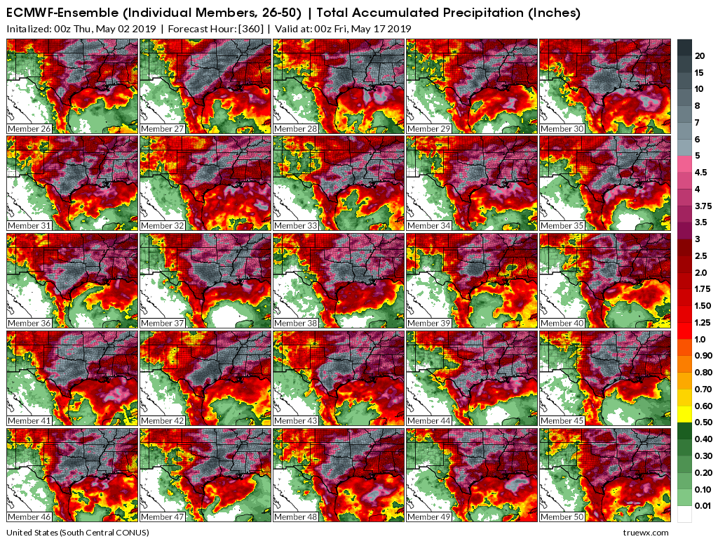
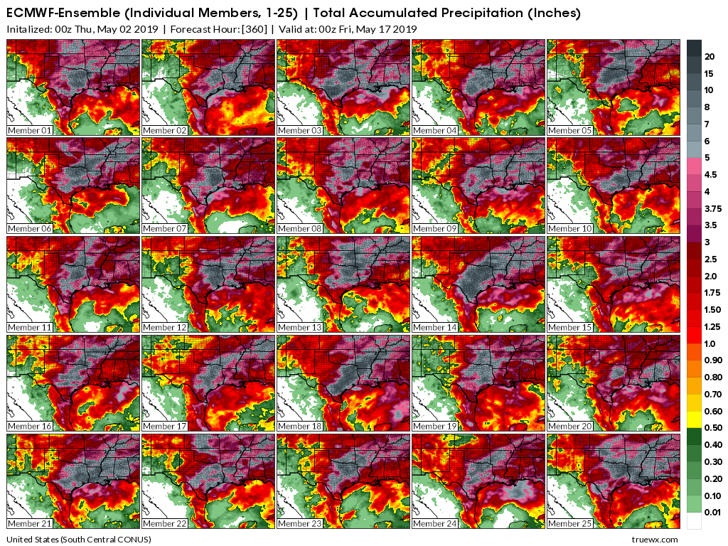
EC model guidance ensembles
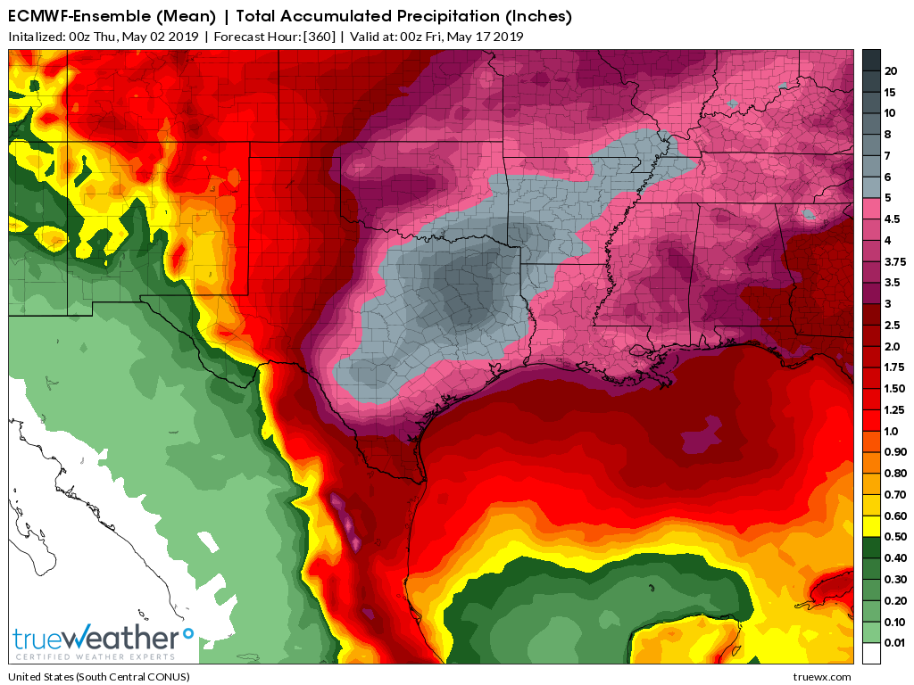
EC ensembles
Mesoscale Update
10:43 AM


.
Today: Thunderstorms today into tonight. Lightning will be a concern. Some of the storms could produce high winds, hail, and even isolated tornadoes. The severe weather risk will be highly dependent on the atmosphere become unstable as a morning round of showers and storms. Morning storms could produce high winds. Locally heavy rain could briefly cause flash flooding.
.
Tomorrow: Thunderstorms are possible Friday and Friday night. Lightning will be the concern tomorrow into tomorrow night. Saturday could have some lightning strikes, as well.
.

- Active/wet pattern will continue into next week and perhaps longer.
- Flooding.
.
.
Click here if you would like to return to the top of the page
.

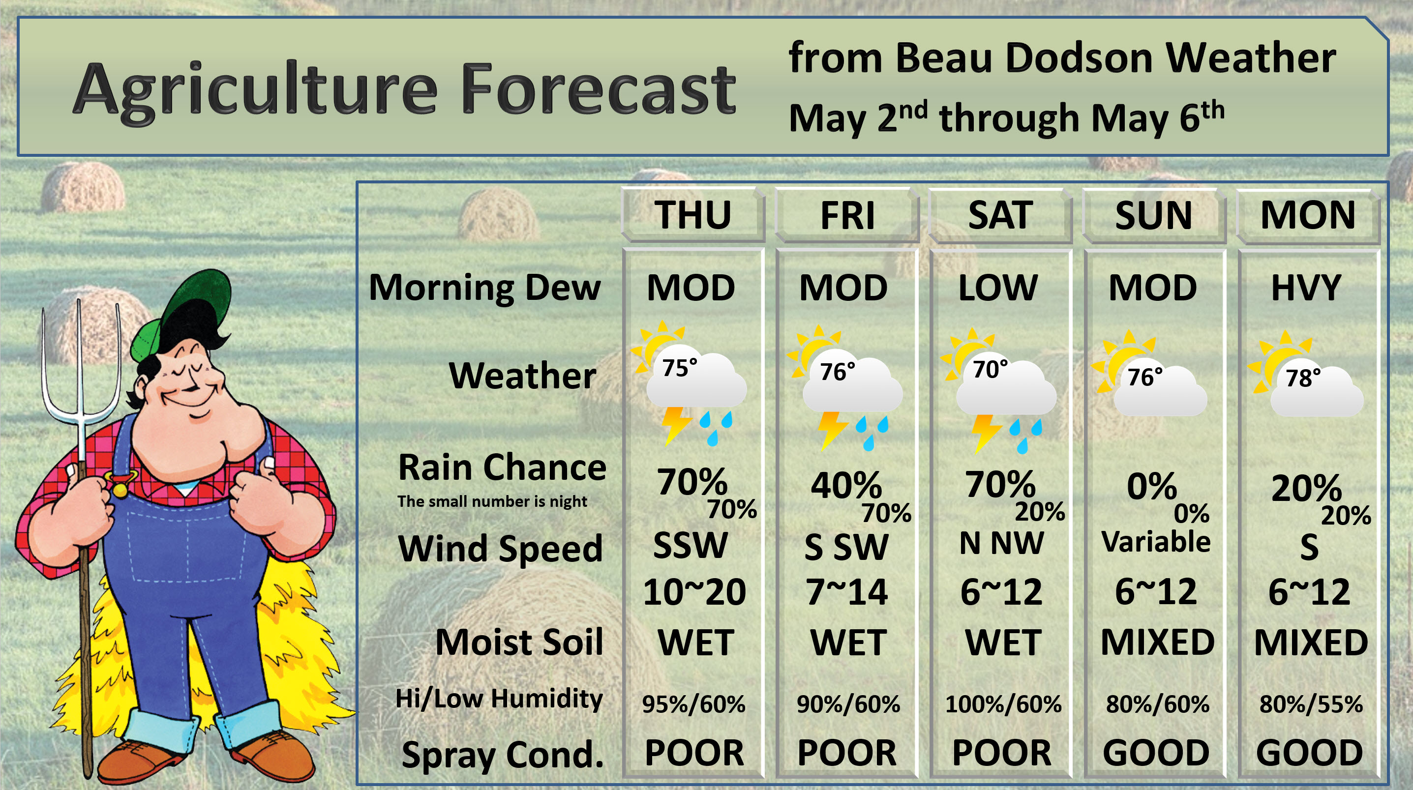
Thursday through Saturday night.
- Is lightning in the forecast? Yes. Lightning is possible today into Saturday.
- Is severe weather in the forecast? Yes. A few storms could produce high wind, hail, and isolated tornadoes Thursday and Thursday evening. The severe weather risk is dependent on the destabilization of the atmosphere after our morning thunderstorms. Morning storms could also produce high winds and small hail.
* The NWS officially defines severe weather as 58 mph wind or great, 1" hail or larger, and/or tornadoes - Is Flash flooding in the forecast? Possible. There is a flash flood risk. Locally heavy rain/storms could quickly produce an inch of rain. This is especially true where storms train over the same areas.
.

Sunday through Thursday
- Is lightning in the forecast? Yes. Lightning will be possible Monday onward. Some of the guidance holds showers and thunderstorms off until Tuesday.
- Is severe weather in the forecast? Monitor updates. Thunderstorms are possible Monday onward. Some of the guidance holds showers and thunderstorms off until Tuesday.
* The NWS officially defines severe weather as 58 mph wind or great, 1" hail or larger, and/or tornadoes - Is flash flooding in the forecast? Monitor updates. Periods of showers and thunderstorms will be possible next week. I will be monitoring the potential of heavy rain.
.
Today's Facebook weather discussion link
Click here
.
* The Missouri Bootheel includes Dunklin, New Madrid, and Pemiscot Counties
* Northwest Kentucky includes Daviess, Henderson, McLean Union, and Webster Counties
County Maps: Click Here
.
Have there been any changes in the forecast over the last 24 hours?
.
No major adjustments.
.
May 2, 2019
Thursday's Forecast: Quite a few clouds. Showers and thunderstorms. Some storms could be severe. Some heavy downpours are again possible.
My confidence in the forecast verifying: Medium (60% confidence in the forecast))
Temperature range: MO Bootheel 74° to 78° SE MO 70° to 75° South IL 74° to 78° Northwest KY (near Indiana border) 76° to 80° West KY 76° to 80° NW TN 76° to 80°
Wind direction and speed: South and southwest at 8 to 16 mph
Wind chill or heat index (feels like) temperature forecast: 74° to 82°
What is the chance/probability of precipitation? MO Bootheel 70% Southeast MO 70% IL 70% Northwest KY (near Indiana border) 70% Western KY 70% NW TN 80%
Note, what does the % chance actually mean? A 20% chance of rain does not mean it won't rain. It simply means most areas will remain dry.
Coverage of precipitation: Intervals of scattered to numerous
What impacts are anticipated from the weather? Wet roads. Lightning. Some storms could be intense. Locally heavy rain where storms occur. Isolated tornadoes.
Should I cancel my outdoor plans? I would have a plan B and monitor updates.
UV Index: 3 to 5 Moderate
Sunrise: 5:59 AM
.
Thursday night Forecast: Cloudy. Showers and thunderstorms. Some storms could be intense with hail, high winds, and tornadoes. A period of numerous showers and storms.
My confidence in the forecast verifying: Medium (60% confidence in the forecast)
Temperature range: MO Bootheel 60° to 64° SE MO 56° to 60° South IL 56° to 60° Northwest KY (near Indiana border) 58° to 62° West KY 58° to 64° NW TN 60° to 64°
Wind direction and speed: S to SW at 8 to 16 mph. Wind becoming variable at 6 to 12 mph
Wind chill or heat index (feels like) temperature forecast: 56° to 64°
What is the chance/probability of precipitation? MO Bootheel 60% Southeast MO 60% IL 60% Northwest KY (near Indiana border) 60% Western KY 70% NW TN 70%
Note, what does the % chance actually mean? A 20% chance of rain does not mean it won't rain. It simply means most areas will remain dry
Coverage of precipitation: Numerous
What impacts are anticipated from the weather? Wet roads. Lightning. Some storms could be intense with hail, high winds, and tornadoes. Locally heavy rain where storms occur.
Should I cancel my outdoor plans? I would have a plan B and monitor updates.
Sunset: 7:46 PM
Moonrise: 5:07 AM
The phase of the moon: Waning Crescent
Moonset: 5:36 PM
.
.
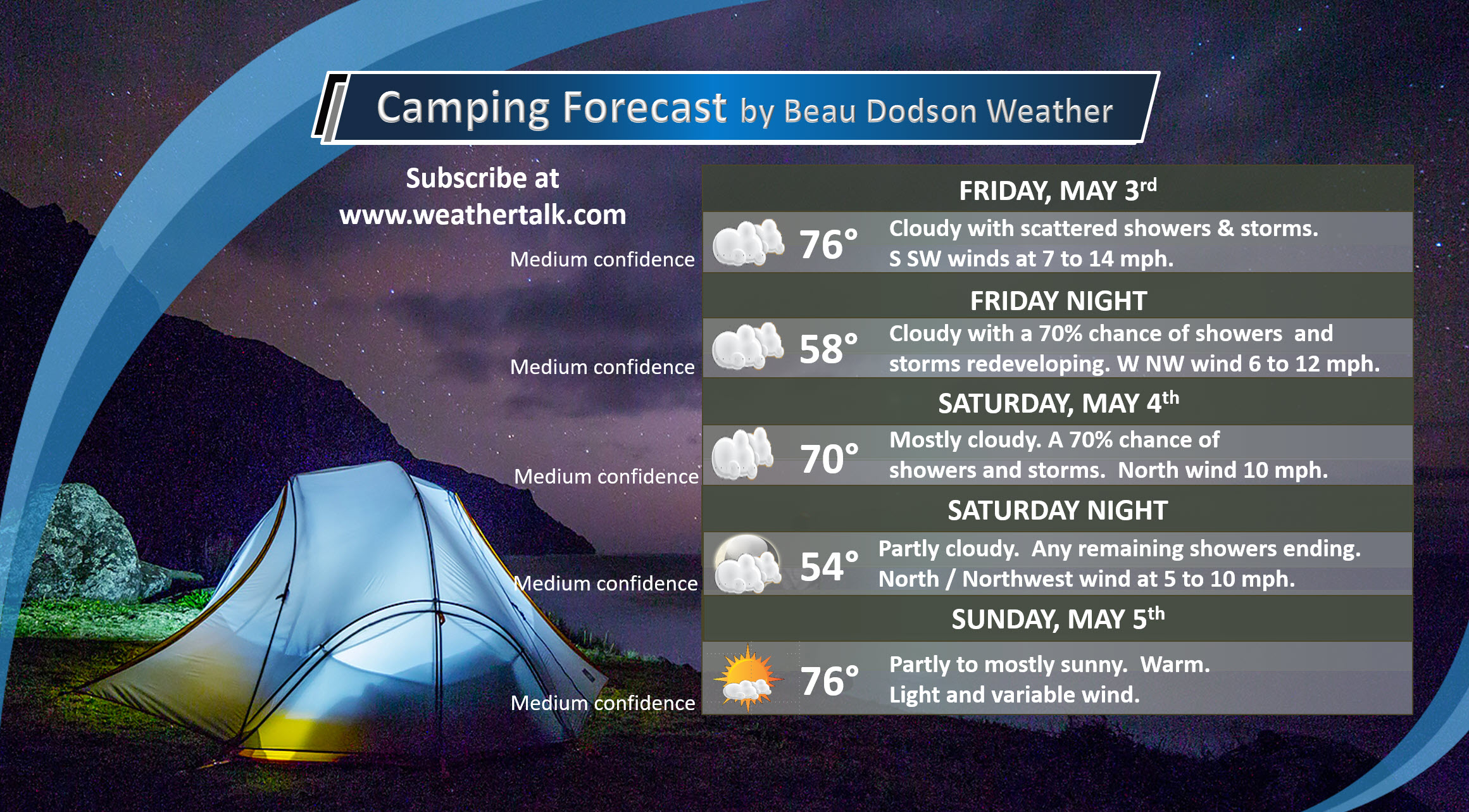
May 3, 2019
Friday's Forecast: A mix of sun and clouds. Scattered showers and thunderstorms are possible. Chances increase Friday night.
My confidence in the forecast verifying: Medium (40% confidence in the forecast))
Temperature range: MO Bootheel 76° to 80° SE MO 73° to 76° South IL 72° to 76° Northwest KY (near Indiana border) 74° to 78° West KY 76° to 80° NW TN 76° to 80°
Wind direction and speed: Variable wind 5 to 10 mph
Wind chill or heat index (feels like) temperature forecast: 72° to 80°
What is the chance/probability of precipitation? MO Bootheel 30% Southeast MO 30% IL 30% Northwest KY (near Indiana border) 30% Western KY 30% NW TN 30%
Note, what does the % chance actually mean? A 20% chance of rain does not mean it won't rain. It simply means most areas will remain dry.
Coverage of precipitation: Widely scattered
What impacts are anticipated from the weather? Wet roads. Lightning.
Should I cancel my outdoor plans? I would monitor radars and updates.
UV Index: 3 to 5 Moderate
Sunrise: 5:58 AM
.
Friday night Forecast: Mostly cloudy. Showers and thunderstorms are likely. Chances increase as we move through the night.
My confidence in the forecast verifying: Medium (50% confidence in the forecast)
Temperature range: MO Bootheel 58° to 62° SE MO 56° to 58° South IL 56° to 58° Northwest KY (near Indiana border) 56° to 60° West KY 56° to 60° NW TN 58° to 62°
Wind direction and speed: North and northwest at 5 to 10 mph
Wind chill or heat index (feels like) temperature forecast: 52° to 60°
What is the chance/probability of precipitation? MO Bootheel 70% Southeast MO 60% IL 60% Northwest KY (near Indiana border) 60% Western KY 60% NW TN 70%
Note, what does the % chance actually mean? A 20% chance of rain does not mean it won't rain. It simply means most areas will remain dry
Coverage of precipitation: Numerous
What impacts are anticipated from the weather? Wet roadways and lightning.
Should I cancel my outdoor plans? Monitor radars and updates.
Sunset: 7:46 PM
Moonrise: 5:36 AM
The phase of the moon: Waning Crescent
Moonset: 6:36 PM
.
.
May 4, 2019
Saturday's Forecast: Cloudy. Showers likely. Some thunderstorms are also possible.
My confidence in the forecast verifying: Medium (60% confidence in the forecast))
Temperature range: MO Bootheel 66° to 72° SE MO 66° to 74° South IL 66° to 72° Northwest KY (near Indiana border) 66° to 72° West KY 68° to 74° NW TN 68° to 74°
Wind direction and speed: North 4 to 8 mph
Wind chill or heat index (feels like) temperature forecast: 74° to 82°
What is the chance/probability of precipitation? MO Bootheel 70% Southeast MO 70% IL 60% Northwest KY (near Indiana border) 60% Western KY 70% NW TN 80%
Note, what does the % chance actually mean? A 20% chance of rain does not mean it won't rain. It simply means most areas will remain dry.
Coverage of precipitation: Numerous
What impacts are anticipated from the weather? Wet roads. Lightning.
Should I cancel my outdoor plans? Have a plan B.
UV Index: 3 Low to moderate. If clouds persist then lower numbers.
Sunrise: 5:57 AM
.
Saturday night Forecast: Cloudy early. Any remaining showers will end.
My confidence in the forecast verifying: Medium (50% confidence in the forecast)
Temperature range: MO Bootheel 50° to 54° SE MO 48° to 54° South IL 48° to 52° Northwest KY (near Indiana border) 50° to 54° West KY 52° to 54° NW TN 53° to 56°
Wind direction and speed: North and northwest at 5 to 10 mph
Wind chill or heat index (feels like) temperature forecast: 48° to 55°
What is the chance/probability of precipitation? MO Bootheel 20% Southeast MO 20% IL 20% Northwest KY (near Indiana border) 30% Western KY 30% NW TN 20%
Note, what does the % chance actually mean? A 20% chance of rain does not mean it won't rain. It simply means most areas will remain dry
Coverage of precipitation: Ending
What impacts are anticipated from the weather? Wet roadways and lightning early in the evening.
Should I cancel my outdoor plans? No. Check radars before 6 PM.
Sunset: 7:47 PM
Moonrise: 6:06 AM
The phase of the moon: New
Moonset: 7:38 PM
.
Sunday: Medium to high confidence. Some morning clouds. Becoming mostly sunny. Warm. High temperatures in the middle to upper 70s. Low temperatures in the middle to upper 50s. Variable winds. Light winds.
.
Monday: Medium confidence. Partly cloudy. A 20% to 20% chance of showers and thunderstorms both Monday and Monday night. Monitor these rain probabilities. They will likely need adjusting as confidence in the final forecast increases. Warm. High temperatures in the upper 70s to lower 80s. Low temperatures in the upper 50s to lower 60s. Southerly wind at 6 to 12 mph.
.
Tuesday: Medium confidence. Partly cloudy. A 30% to 40% chance of showers and thunderstorms both Tuesday and Tuesday night. Monitor these rain probabilities. They will likely need adjusting as confidence in the final forecast increases. Warm. High temperatures in the upper 70s to lower 80s. Low temperatures in the lower 60s. South winds 7 to 14 mph and gusty.
Learn more about the UV index readings. Click here.
.
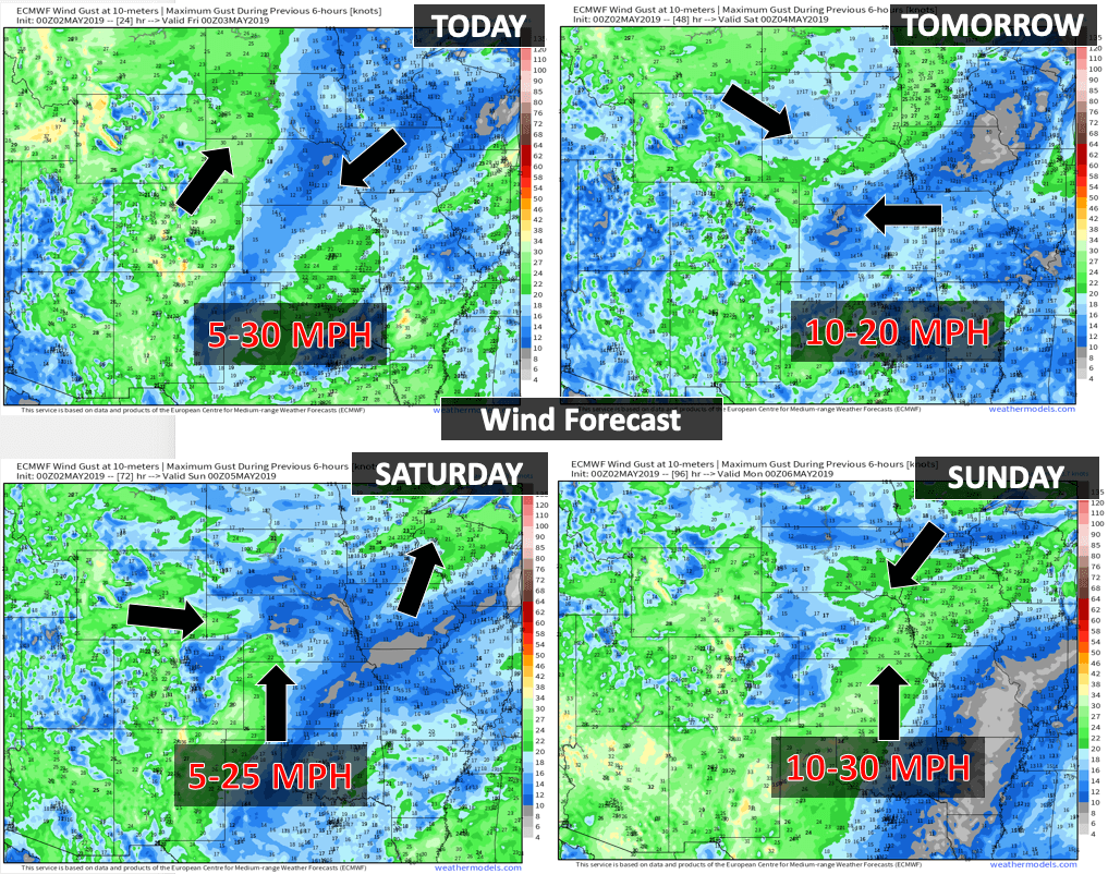
Wind forecast
Click to enlarge
This will be updated again around 8 AM
.
.
Graphic-cast
Click here if you would like to return to the top of the page
.
** These graphic-forecasts may vary a bit from my forecast above **
CAUTION: I have these graphics set to auto-update on their own. Make sure you read my hand-typed forecast above.
During active weather check my handwritten forecast.
.
Missouri


.
Illinois
** These graphic-forecasts may vary a bit from my forecast above **
CAUTION: I have these graphics set to auto-update on their own. Make sure you read my hand-typed forecast above.
During active weather check my handwritten forecast.


.
Kentucky
** These graphic-forecasts may vary a bit from my forecast above **
CAUTION: I have these graphics set to auto-update on their own. Make sure you read my hand-typed forecast above.
During active weather check my handwritten forecast.


.
Tennessee
** These graphic-forecasts may vary a bit from my forecast above **
CAUTION: I have these graphics set to auto-update on their own. Make sure you read my hand-typed forecast above.
During active weather check my handwritten forecast.


.
.

The National Weather Service defines a severe thunderstorm as one that produces quarter size hail or larger, 58 mph winds or greater, and/or a tornado.
.
Today and tomorrow: Lightning is possible today into tomorrow. Large hail, damaging wind, and tornadoes will be possible this afternoon and tonight.
Saturday through Wednesday: Lightning is possible Friday and Saturday and then again on Monday through Wednesday. Severe weather is not anticipated Friday through Sunday. I would encourage you to monitor updates concerning the Monday through Wednesday part of the forecast. Locally intense storms are possible.
.
Let me show you the Storm Prediction Center's severe weather outlooks. I do not normally post these because they are constantly changing them.
Today is a conditional risk. Morning storms could keep the atmosphere a bit more stable this afternoon. If this morning round of clouds and storms does help stabilize the atmosphere then a second round of severe weather is unlikely.
This remains a question. If some spotty sun can break through the clouds today then the risk of severe weather will increase this afternoon and evening.
Light green is where storms are possible but not likely to be severe.
The dark green is a level one risk. Yellow is a level two risk. What does that mean? It means that a few thunderstorms could produce hail and damaging wind. Lightning, of course. Heavy rain, as well.
I can't rule out some severe thunderstorm/tornado watches and warnings.
Monitor updates, as always. It only takes one bad storm to ruin the day.
Thursday's outlook (below).
Dark green is a level one risk. Yellow is a level two out of five risk. One being the lowest and five being the highest.
Monitor Thursday's forecast. Some severe storms are likely in the region.
THESE GRAPHICS ARE AUTO-UPDATED
** THE GRAPHIC YOU CURRENTLY SEE WON'T BE THE GRAPHIC FROM YESTERDAY.
IT WILL BE THE CURRENT GRAPHIC **

The black outline is our local area.

..
Be sure and have WeatherOne turned on in your WeatherTalk accounts. That is the one for winter storms, ice storms, and severe weather.
Log into your www.weathertalk.com
Click the personal notification settings tab.
Turn on WeatherOne. Green is on. Red is off.
.

Here is the latest graphic from the WPC/NOAA.
.
This map shows precipitation totals.
.
24-hour precipitation outlook.
.

.
48-hour precipitation outlook.
.
.
.
72-hour precipitation outlook.
.

.
Totals added together. This includes day one through seven.

.

- More showers and thunderstorms.
- Some severe storms are possible Thursday and Thursday night.
- Sunday is the pick day of the weekend.
- Additional showers and thunderstorms next week.
- Active weather pattern.
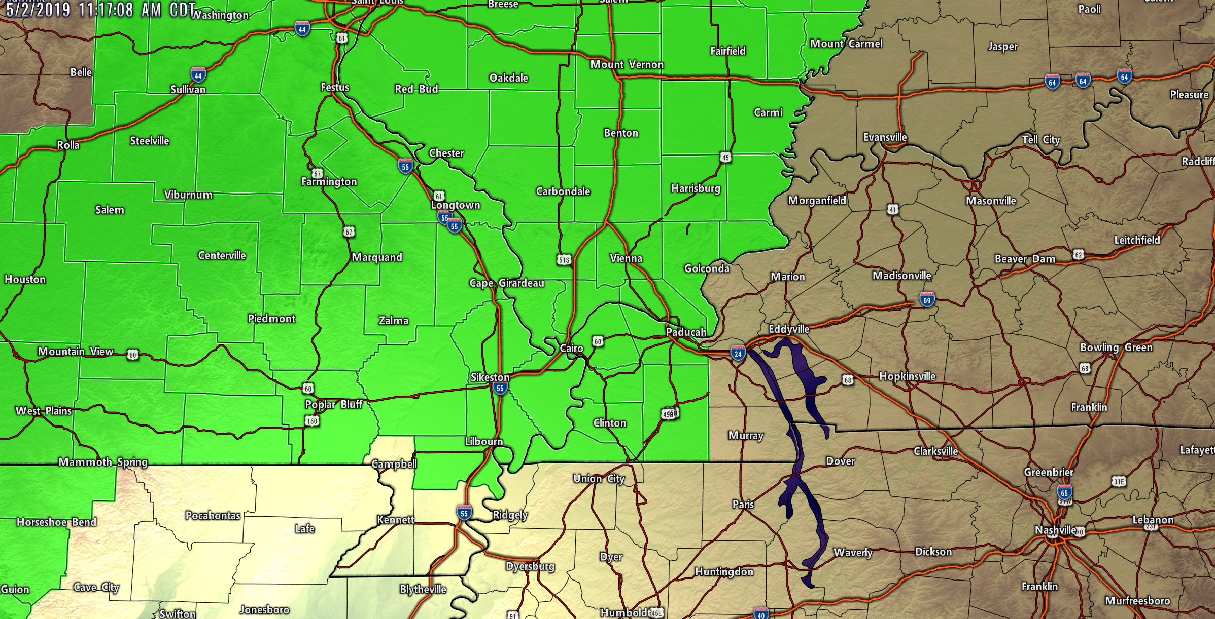
Current conditions.

.
Click here if you would like to return to the top of the page
.
Forecast discussion.
.
Today and tomorrow.
I am closely monitoring Thursday's weather. The ingredients are coming together for severe thunderstorms. That would include a threat of a tornado. Let's keep a close eye on the Thursday forecast.
Scattered showers and likely non-severe thunderstorms are possible on Friday and Friday night, as well.
What could disrupt the severe risk on Thursday?
Morning clouds and widespread showers and thunderstorms would help keep instability lower. If that occurs then the severe weather risk will be lower.
When the sun is out it heats the ground. Heating the ground warms the atmosphere. A warmer atmosphere means higher CAPE values. CAPE is basically energy for thunderstorms to tap into.
Monitor updates Thursday. I will post updates at the top of this page as showers and thunderstorms push through the region.
Remember, a warning means to seek shelter. I can't rule out tornadoes from this event.
Saturday
Finally, Saturday is starting to appear wetter and wetter. It now appears that a wave of low pressure will move along our stalled front. This will spread widespread rain back into the region Friday night into Saturday afternoon.
Some moderate rain is possible on Saturday.
The atmosphere drys out Saturday night.
Sunday will be dry. Sunday continues to be the pick day of the weekend. Highs will be in the middle to upper 70's.
We can not shake this wet pattern.
.
Heavy rain concerns.
I am concerned that this active pattern may linger into next week and the following week.
Significant flooding of rivers is ongoing over parts of Missouri and Illinois. This pattern will produce increasing flooding concerns along the Missouri and Mississippi Rivers (and other rivers, as well).
This seems to be the year of the flood.
Here are the latest WPC/NOAA excessive rainfall outlooks. This shows you where the risk of flash flooding/flooding will be the highest.
Thursday's Excessive Rainfall Outlook
Green is a level one risk of excessive rainfall (flash flooding). Yellow is a level two risk of flash flooding. Red is a level three risk of flash flooding. There are four levels. Four being the highest.
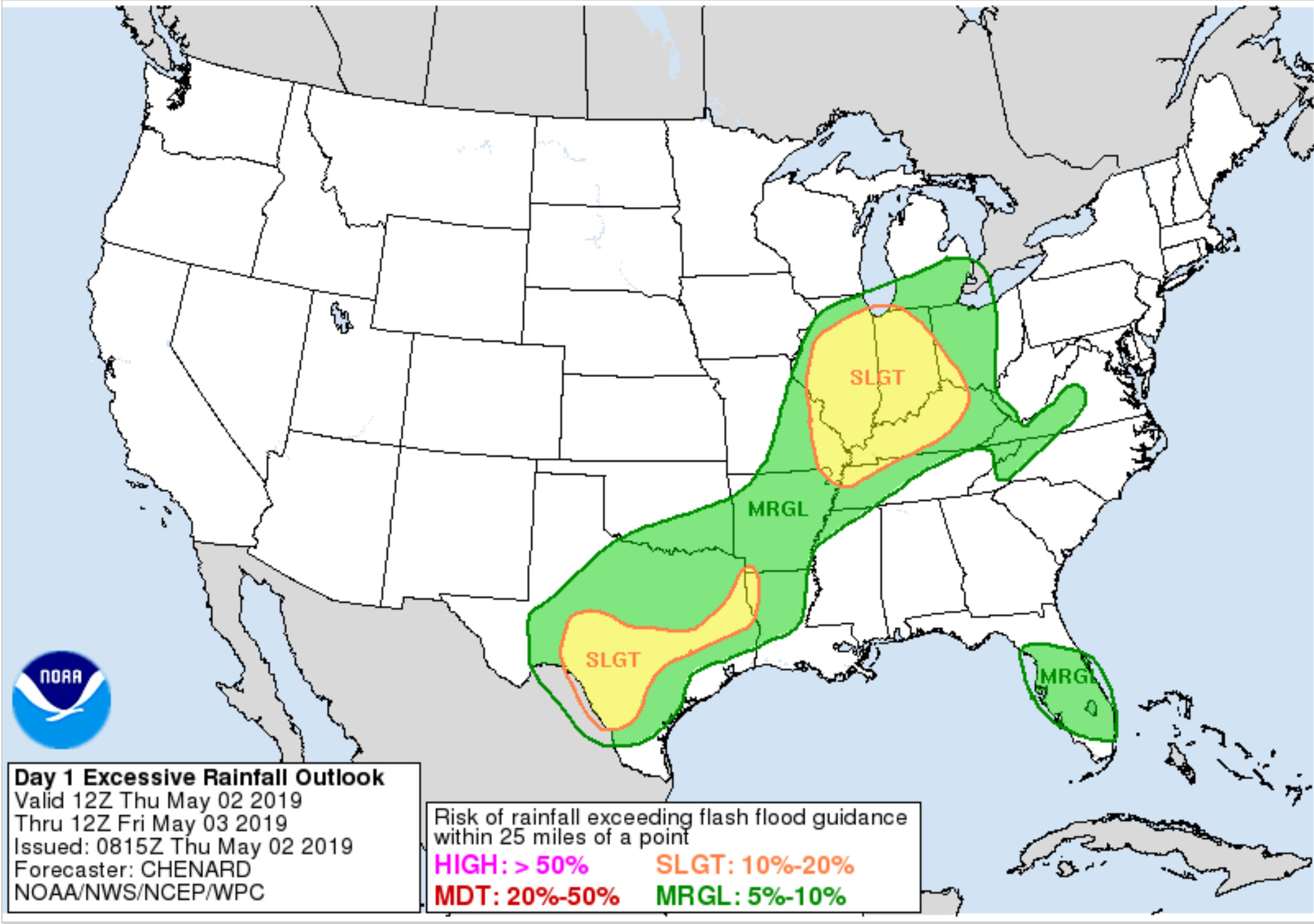
Friday's Excessive Rainfall Outlook
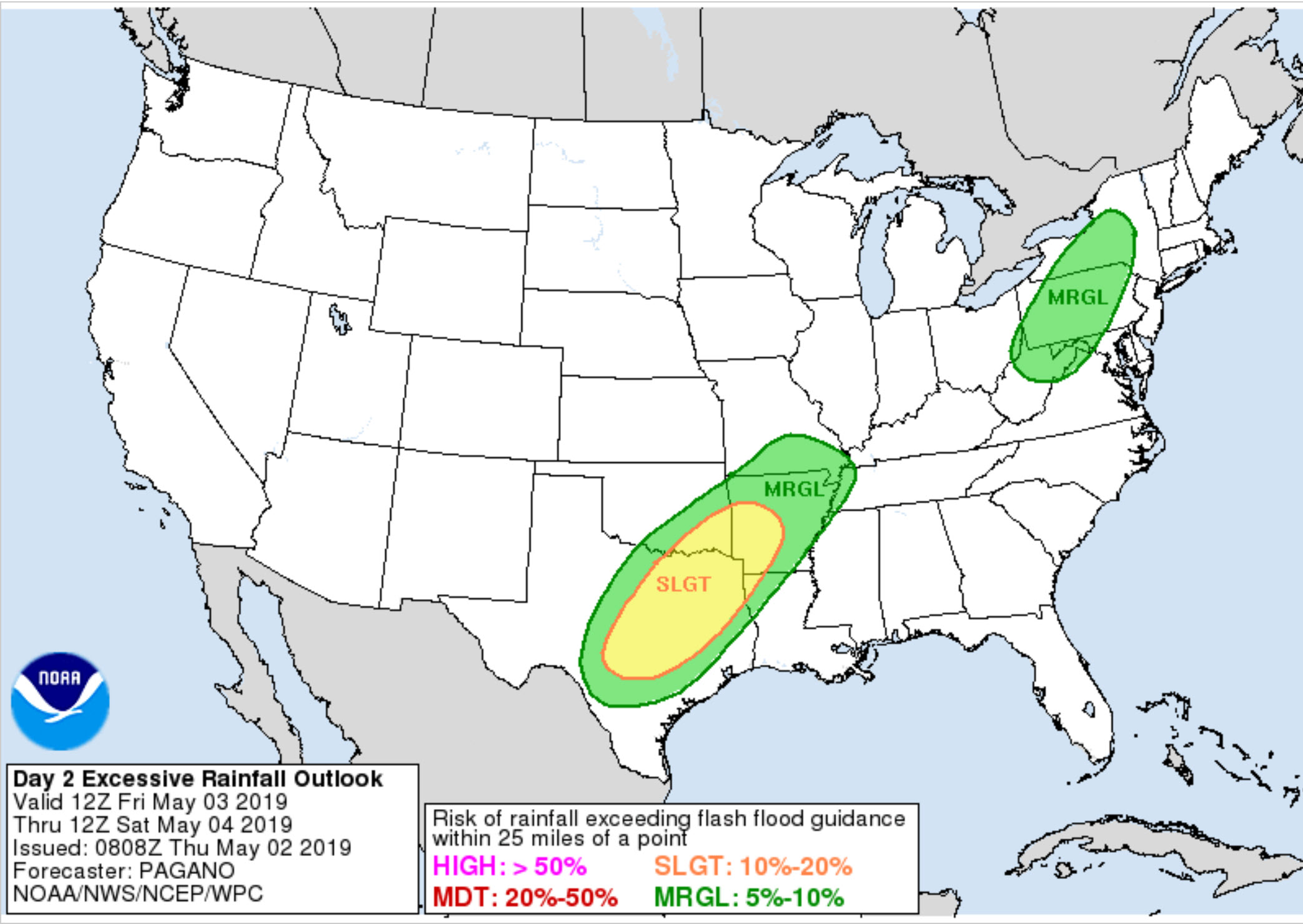
Saturday's Excessive Rainfall Outlook

.
Long Range
Monday through Friday
Showers and thunderstorms are possible Monday into Friday. It won't rain all of the time, of course. There will also be time periods when the brunt of the shower and thunderstorm activity focuses on certain portions of my forecast area.
Those finer details will need to be ironed out.
It does appear that we could have rain chances every day next week. Obviously, farmers in much of the region need a break.
Click here if you would like to return to the top of the page
Model Future-cast Radars. What the models believe the radar may look like.
.
Remember, these are models. They are never 100% accurate. Take the general idea from them.
Models are going to struggle with this type of pattern.
Small ripples of energy will rise along the stalled boundary. Each can produce showers and thunderstorms.
Timing them can be tricky, at best. Plan on scattered showers and storms over the next few days. Some storms will be locally heavy.
.
Here is the Hrrr model guidance.
Again, as a reminder, these are models. They are never 100% accurate. Take the general idea from them.
Models do not handle this pattern all that well.
.
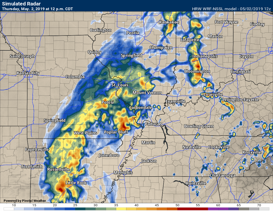
Here is the high-resolution WRF model guidance.
Time-stamp upper left.
.
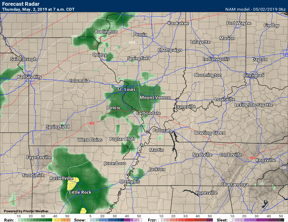
.Here is the high-resolution NAM 3K model.
Time-stamp upper left.
.
Here is the NAM future-cast radar. NAM is another model. This is the lower resolution version.
Time-stamp upper left.
.
.
Looking even further out. The GFS is quite active as we move into May.
This is a longer animation. I just wanted to show you how active this model is.

.
These maps update several times a day. Occasionally, in between updates, you may see a duplicate day or one out of sync.
Forty-eight-hour temperature outlook.


*****
*****
![]()
These are bonus videos and maps for subscribers. I bring these to you from the BAMwx team. I pay them to help with videos.
The Ohio and Missouri Valley videos cover most of our area. They do not have a specific Tennessee Valley forecast but they may add one in the future.
The long-range video is a bit technical. Over time, you can learn a lot about meteorology from the long range video.
NOTE: These are usually not updated on Saturday or Sunday unless there is active weather.

Click here if you would like to return to the top of the page
.
These are bonus videos.
I pay BAMwx to help with videos.
They do not currently have a Kentucky/Tennessee specific video.
The Ohio Valley video does capture our region.
The Ohio Valley video
.

Long Range Video
.

Missouri Valley Video
.![]() .
.

I bring the following long-range outlooks from the BAMwx team. They are excellent long-range forecasters. These are more detailed than the images above.
.
Remember, long-range outlooks are always going to be a lower confidence level than short-term forecasts.
.
Long-range forecasting is not an exact science. There are many variables that determine the eventual outcome of a long-range forecast.
.

.
Outlook definitions
EC = Equal chances of above or below normal
BN= Below normal
M/BN = Much below normal
AN = Above normal
M/AN = Much above normal
E/AN = Extremely above normal
.
Normal high temperatures for this time of the year are around 73 degrees.
Normal low temperatures for this time of the year are around 52 degrees.
Normal precipitation during this time period ranges from 0.90" to 1.20"
This outlook covers May 2nd through May 8th
..
The precipitation forecast is PERCENT OF NORMAL. For example, if your normal rainfall is 1.00" and the graphic shows 25%, then that would mean 0.25" of rain is anticipated.
.

Normal high temperatures for this time of the year are around 74 degrees
Normal low temperatures for this time of the year are around 53 degrees
Normal precipitation during this time period ranges from 0.90" to 1.20"
.
This outlook covers May 9th through May 15th
.
.
The precipitation forecast is PERCENT OF NORMAL. For example, if your normal rainfall is 1.00" and the graphic shows 25%, then that would mean 0.25" of rain is anticipated.

.
Outlook definitions
EC = Equal chances of above or below normal
BN= Below normal
M/BN = Much below normal
AN = Above normal
M/AN = Much above normal
E/AN = Extremely above normal
.
Normal high temperatures for this time of the year are around 77 degrees
Normal low temperatures for this time of the year are around 55 degrees
Normal precipitation during this time period ranges from 1.70" to 2.40"
.
This outlook covers May 10th through May 23rd
.
The precipitation forecast is PERCENT OF NORMAL. For example, if your normal rainfall is 1.00" and the graphic shows 10%, then that would mean 0.10" of rain is anticipated.

Click here to go to the top of the page
.
Outlook definitions
EC= Equal chances of above or below normal
BN= Below normal
M/BN = Much below normal
AN = Above normal
M/AN = Much above normal
E/AN = Extremely above normal
.
May temperature and precipitation outlook
.
Here is the preliminary March, April, and May temperature and precipitation forecast.
.
March, April, and May temperature outlook
.
March, April, and May precipitation outlook
.
June temperature outlook
June precipitation outlook
.
July temperature outlook
July precipitation outlook
..
August temperature outlook
August precipitation outlook
.
Preliminary summer outlook
.
.
Radar Link: Interactive local city-view radars & regional radars.
You will find clickable warning and advisory buttons on the local city-view radars.
If the radar is not updating then try another one. If a radar does not appear to be refreshing then hit Ctrl F5. You may also try restarting your browser.
Not working? Email me at beaudodson@usawx.com
National map of weather watches and warnings. Click here.
Storm Prediction Center. Click here.
Weather Prediction Center. Click here.
.

Live lightning data: Click here.
.

Interactive GOES R satellite. Track clouds. Click here.
GOES 16 slider tool. Click here.
College of Dupage satellites. Click here
.

Here are the latest local river stage forecast numbers Click Here.
Here are the latest lake stage forecast numbers for Kentucky Lake and Lake Barkley Click Here.
.
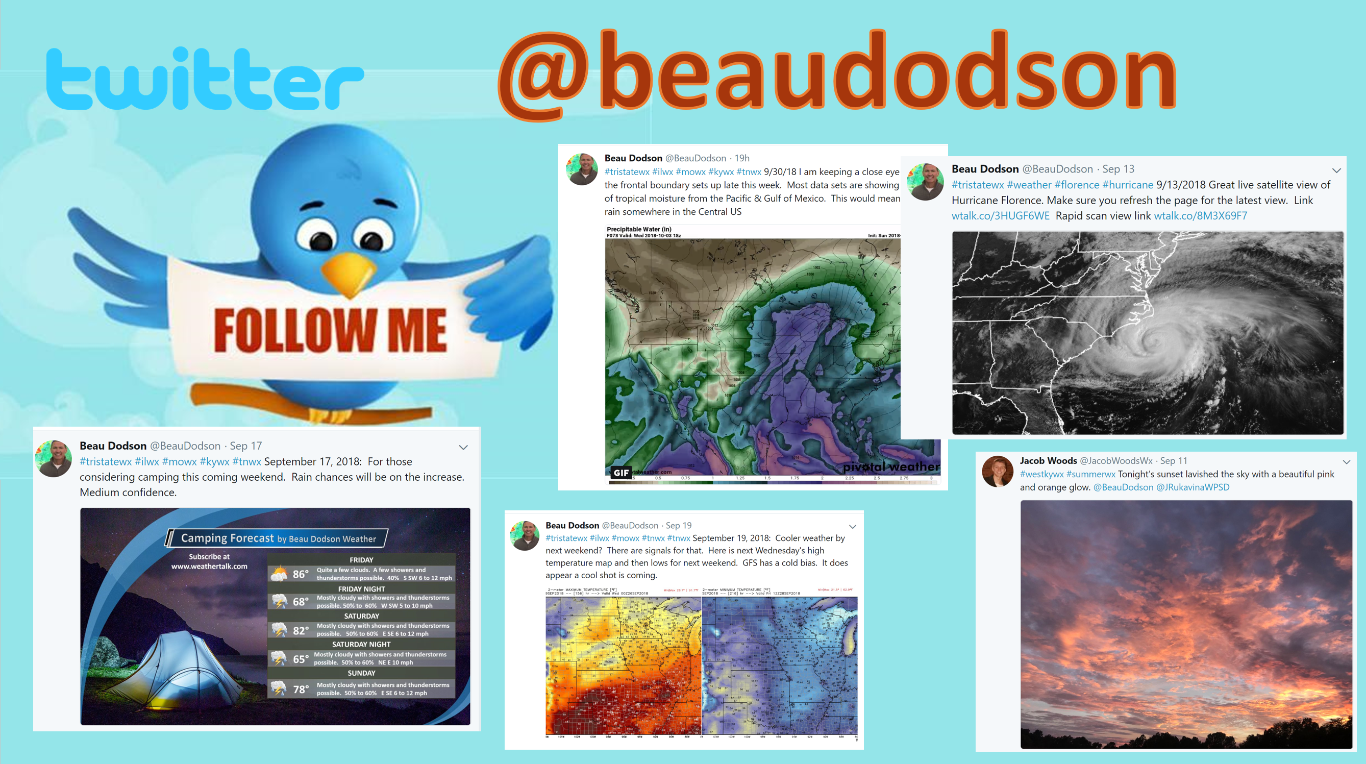
Did you know that you can find me on Twitter? Click here to view my Twitter weather account.
.
Not receiving app/text messages?
- Make sure you have the correct app/text options turned on. Do that under the personal notification settings tab at www.weathertalk.com. Red is off. Green is on.
- USE THE APP. Verizon and ATT have been throttling text messages. The app receives the same messages instantly. Texts can take longer. Please, use the app. It is under Beau Dodson Weather in the app stores.


Tonight’s guest WeatherBrain is the Warning Coordination Meteorologist at the NWS Office in Memphis, TN. He is a 31-year veteran of the NWS, and worked at offices in west Texas, north Texas, and Phoenix AZ before moving to Memphis. He received his Bachelors Degree in Meteorology from Florida State, and his Masters from the University of Oklahoma. He has focused on severe storms and storm spotter training throughout his career, and has helped develop spotter training materials that were and are used nationwide. Gary Woodall, welcome to WeatherBrains!
Tonight’s second guest WeatherBrain is a graduating senior from the University of Oklahoma’s School of Meteorology. She is Oklahoma Weather Labs Director of Operations and a Senior Representative to the OU School of Meteorology Student Affairs Committee. Also, she is Deputy Director of the New Student Mentoring Program and a member of the OU Nightly Weather Team. Leah Hill, welcome to WeatherBrains!
Other discussions in this weekly podcast include topics like:
- What role does social media play in severe weather events?
- How should the NWS word severe weather warnings and statements?
- POD/FAR emphasis
- Issues with the general public not being able to find themselves on a map
- The Astronomy Report from Tony Rice
- and more!
.
.
Previous episodes can be viewed by clicking here.
.
Find Beau on Facebook! Click the banner.

.
Find Beau on Twitter! Share your weather photos! @beaudodson

Click here to go to the top of the page
Did you know that a portion of your monthly subscription helps support local charity projects? Not a subscriber? Becoming one at www.weathertalk.com
You can learn more about those projects by visiting the Shadow Angel Foundation website and the Beau Dodson News website.