Weather Blog Post
Last Updated: Jul 07, 2019 8:59 PM
June 23, 2019
BEGIN LIVE BLOG
.

Live lightning data: Click here.

Radar Link: Interactive local city-view radars & regional radars.
.
County Maps: Click Here
.
FACEBOOK Q&A LINK
CLICK HERE
.
Live-interactive radars: Click here
Regional radar link: Click here
.
Live lightning data: Click here.
.
Additional storm tracking tools can be found at the bottom of the page.
.
7:24 PM
7:31 PM Todd. One more storm moving through. Gusty winds. Tornado risk appears to be over.
Expires Tornado Warning for Todd [KY]
.
7:16 PM
Christian County tornado warning ended. Todd County continues. Rotation 7 miles NW of Elkton moving NE at 40
.
7:00 PM
Christian and Todd. The main circulation is just SE of Hopkinsville or near Pembroke moving NE at 45.
.
6:58 PM
Christian and Todd. A radar indicated tornado near Hopkinsville moving NE at 45. In and near this city and then NE move to a shelter until storms pass.
.
6:54 PM
Daviess County. Storms have ended. Rain may continue but the winds have moved E NE.
.
6:39 PM
Daviess. Radar continues to show high wind spreading northeast across the county. Be prepared to seek shelter.
.
6:25 PM
Major damage is reported in many counties of western Kentucky. It appears tornadoes may have struck severe locations.
.
6:23 PM
Union, Lyon, Caldwell, Hopkins, and Webster. The main storm is over. Rain continues maybe gusty wind. Worst is over.
.
6:11 PM
McLean. High winds entering the county from the SW. Storm moving NE at 50 mph. Seek shelter. Wind damage likely.
6:08 PM
Trigg and Christian. Radar shows pockets of 55+ mph wind gusts. Not as bad as earlier but there are small areas with even higher wind. Be aware. Storms movement E NE 50 mph.
.
6:02 PM
Radar shows a band of extremely high wind moving through NE Hopkins County into McLean and northern Muhlenberg. Remain sheltered till storms pass.
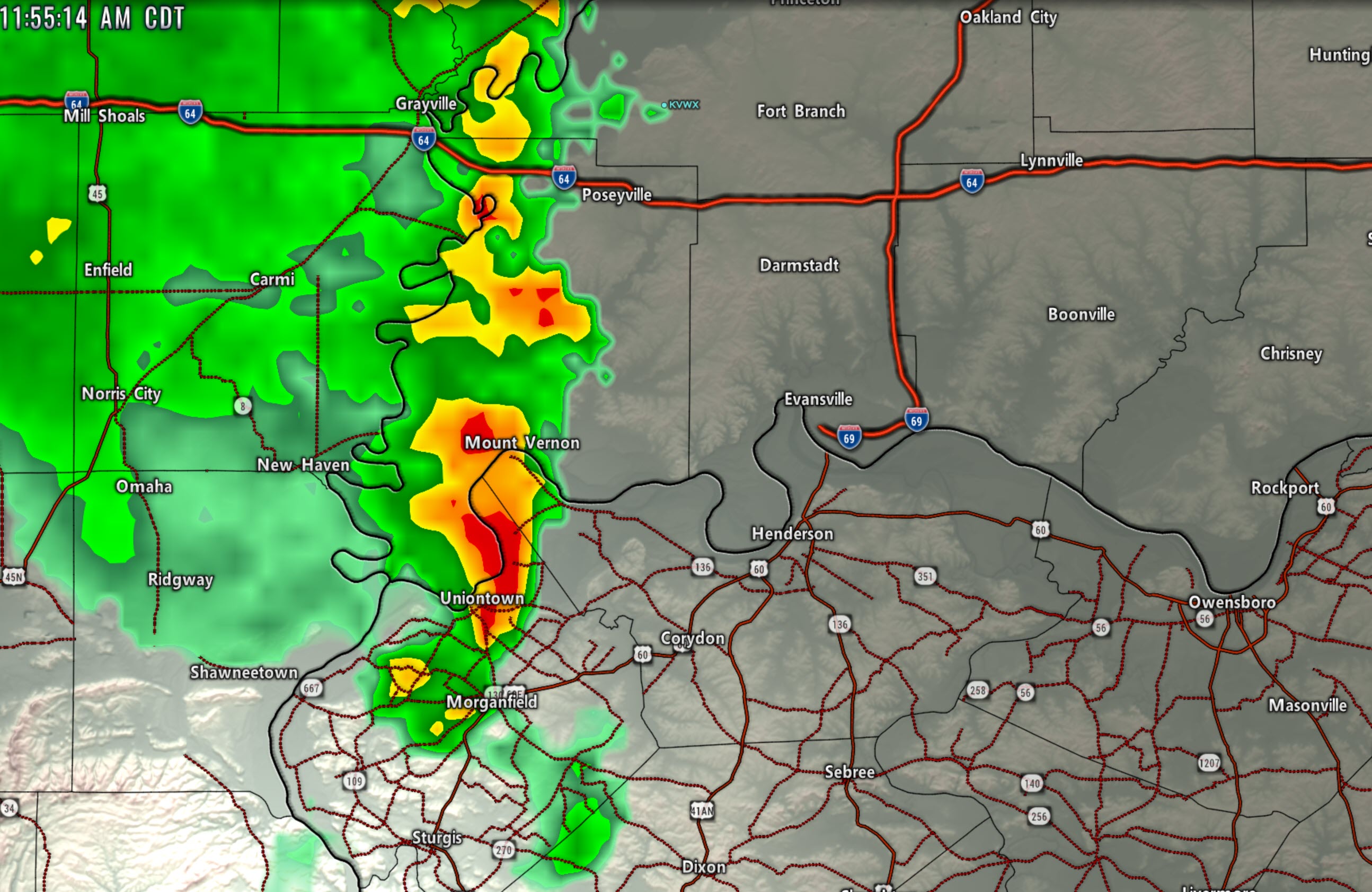
.
5:53 PM
PAH issues Severe Thunderstorm Warning [tornado: POSSIBLE, wind: 70 MPH, hail: 1.00 IN] for Daviess, Henderson, Hopkins, McLean, Muhlenberg, Union [KY] and Posey, Spencer, Warrick [IN] till 6:45 PM CDT
PAH continues Tornado Warning [tornado: RADAR INDICATED, hail: <.75 IN] for Caldwell, Crittenden, Hopkins, Union, Webster [KY] till 6:00 PM CDT ...AT 552 PM CDT, A SEVERE THUNDERSTORM CAPABLE OF PRODUCING A TORNADO WAS LOCATED OVER DIXON, OR NEAR PROVIDENCE, MOVING EAST AT 50 MPH.
.
5:51 PM
Trigg, Caldwell, Hopkins, Christian Storms have a long history of wind damage. Winds of 60 to 100+ MPH. These are dangerous storms. Seek shelter until the line passes. Brief tornadoes possible
5:52 PM Hopkins & Christian Storms are entering your area. Be prepared for pockets of wind damage. Power outages.
.
5:42 PM
Webster and Hopkins. Very high winds approaching Providence, KY. Blackford, Clay, Lisman, Nebo, KY.
.
5:34 PM
Radar shows a poss tornado moving NE at 50 mph. It was near Marion, KY. Other areas of very high damaging winds along the line of storms. Moving NE 50 mph. Shelter from these storms.
.
5:29 PM
5:29 PM Crittenden, Webster, Caldwell, Hopkins. VERY high winds on radar nearing Marion, KY moving towards Shady Grove. Shetler now. 100+ mph winds possible. Dangerous storm.
.
5:27 PM
Caldwell. Very high winds on radar near Fredonia moving NE. Everyone in the path of these storms should shelter till they pass. Be aware of brief tornadoes.
.
5:24 PM
Lyon and Caldwell. Rotation passing over LBL into Confederate KY area. Very rural area moving NE at 50 mph. Seek shelter till storms pass.
.
5:22 PM
A possible tornado and 110 mph winds moving near Smithland KY moving towards Sheridan and Marion, KY. Shelter immediately. This is a dangerous storm with a history of damage.
.
5:19 PM
Tornado Warning [tornado: RADAR INDICATED, hail: <.75 IN] for Crittenden, Livingston [KY] and Hardin [IL] till 5:45 PM CDT ...AT 519 PM CDT, A SEVERE THUNDERSTORM CAPABLE OF PRODUCING A TORNADO WAS LOCATED NEAR SALEM, OR 12 MILES WEST OF MARION, MOVING NORTHEAST AT 45 MPH.
.
5:18 PM
Crittenden County. VERY high winds entering your county. A large area. Shelter now as storms move NE at 45 mph.
.
5:15 PM
Possible tornado in or near Moors. South of Grand Rivers. Moving into LBL. Shelter now.
.
5:13 PM
A second poss tornado moving towards Burna, Salem, Dycusburg, KY. Shelter right now. NE of there shelter, as well. Movement is NE at 50 mph.
5:10 PM
Briensburg, KY Marshall County. A report of a tornado. Moving NE at 50 MPH. Shelter now. This is north of Benton and moving NE at 50 mph.
.
5:03 PM
Smithland shelter right now. Calvert City shelter right now. In and near these areas shelter. 100 MPH wind possible in and near these towns.
.
4:58 PM
Tornado has moved out of McCracken and is now heading across the river into south Pope and then towards Smithland, KY. Shelter immediately.
4:57
Radar shows two poss tornadoes. One near Brookport and another just south or near downtown Paducah. Moving NE 45 mph. Shelter now. Treat this as a tornado.
.
4:55 PM
Weaker rotation now. It is 5 miles west of Benton, KY. It will soon exit Graves County and enter Marshall. This is not the same rotation that is now over top Paducah.
.
4:53 PM
Tornado Warning [tornado: RADAR INDICATED, hail: <.75 IN] for Livingston, McCracken [KY] and Massac [IL] till 5:15 PM CDT ...AT 452 PM CDT, A SEVERE THUNDERSTORM CAPABLE OF PRODUCING A TORNADO WAS LOCATED OVER PADUCAH, MOVING NORTHEAST AT 50 MPH.
4:51 PM
Radar shows rotation NE of Lone Oak moving NE at 45. Moving towards Paducah/Woodlawn area. Shelter. I can not tell if it is on the ground or not.
.
4:50 PM
Graves. Rotation is near Hickory and Viola moving northeast at 45 MPH. Seek shelter as it moves through.
.
4:47 PM
Ballard and Carlisle you are in the clear now.
.
4:44 PM
Tornado Warning [tornado: RADAR INDICATED, hail: <.75 IN] for Ballard, Graves, Livingston, McCracken [KY] and Massac [IL] till 5:15 PM CDT ...AT 442 PM CDT, A SEVERE THUNDERSTORM CAPABLE OF PRODUCING A TORNADO WAS LOCATED NEAR LONE OAK, MOVING NORTHEAST AT 50 MPH.
.
4:42 PM
Tornado may be approaching Lone Oak and another NE of Fancy Farm, KY. Both moving NE at 45 mph. Treat this as a tornado on the ground.
.
4:34 PM
A second tornado is possible just west of Fancy Farm, KY entering Graves. Shelter now. Moving NE at 45 mph
.
4:32 PM
Radar shows a possible tornado entering SW McCracken County. Seek shelter. Storms are also producing high winds elsewhere.
.
4:30 PM
Ballard and McCracken. Radar shows higher winds expanding now. Winds of 55+ are likely.
..
4:27 PM
.Ballard Radar shows high winds about to enter southern Ballard near or south of Blandville moving E NE at 45 mph.
.
4:24 PM
Carlisle. Radar is showing high winds near Bardwell. Some weak rotation, as well. That storm may produce some wind damage as it moves E NE at 45 mph.
..
4:21 PM
Radar has shown some downward trend in wind speeds. There are small pockets of 60 mph winds embedded within the storms. Continue to be aware.
..
4:12 PM
I am receiving reports of trees and power lines/poles down in the Bootheel. The storms are moving east at 40 mph. Some wind damage may continue as they move east. Be aware.
..
4:10 PM
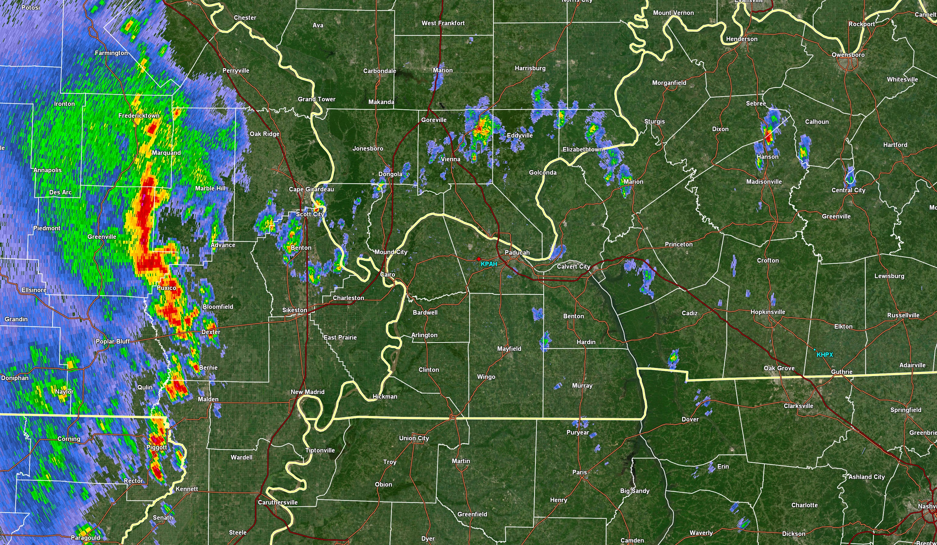
Severe Thunderstorm Warning [wind: 60 MPH, hail: <.75 IN] for Crockett, Dyer, Gibson, Haywood, Lake, Lauderdale, Obion, Tipton [TN] and Pemiscot [MO] and Mississippi [AR] till 5:00 PM CDT
Strongest wind signatures are coming out of New Madrid County, MO moving east.
..
4:09 PM
Expires Tornado Warning for Mississippi [MO] and Alexander, Pulaski [IL]
.
4:06 PM
Alexander/Pulaski. Circulations have weakened. High winds are still possible. Be aware.
Tornado Warning [tornado: RADAR INDICATED, hail: <.75 IN] for Mississippi [MO] and Alexander, Pulaski [IL] till 4:15 PM CDT ...AT 401 PM CDT, A SEVERE THUNDERSTORM CAPABLE OF PRODUCING A TORNADO WAS LOCATED NEAR MOUNDS, OR 10 MILES NORTH OF CAIRO, MOVING NORTHEAST AT 55 MPH.
.
4:01 PM
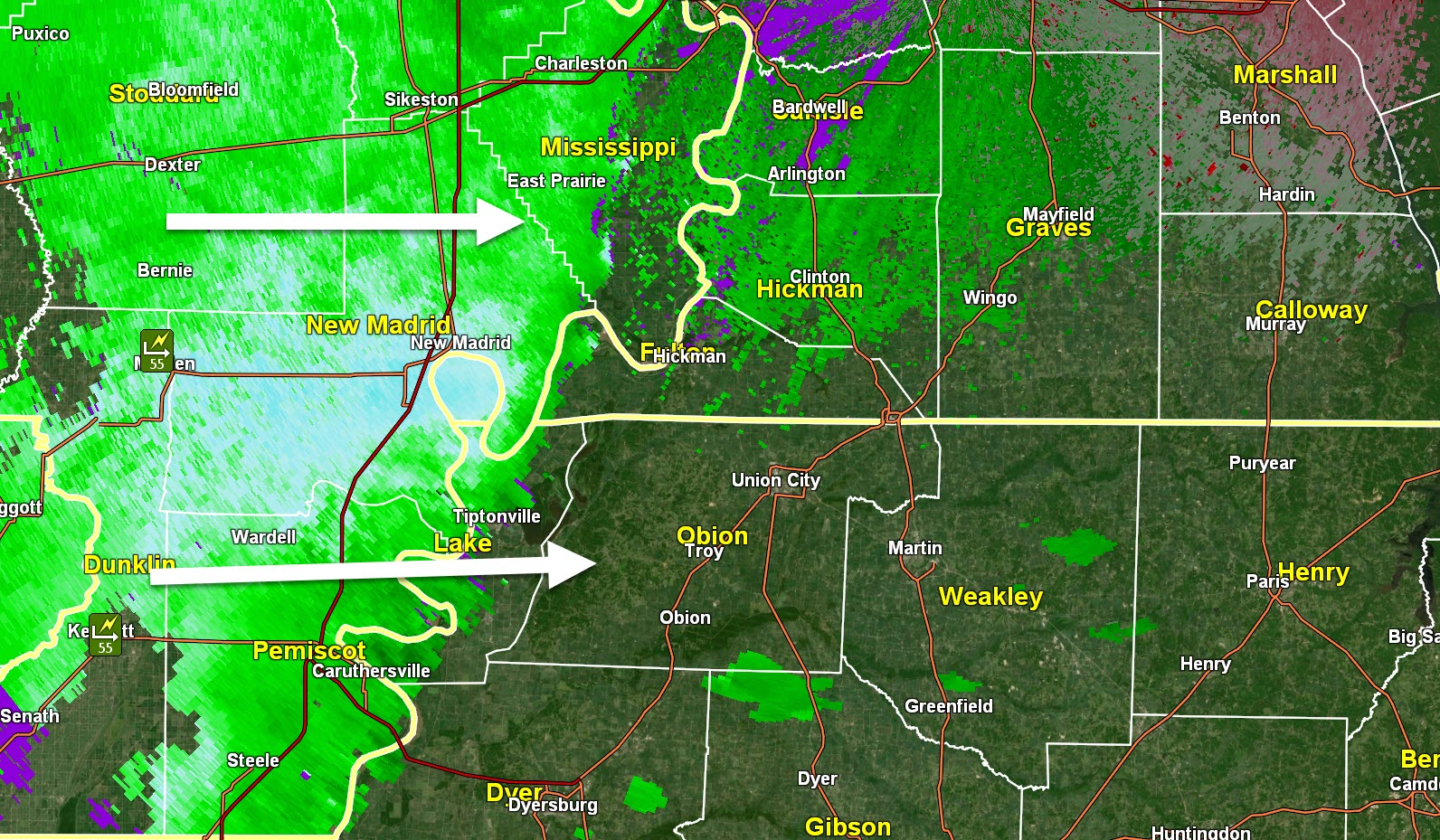
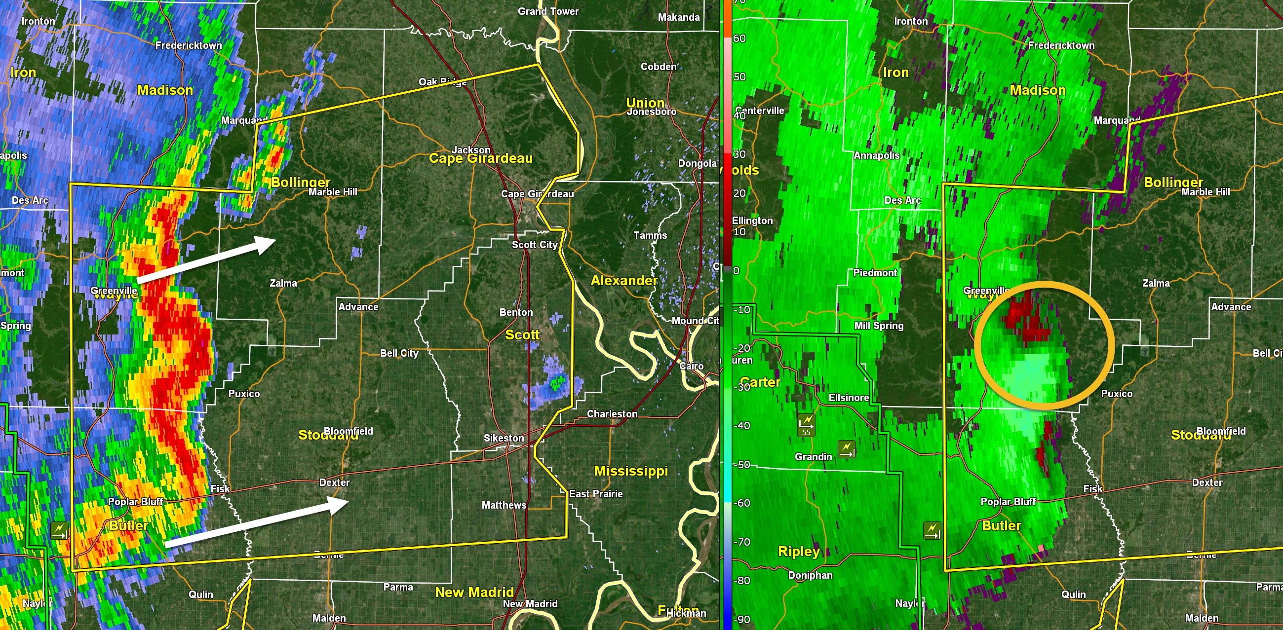
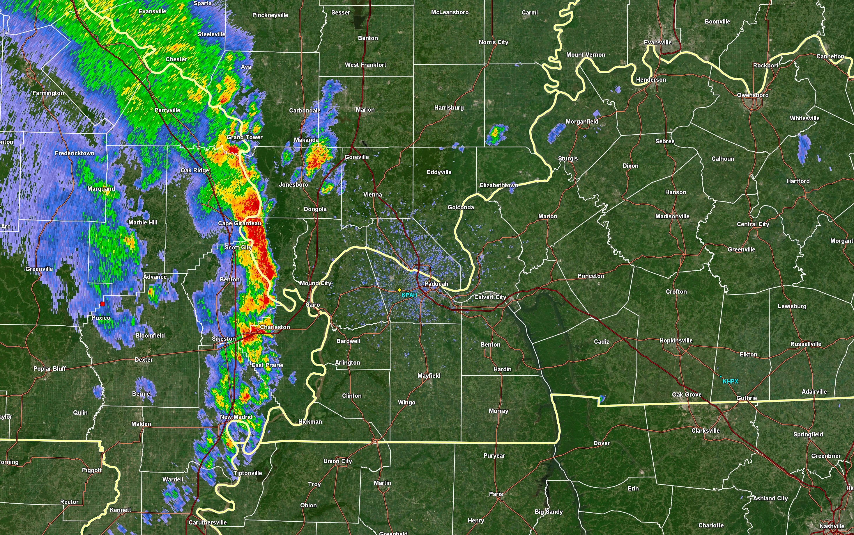
New Madrid, southern MS, Fulton County, Lake & Obion. Perhaps Hickman County. Radar shows 50 to 60+ mph winds moving through or into your area. Tree damage likely in the core of these winds.
Bluish colors are high winds
Click to enlarge.
.
3:53 PM
Mississippi County. Storms moving into your county now could have 55 to 60 mph winds gusts. Very heavy rain.
.
3:47 PM
Tornado Warning [tornado: RADAR INDICATED, hail: <.75 IN] for Cape Girardeau, Scott [MO] and Alexander, Pulaski [IL] till 4:00 PM CDT ...AT 345 PM CDT, A SEVERE THUNDERSTORM CAPABLE OF PRODUCING A TORNADO WAS LOCATED NEAR SCOTT CITY, MOVING EAST AT 40 MPH.
.
3:47 PM
Pope, Livingston, Marshall, Calloway. Be alert storms will move into your area later this afternoon. Still more than an hour out. They could cause wind damage. Campers/others be alert.
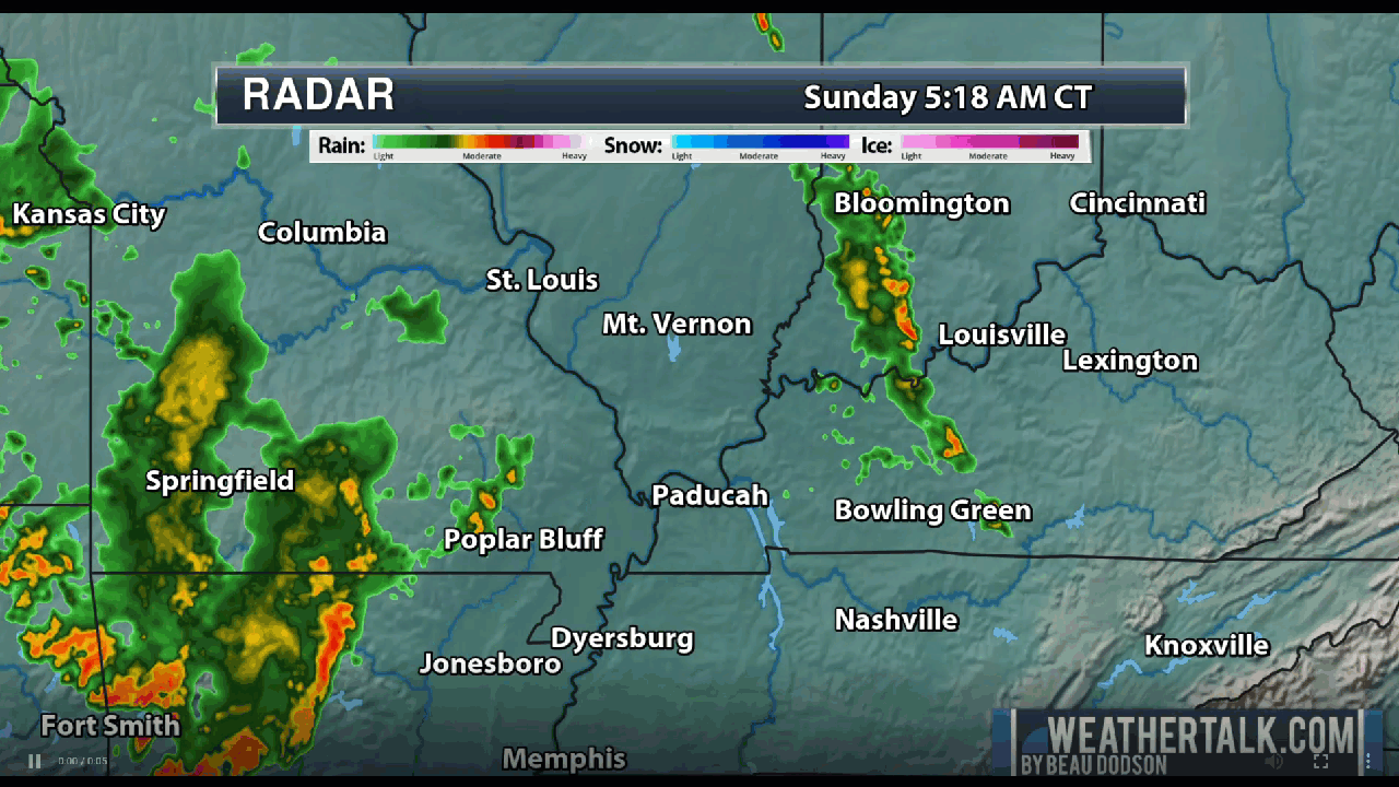
Live radars
Radar Link: Interactive local city-view radars & regional radars.
.
3:45 PM
Obion, Weakley, and Henry. Be prepared. Storms are approaching from the west. Some wind damage is possible if they maintain their strength. They are still about 30 to 60 minutes out (a bit longer perhaps for Henry).
.
3:45 PM
.
3:44 PM
Tornado Warning [tornado: RADAR INDICATED, hail: <.75 IN] for Mississippi, Scott [MO] and Alexander, Pulaski, Union [IL] till 4:15 PM CDT ...AT 343 PM CDT, A SEVERE THUNDERSTORM CAPABLE OF PRODUCING A TORNADO WAS LOCATED NEAR BENTON, MOVING NORTHEAST AT 45 MPH.
3:42 PM
Scott and Alexander. Strong rotation east of Morley, MO. Moving E and slightly NE at 50 mph. Seek shelter. A tornado is possible with this storm. It will soon cross the river into Alexander County.
.
3:38 PM
Johnson, Massac, McCracken, Graves. A line of intense storms is approaching from the west over the coming hour. Wind damage is poss. Hail is poss. These storms have produced short lived circulations. Be aware.
.
3:33 PM
.Scott County Radar shows a possible tornado east of Vanduser, MO. Anyone in and near these areas should seek shelter now.
Radar Link: Interactive local city-view radars & regional radars.
.
3:32 PM
Ballard, Carlisle, Hickman. A line of storms with a history of wind damage is approaching from the west. Winds above 60 mph are poss. Hail, as well. Be alert for short-lived tornadoes, as well.
.
3:31 PM
Severe Thunderstorm Warning [wind: 60 MPH, hail: 0.88 IN] for Cape Girardeau, Mississippi, New Madrid, Scott, Stoddard [MO] and Ballard, Carlisle, Fulton, Hickman [KY] and Alexander, Johnson, Pulaski, Union [IL] till 4:30 PM CDT
.
3:30 PM
Union County, IL. Storms approaching from the SW. The storms could produce wind damage. Be aware as storms approach.
.
3:28 PM
I am tracking multiple areas of rotation in southern Cape G County, Stoddard, & Scott Counties. Movement E NE at 50 mph. Seek shelter as storms move through your area. Hail possible.
.
3:24 PM
Alexander & Pulaski. Be alert. Radar shows a possible tornado near Chaffee moving east at 40 to 50 mph. Very high winds are likely, as well. Hail is possible. Prepare to shelter.
.
3:22 PM
Severe Thunderstorm Warning [tornado: POSSIBLE, wind: 60 MPH, hail: <.75 IN] for Bollinger, Cape Girardeau, New Madrid, Scott, Stoddard [MO] till 3:30 PM CDT
.
3:21 PM
Dunklin, Pemiscot, New Madrid, Fulton, Lake, and Obion.
A line of storms moving through Dunklin County. Movement east at 45 mph. There has been a history of trees down and power outages. Counties to the east be alert.
.
3:19 PM
Southern Cape G County. I am watching very high winds in your county. There could be a tornado as well near Delta or east of Delta. Moving E NE at 50 mph. Shelter.
.
3:17 PM
Northern Stoddard/Scott. Radar continues to show a possible tornado near Bell City moving E NE at 50 mph. Stay sheltered.
.
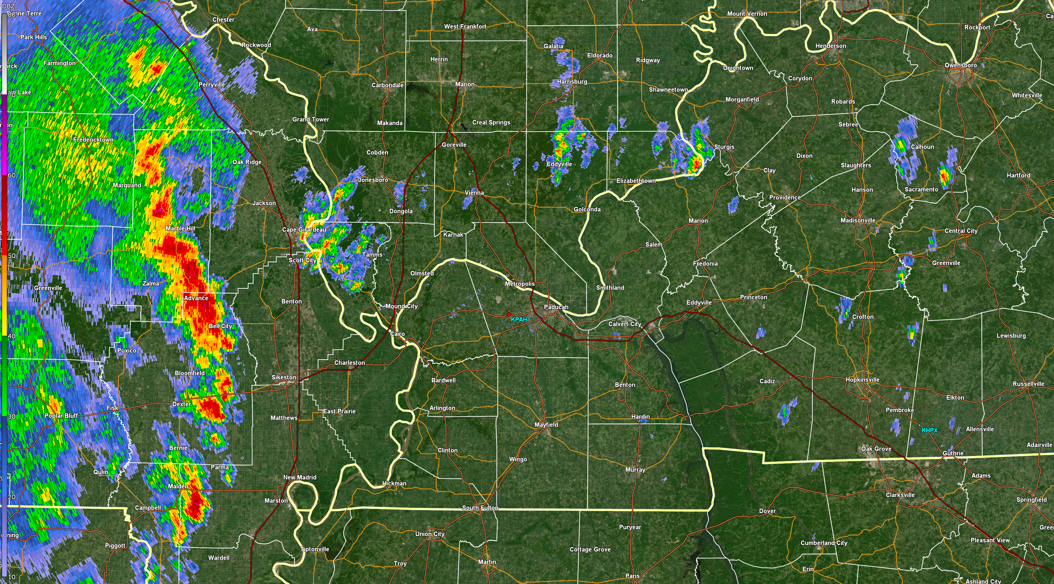
3:14 PM
Tornado Warning [tornado: RADAR INDICATED, hail: <.75 IN] for Scott, Stoddard [MO] till 3:45 PM CDT ...AT 314 PM CDT, A SEVERE THUNDERSTORM CAPABLE OF PRODUCING A TORNADO WAS LOCATED OVER BELL CITY, OR 8 MILES SOUTHEAST OF ADVANCE, MOVING EAST AT 50 MPH.
.
3:05 PM
I am tracking two areas of rotation. One NW of Advance, MO and one near or north of Bloomvield, MO. Moving east at 45 mph. Stay sheltered.
.
3:03 PM
Tornado Warning [tornado: RADAR INDICATED, hail: <.75 IN] for Bollinger, Stoddard, Wayne [MO] till 3:15 PM CDT ...AT 302 PM CDT, A SEVERE THUNDERSTORM CAPABLE OF PRODUCING A TORNADO WAS LOCATED 7 MILES SOUTHWEST OF LEOPOLD, OR 7 MILES NORTHWEST OF ADVANCE, MOVING NORTHEAST AT 40 MPH.
.
2:56 PM
Tornado warning in the red zone. Severe storm in the orange color.
Two tornadoes are possible.
We have damage reported from these storms. Movement is east at 45 mph.
Live radar
http://weatherobservatory.com/weather-radar.htm
.
2:52 PM
PAH issues Tornado Warning [tornado: RADAR INDICATED, hail: <.75 IN] for Stoddard [MO] till 3:30 PM CDT ...AT 252 PM CDT, A SEVERE THUNDERSTORM CAPABLE OF PRODUCING A TORNADO WAS LOCATED NEAR DUDLEY, OR 8 MILES NORTHWEST OF DEXTER, MOVING EAST AT 45 MPH.
.
2:51 PM
Radar shows a possible tornado near Zalma and another W/NW of Dexter by about six miles. Movement is east at 45 mph
2:50 PM
Stoddard
A tornado is possible west of Dexter, MO. Moving east at 45 mph.
.
2:48 PM
2:47 PM
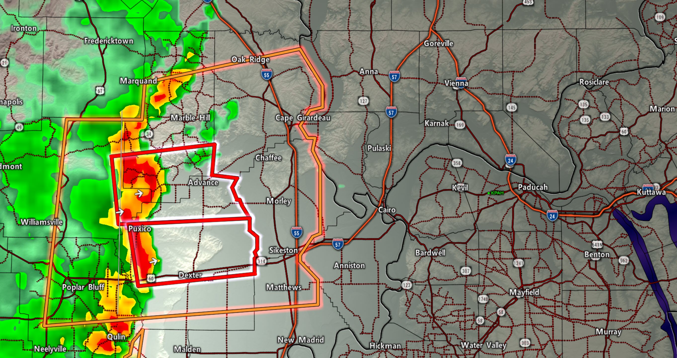
NWS Tornado Warning [tornado: RADAR INDICATED, hail: <.75 IN] for Bollinger, Stoddard, Wayne [MO] till 3:15 PM CDT ...AT 246 PM CDT, A SEVERE THUNDERSTORM CAPABLE OF PRODUCING A TORNADO WAS LOCATED 8 MILES NORTH OF PUXICO, OR 13 MILES NORTHEAST OF LAKE WAPPAPELLO STATE PARK, MOVING EAST AT 50 MPH.
.
2:46 PM
Bollinger. Another area of rotation W NW of Zalma moving E NE at 45 mph. Be alert and ready to shelter.
.
2:44 PM
Southern Bollinger/northern Stoddard. A storm with rotation is approaching. It will soon be between Puxico and Zalma. Moving E NE at 45. This storm could produce a tornado.
.
2:40 PM
2:36 PM
Dunklin and Pemiscot. Line of storms is approaching from the west. These storms have a history of high winds. Be aware as storms approach.
.
2:33 PM
Southeast Missouri. Storms could have small brief circulations at the leading edge. Be prepared to seek shelter even if there is not a tornado warning.
.
2:30 PM
Trees down on house and cars on CR 461 West of Poplar Bluff
.
2:29 PM
Bollinger, Cape G, Stoddard, Scott, New Madrid, Mississippi Storms are approaching from the west with a history of wind damage. Be aware as they approach over the coming hour.
.
2:19 PM
Daviess County. The intense storm continues. Hail is possible and wind damage. Flash flooding is a concern.
.
2:12 PM
Radar Link: Interactive local city-view radars & regional radars.
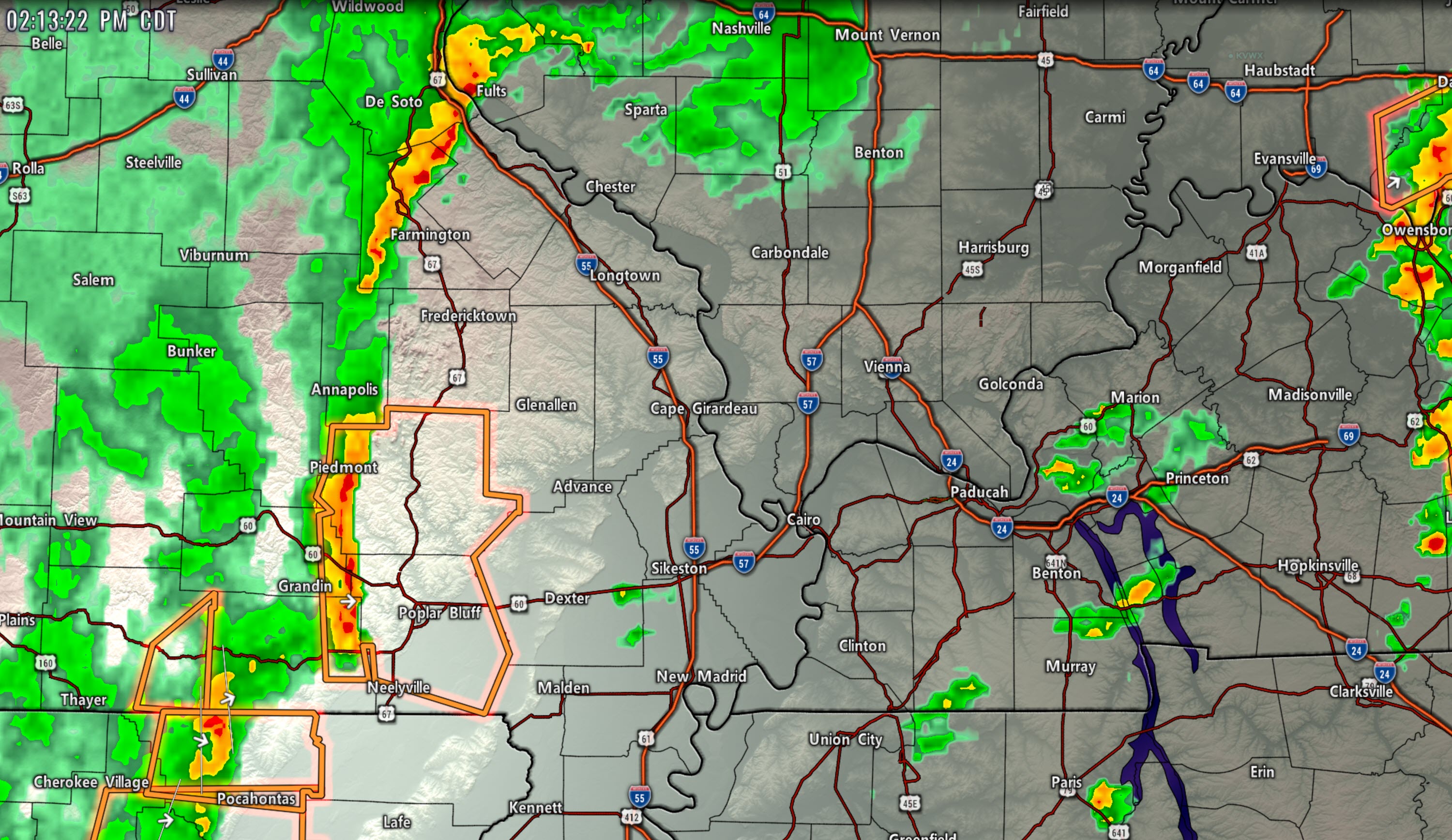
Severe Thunderstorm Warning [tornado: POSSIBLE, wind: 60 MPH, hail: 0.75 IN] for Butler, Carter, Ripley, Wayne [MO] till 2:30 PM CDT
.
2:07 PM
My deepest apology. The power outage did something to our app system. We just got it running. We did not know it was down. The app/text messages are working again.
.
2:06 PM
Tornado warning has expired.
.
2:02 PM
Marshall and Calloway. The rotation is very weak. Monitor as storms move through your area.
.
2:00 PM
St Genevieve, Perry County MO, Randolph County, IL. A line of storms is moving into your area from the west. The line could produce pockets of 50+ mph wind gusts. Be aware. Storms are moving E NE at 45 mph..
.
1:57 PM
Butler. A line of storms is approaching from the west. This line could produce pockets of 55 mph wind gusts. Be aware as it moves east at 45 mph.
.
1:44 PM
Rotation is now near Tri City and Cooksville in far SE Graves County moving E NE at 45. The rotation is not strong but it is there. Seek shelter.
.
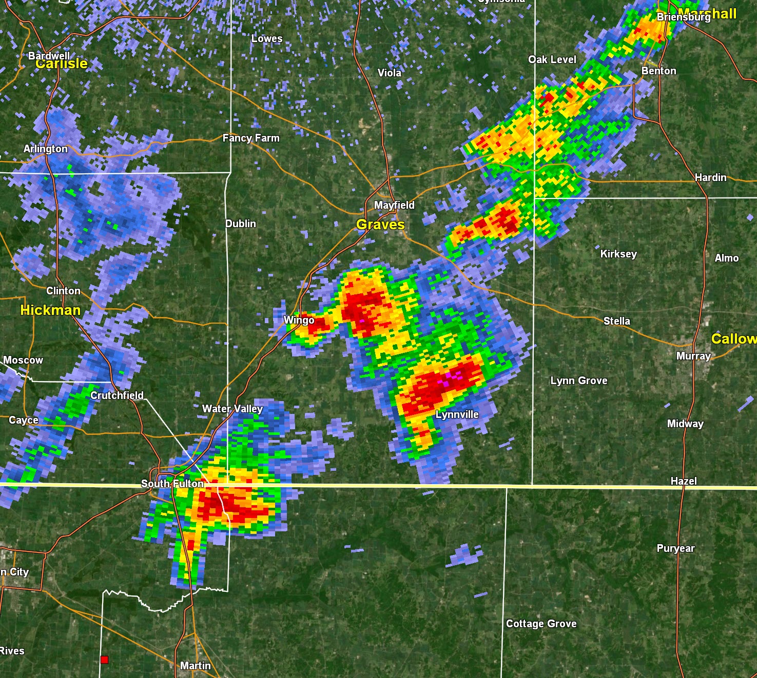
1:37 PM
Graves. Rotation is now over Lynnville, KY. A tornado is possible. It is radar indicated. The signature is not strong but it is rotating. Be aware. Moving E NE at 45 mph.
.
1:37 PM
Daviess, McLean, Muhlenburg. Heavy storms could cause pockets of wind damage and flash flooding. Hail is also possible. Storms moving NE at 45 mph.
.
1:36 PM
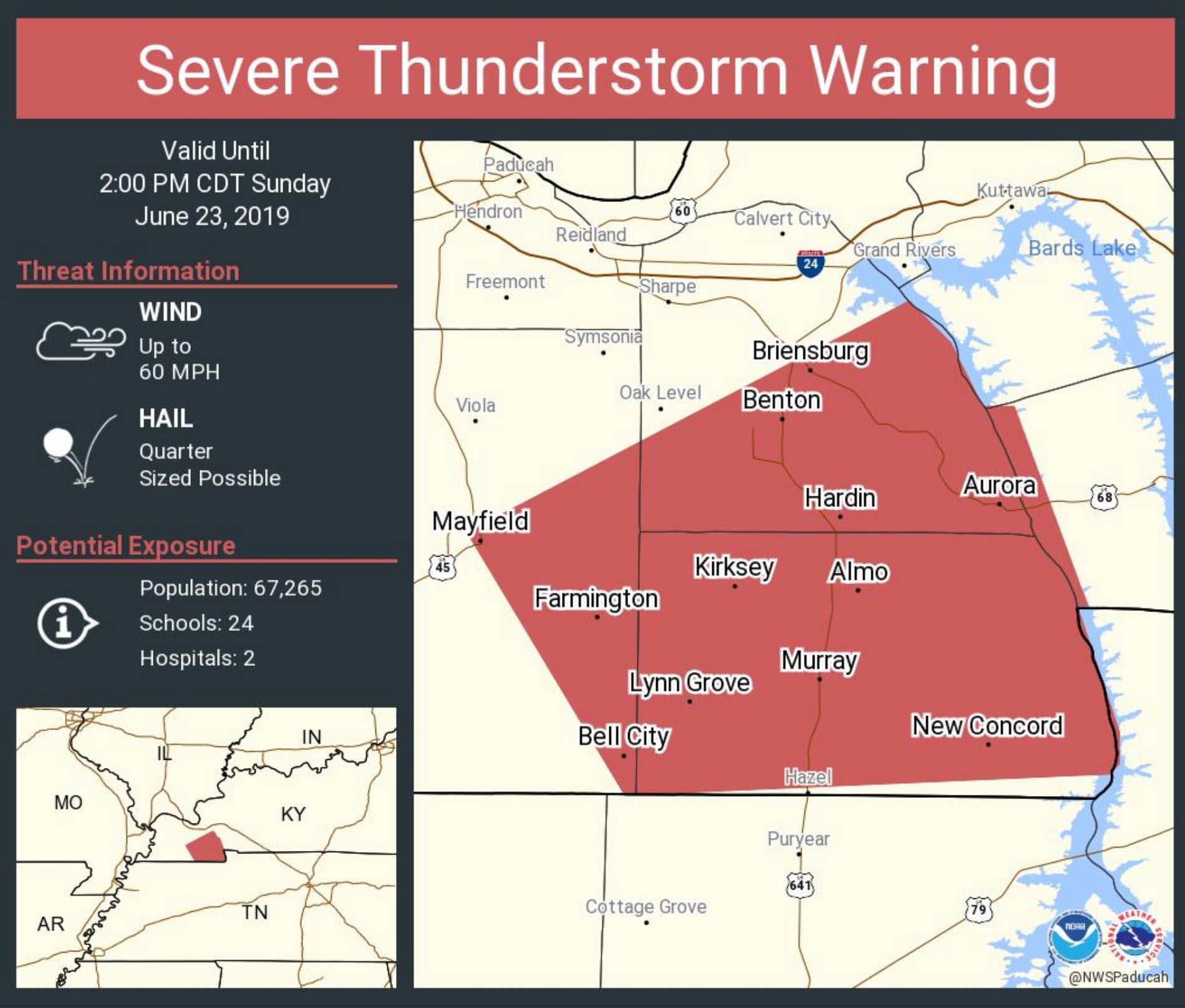
PAH continues Tornado Warning [tornado: RADAR INDICATED, hail: 1.50 IN] for Graves [KY] till 2:00 PM CDT ...AT 134 PM CDT, A SEVERE THUNDERSTORM CAPABLE OF PRODUCING A TORNADO WAS LOCATED OVER LYNNVILLE, OR 12 MILES SOUTH OF MAYFIELD, MOVING NORTHEAST AT 25 MPH.
.
1:34 PM
There is zero concern for the City of Mayfield. The storm is well southeast of you.
.
1:28 PM
Tornado Warning [tornado: RADAR INDICATED, hail: 1.50 IN] for Graves [KY] till 2:00 PM CDT ...AT 126 PM CDT, A SEVERE THUNDERSTORM CAPABLE OF PRODUCING A TORNADO WAS LOCATED NEAR LYNNVILLE, OR 13 MILES EAST OF FULTON, MOVING NORTHEAST AT 25 MPH.
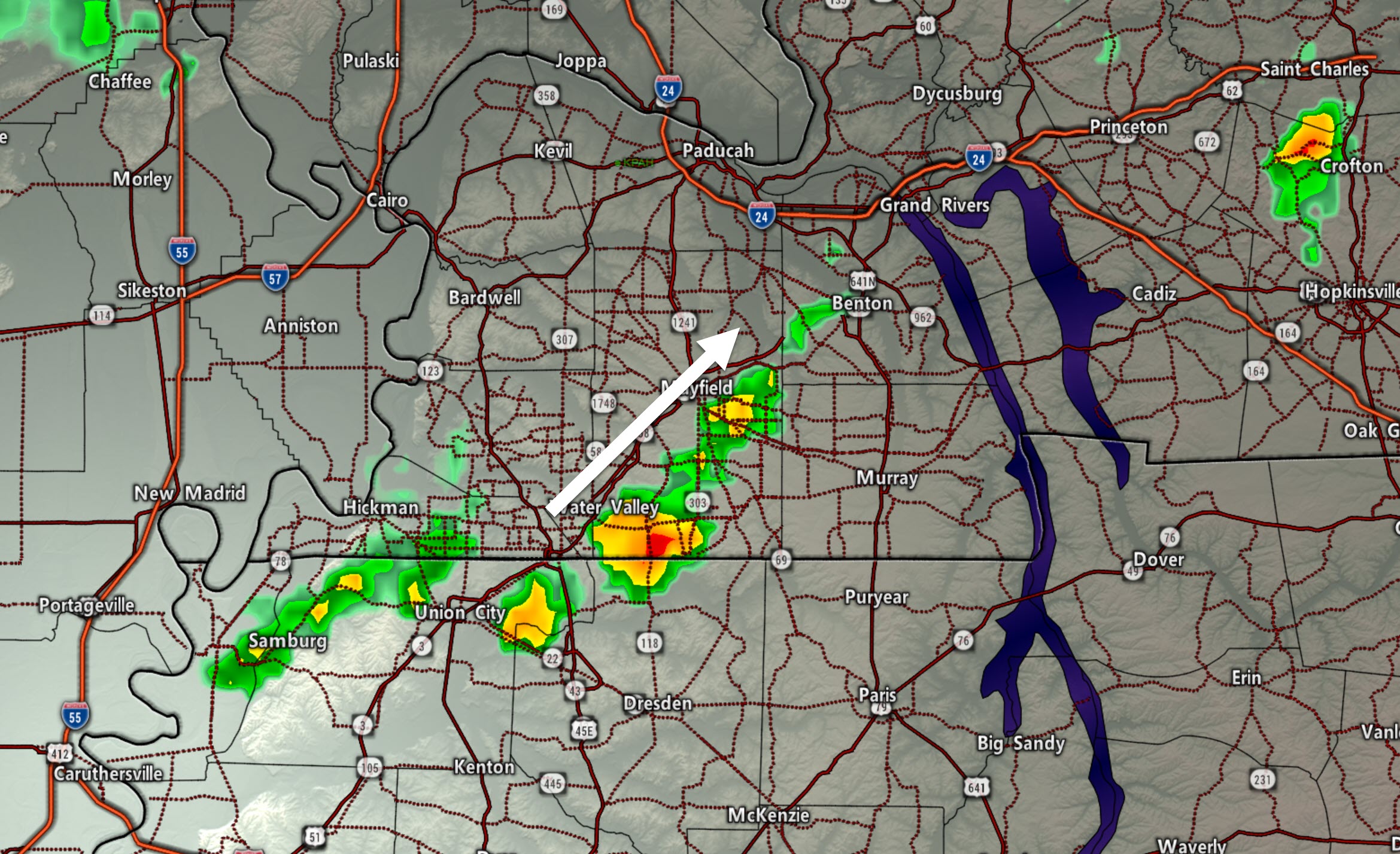
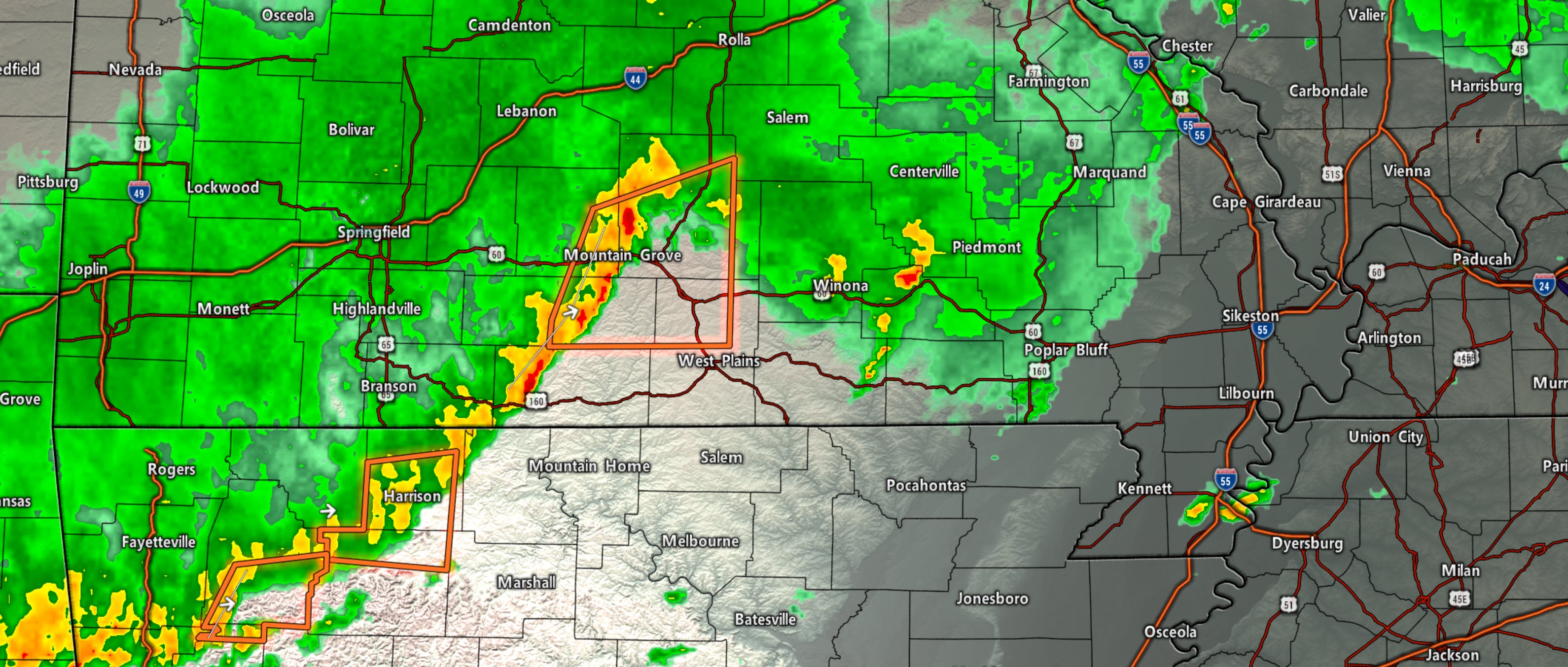
Radar shows rotation in SE Graves County moving NE at 45 mph. Seek shelter. It is SW of Lynnville, KY.
.
1:25 PM
Radar
Red boxes are severe thunderstorm warnings.
Radar Link: Interactive local city-view radars & regional radars.
.
1:24 PM
Southeast MO has become quite unstable. SPC severe weather parameter numbers indicate there may be several reports of severe weather including hail and wind. Low-end tornado risk, as well.
Same for NW TN and western KY.
.
1:19 PM
Severe Thunderstorm Warning [wind: 60 MPH, hail: 1.00 IN] for Calloway, Graves, Marshall, Trigg [KY] till 2:00 PM CDT
.
1:18 PM
1:07 PM
High winds on the radar just south of Mayfield. Wind estimate of 50+ mph. The storm is moving NE at 45 mph.
.
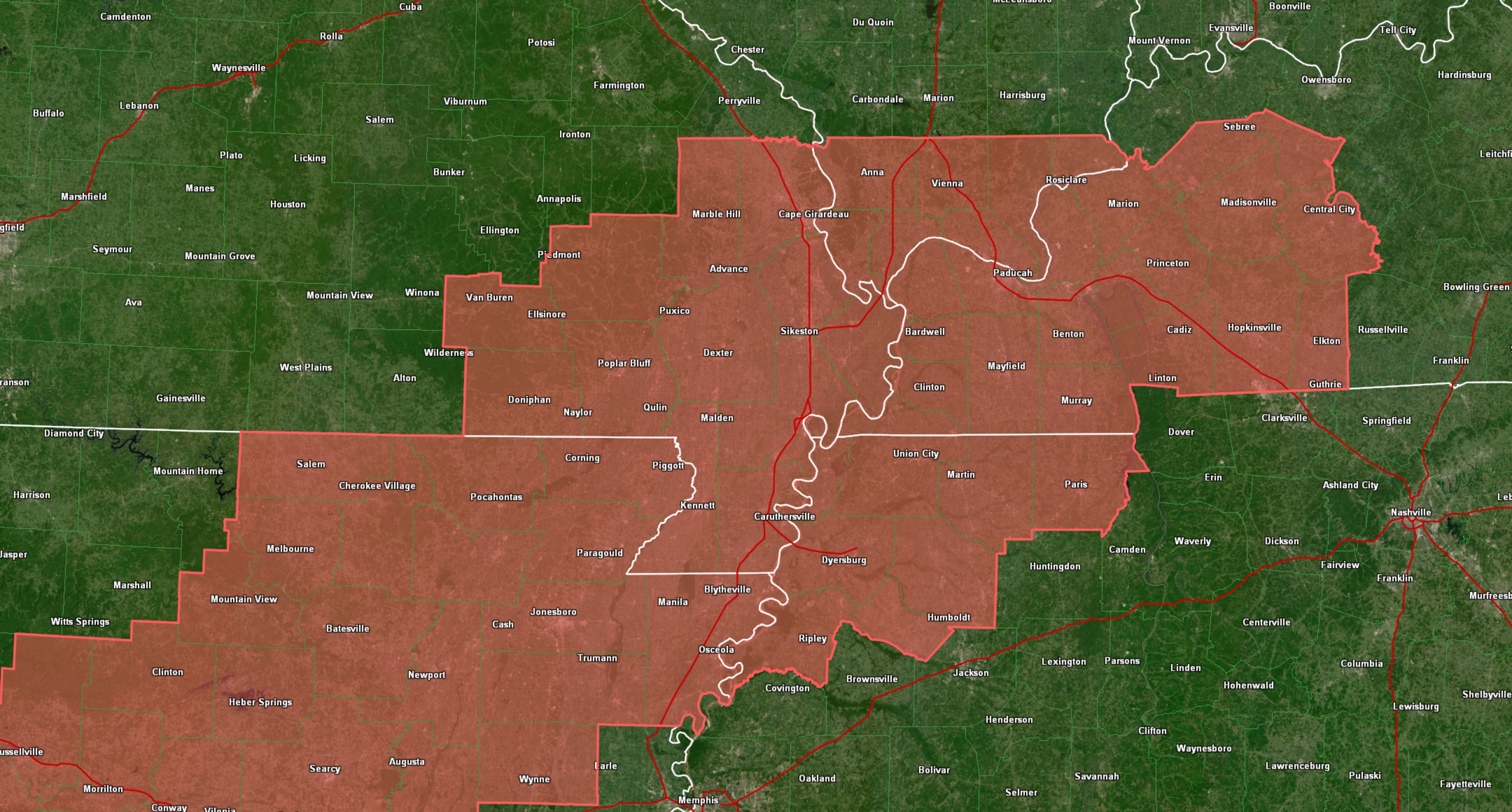
1:02 PM
A severe thunderstorm watch has been issued for the rest of the afternoon.
A few storms may produce hail and high winds. A low-end tornado risk.
The watch covers the red counties.
Remember, a watch means to monitor updates.
.
12:58 PM
SE Graves, W/NW Calloway, southern Marshall. I am tracking an intense storm in SE Graves County. Movement NE at 45 mph. It may produce isolated high wind and hail.
.
12:43 PM
Strong storms entering Graves County. Heavy rain and lightning. Pea size hail. Gusty winds.
Movement is NE.
Live radar here
http://weatherobservatory.com/radar_paducah.htm
.
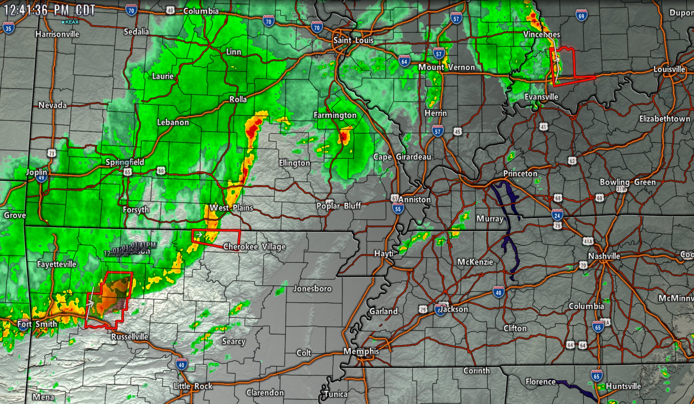
12:41 PM
Thunderstorms are developing along a line from central Missouri south and southwest into Arkansas.
Some of these storms are producing very heavy rain, lightning, and 50 mph wind gusts.
The storms are moving east/northeast at 45 mph.
These storms are going to enter southeast Missouri shortly. Some of them could produce high winds.
There are also a few storms over northwest Tennessee. They are not severe, at this time. Lightning is a concern as they move northeast at 40 mph.
Storms in southern Illinois are also below severe levels.
I am watching one thunderstorm in northern Madison County, Missouri, moving into Perry County, Missouri. This storm is producing torrential rain and lightning. It could also produce strong wind gusts.
The ground is saturated. It would not take much for trees to topple today.
12:37 PM
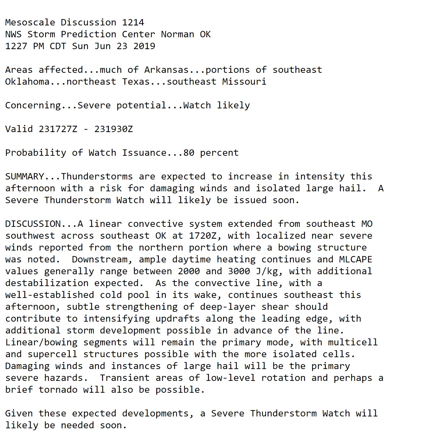
The Storm Prediction Center has now outlined an area for a possible severe thunderstorm watch.
80% chance of a watch being issued.
.
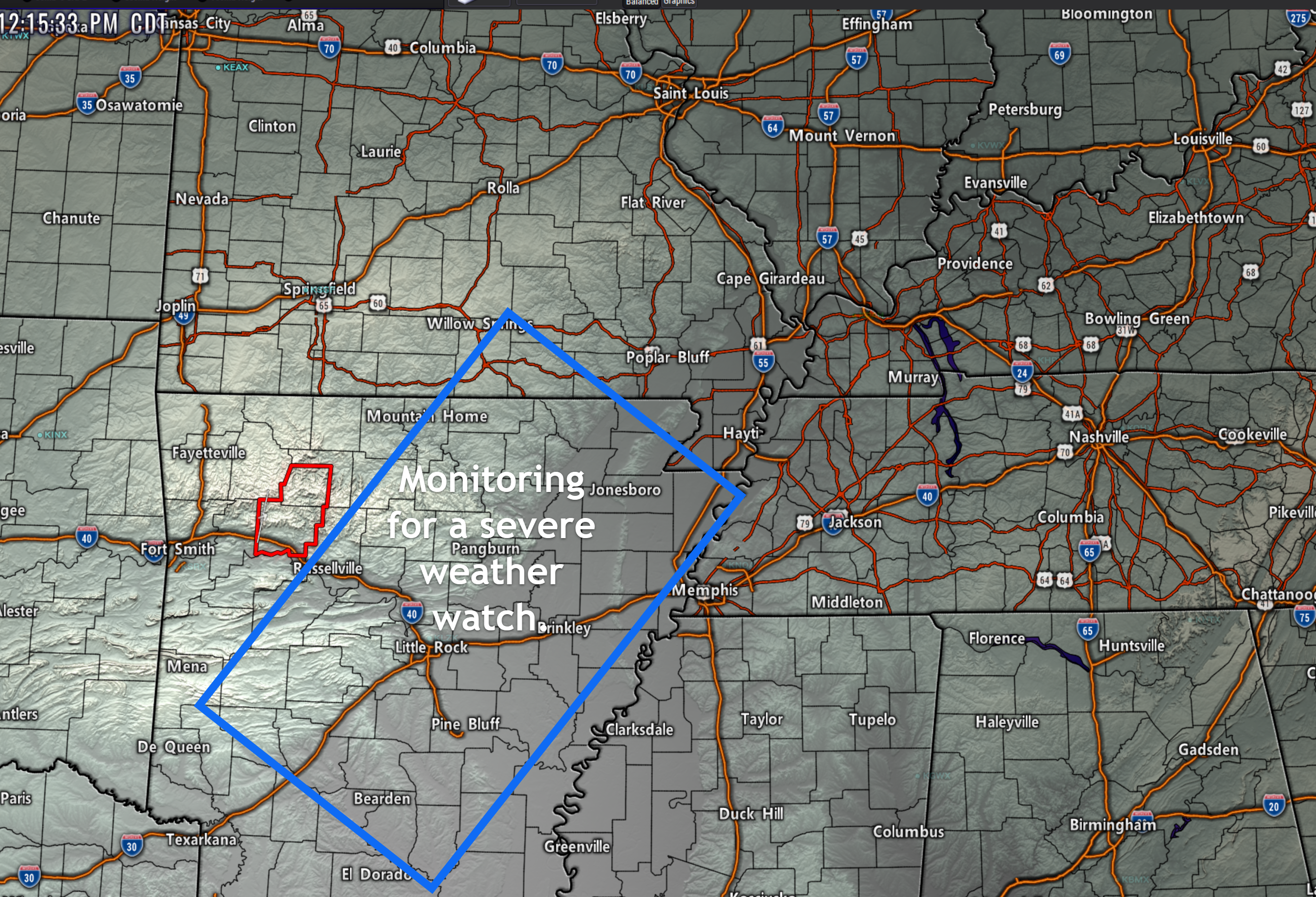
12:18 PM
I am monitoring this area for a possible severe weather watch. Let's keep an eye on the Missouri Bootheel and western Tennessee. Further northeast should monitor as we move deeper into the afternoon.
.
12:11 PM
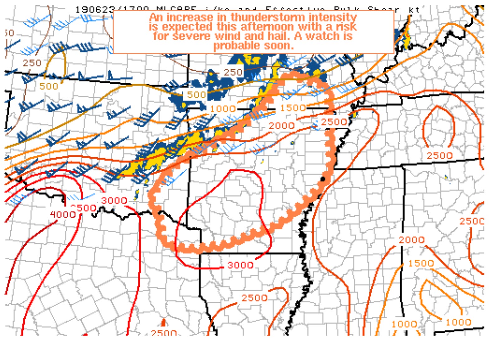
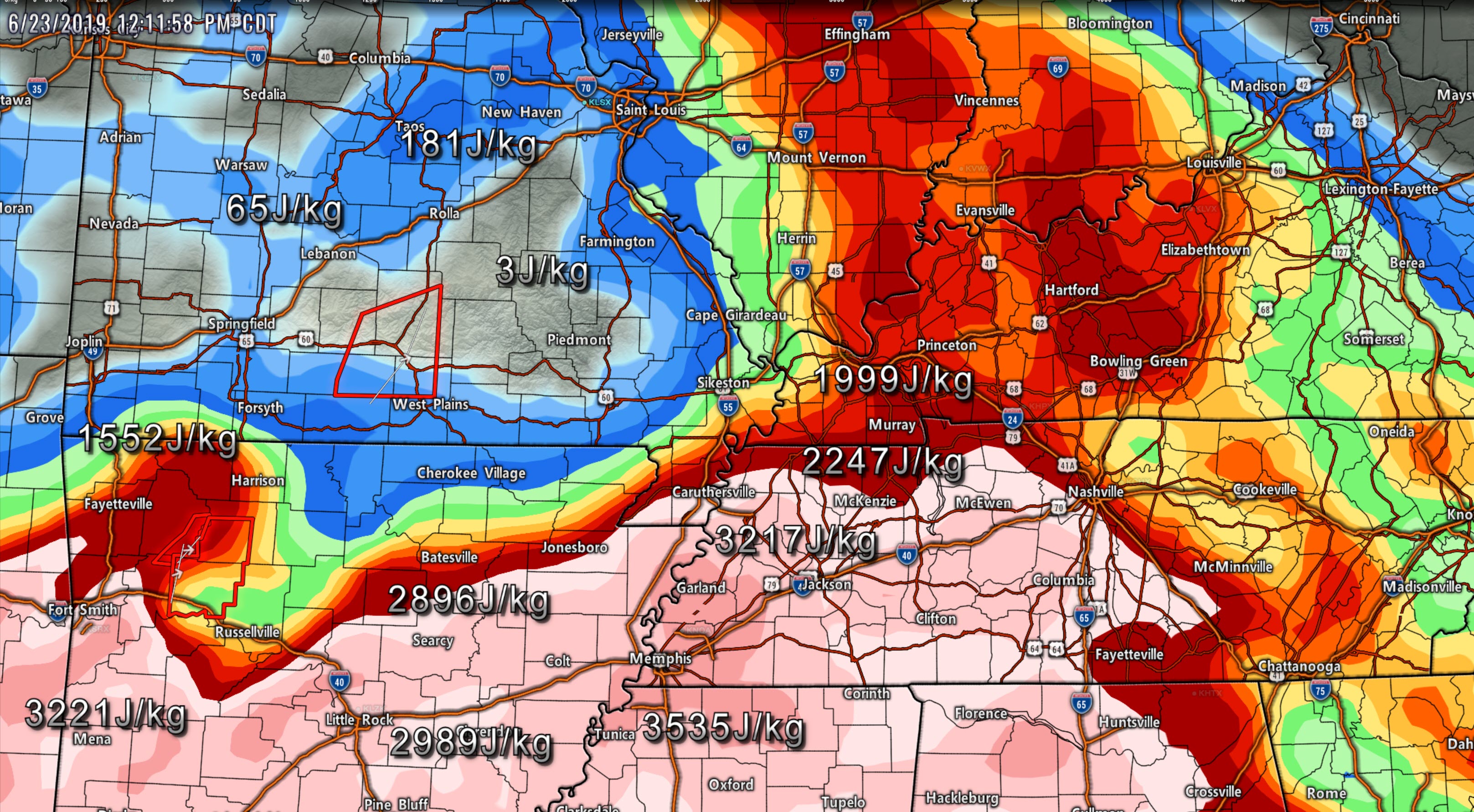
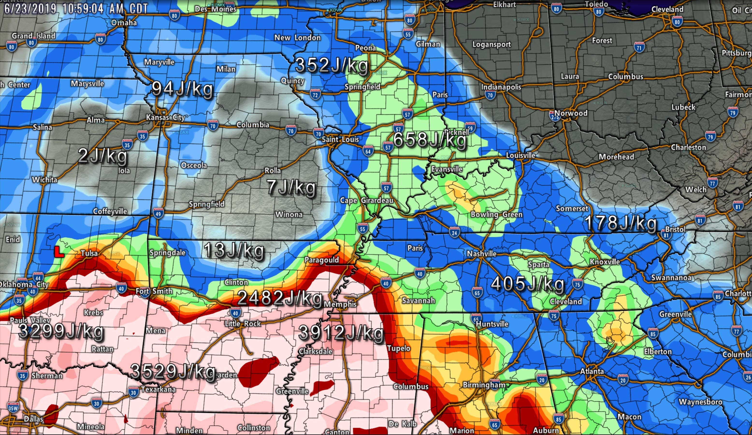
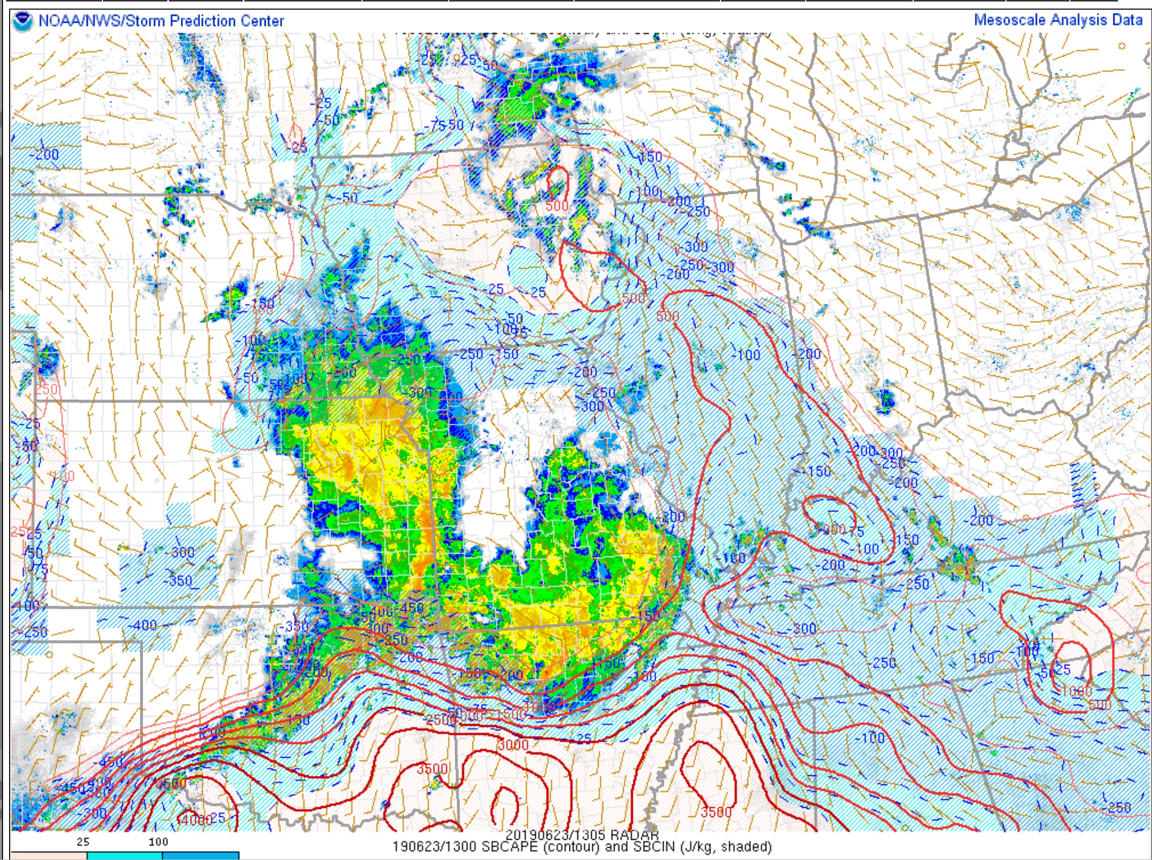
I am becoming a bit more concerned as CAPE is rising over the Bootheel of MO into portions of KY/TN.
Let's keep a close eye on the coming hours.
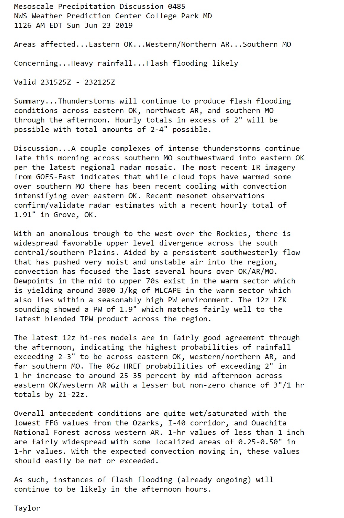
Here are the latest CAPE numbers.
Click to enlarge.
.
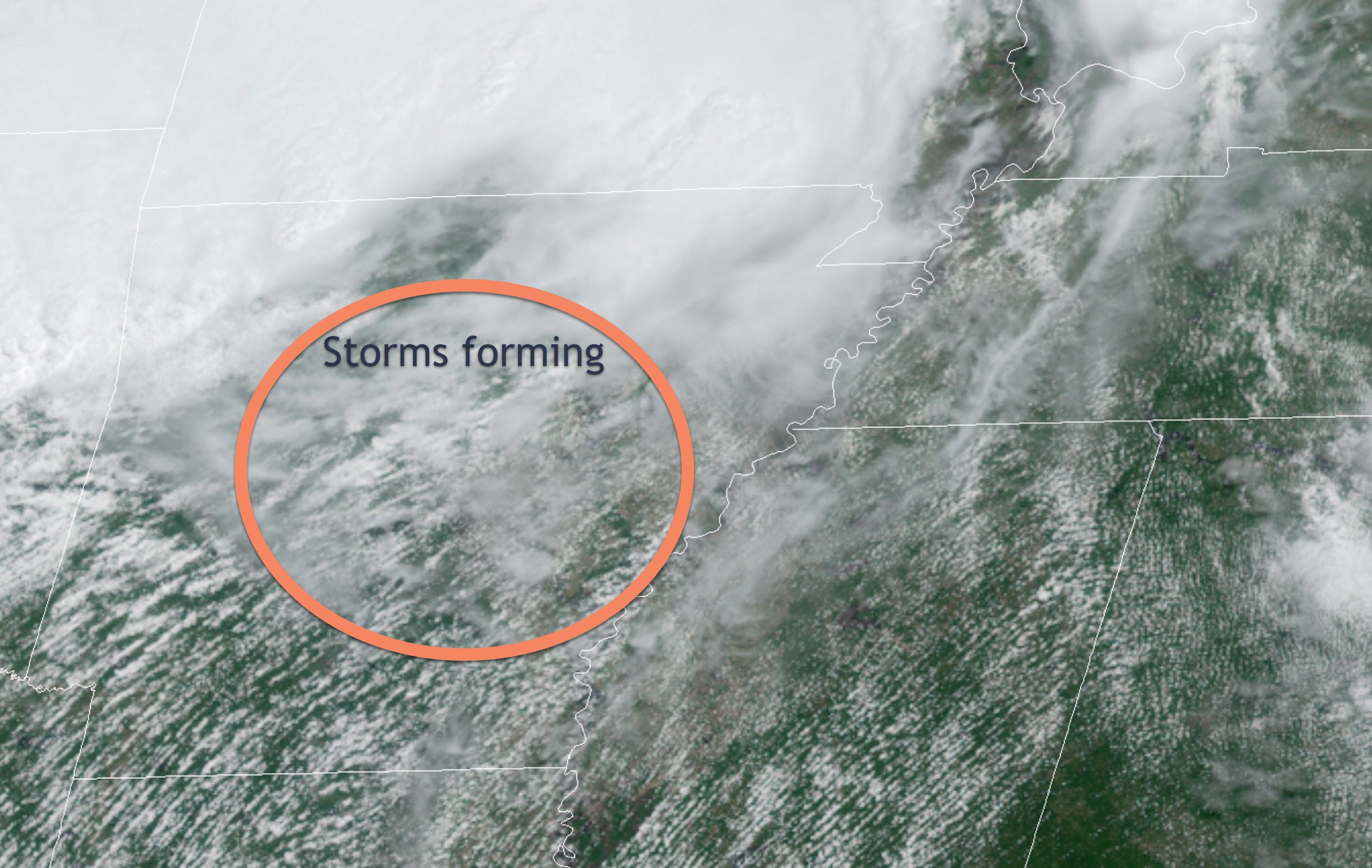
12:05 PM
I am watching thunderstorms forming north of Little Rock and moving northeast. These could become severe.
.
11:54 AM
Storms in NW KY could produce 30 to 45 mph wind gusts.
They are moving E NE at 40 mph
Radar Link: Interactive local city-view radars & regional radars.
.
11:45 AM
The Springfield, Missouri, NWS office has issued some warnings in southern Missouri. This is for high winds.
SPC downgraded a decent chunk of our region into a level one risk.
SPC put southern MO in general (no severe storms). There are severe storms in that area.
I am not a fan of the colors. Focus on the forecast and not the SPC colors.
The forecast is that a few storms today could produce wind damage. Let's monitor the coming hours.
There are a lot of thick clouds. That is definitely helping to keep CAPE numbers lower. CAPE is energy for storms to tap into.
.
10:53 AM
Here are some of my thoughts on the current satellite.
Remember, clearing and sun cause the atmosphere to become unstable.
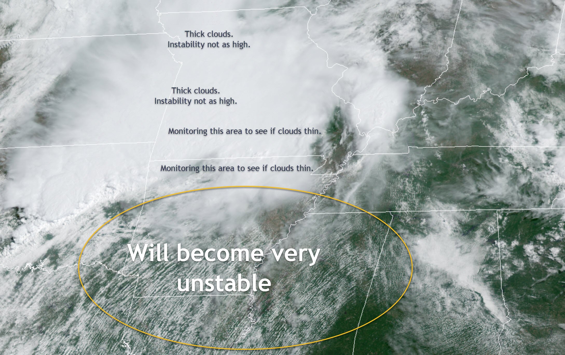
Notice how CAPE (in red) is much higher where the sun is shining.
.
10:52 AM
Here is a flash flood statement from NOAA.
Click images to enlarge (text, as well)
.
9:35 AM
Live radars
http://weatherobservatory.com/weather-radar.htm
.
9:03 AM
The ongoing clouds and storms may help our cause today. We do not clear out then the severe weather risk is lower than it could be.
.
9:00 AM
Approximate time. Give or take ten minutes.
.
8:50 AM
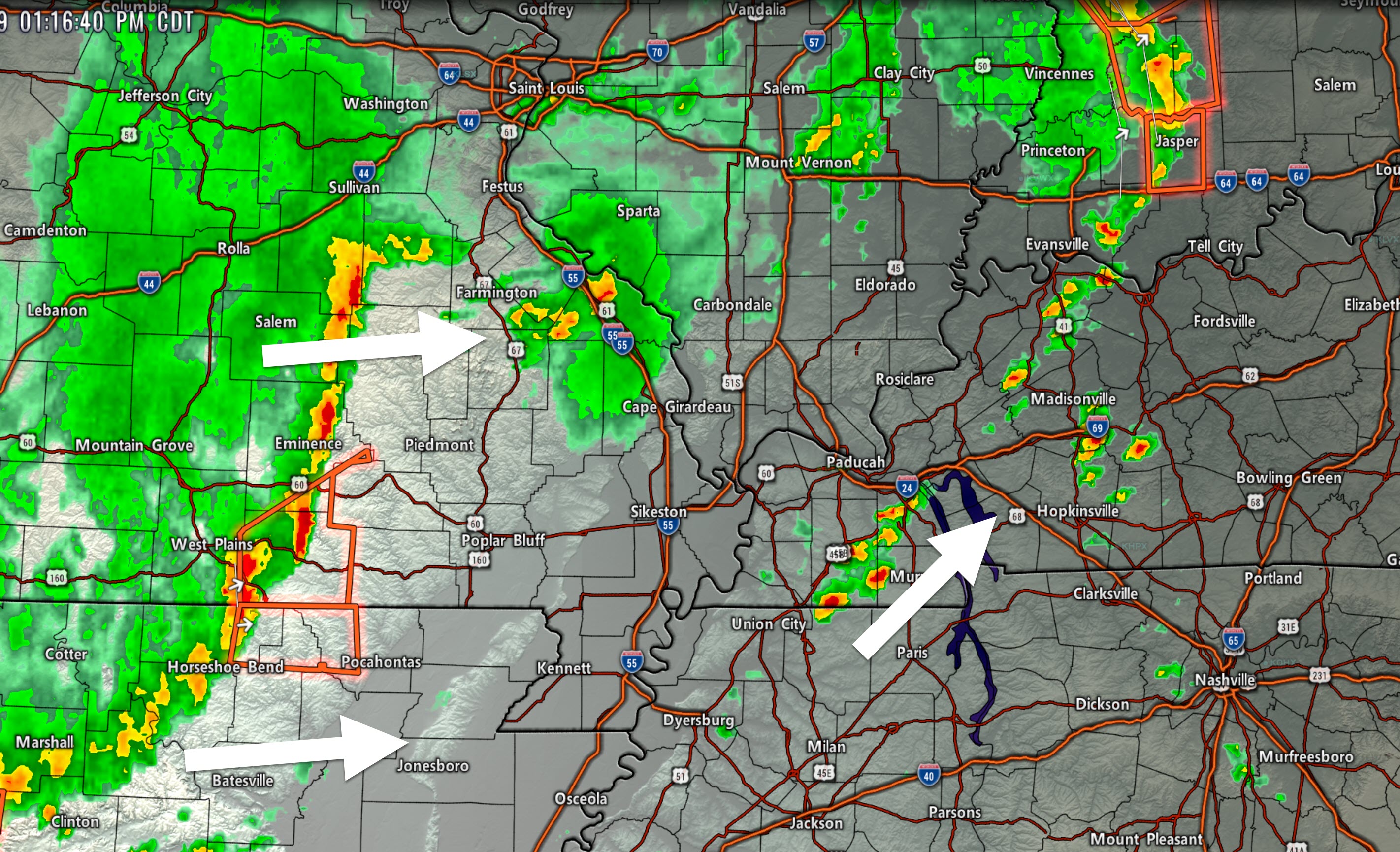
I continue to track a band of showers and thunderstorms as they move east and northeast out of southeast Missouri. They have been showing signs on intensifying.
Gusty winds and heavy rain. Lightning, of course.
LIVE Radar Link: Interactive local city-view radars & regional radars.
Static radar image.
Movement E NE at 40 mph.
.
8:30 AM Severe Weather Update
** Severe Thunderstorms Possible Again Today **
.
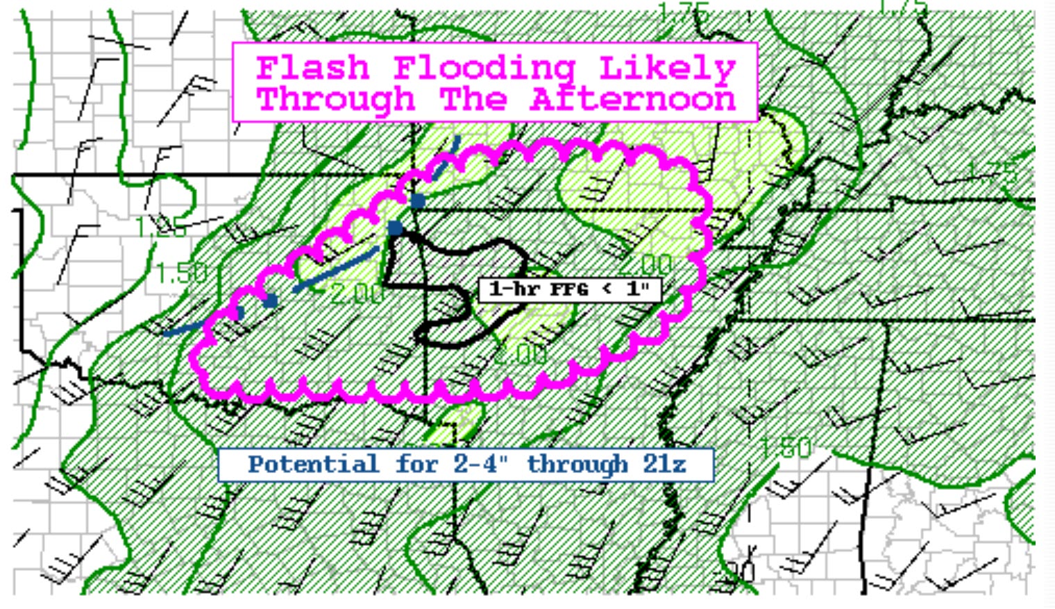
KEY MESSAGE
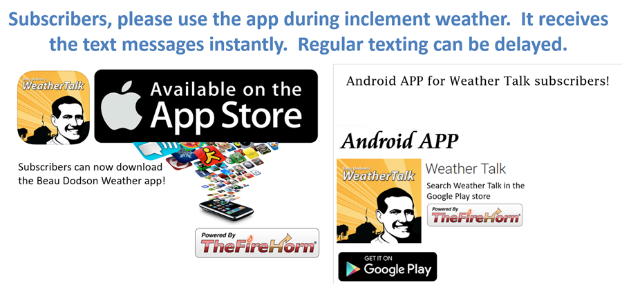
- Do not rely on the text messages. USE THE Beau Dodson Weather App. The app receives the same messages but instantly.
- Flash flooding is possible if storms train over the same area.
- A few storms today could produce wind damage, hail, torrential rain, and frequent lightning. The tornado risk is fairly low. It is never zero when you have severe thunderstorms.
- Today's severe weather event is highly dependent on clouds clearing and the atmosphere becoming a bit more unstable. Monitor updates.
.
Track the storms below.
LIVE Radar Link: Interactive local city-view radars & regional radars.
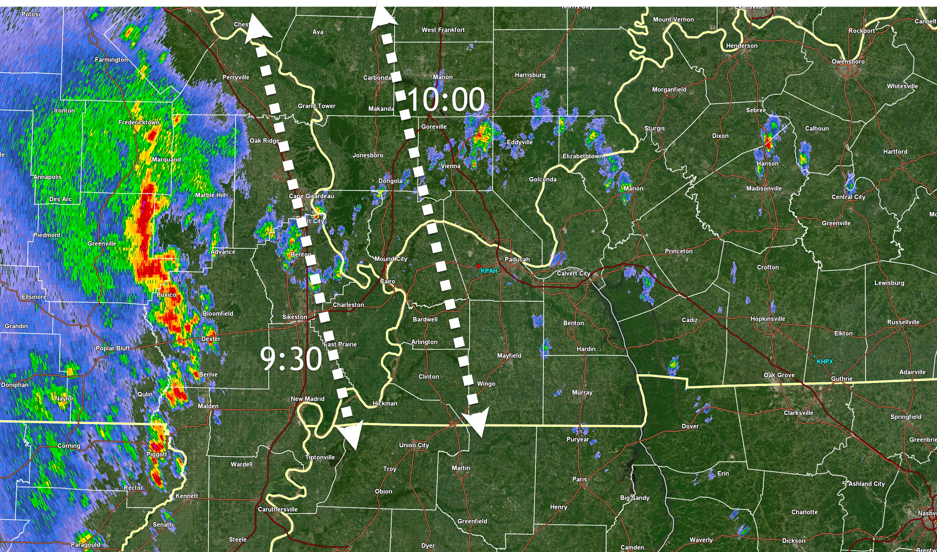
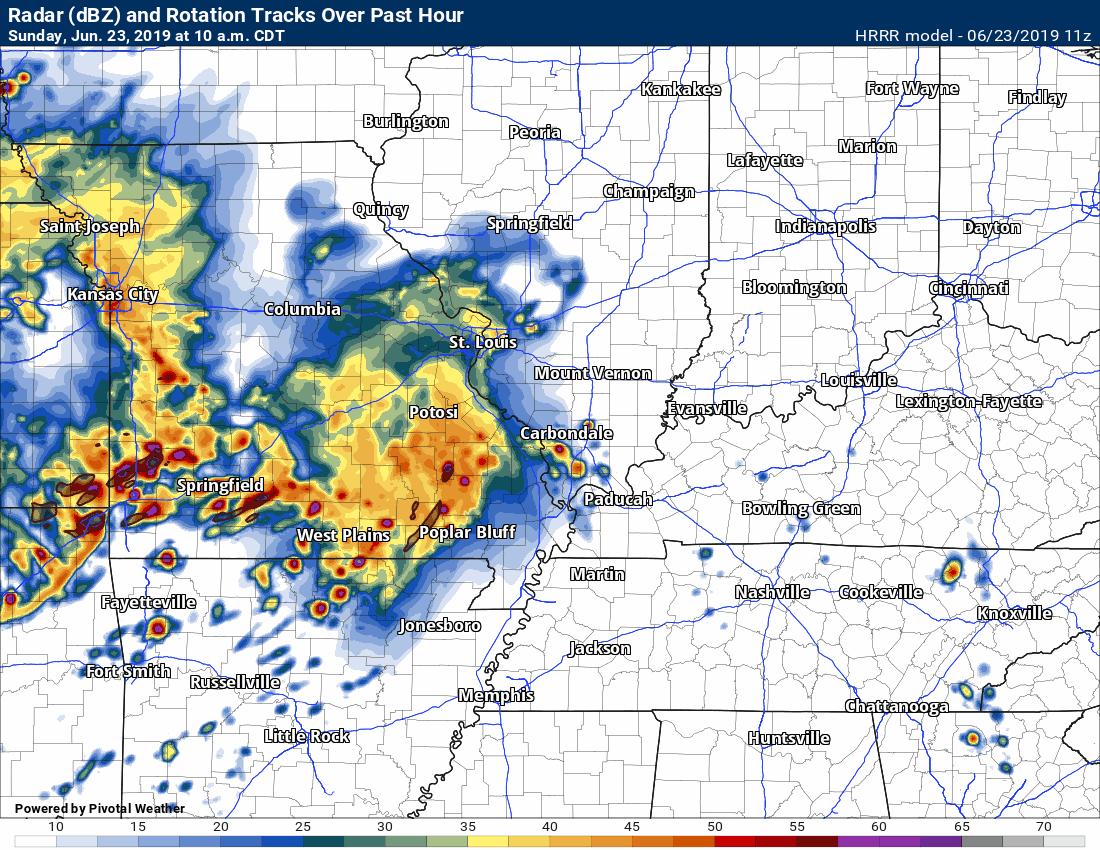
Here is a GIF that I made showing you the thunderstorm complexes moving east and northeast.
This animation ends around 8 AM. See the link above for fresh radar data.
Click the image to enlarge.
THIS IS NOT LIVE (see the LIVE radar link above)
.
Here is one of my radar software images.
You can see storms increasing in southeast Missouri.
These storms have been increasing in intensity. They are moving east/northeast at 40 mph.
.
Make sure that you have not logged out of your app, accidentally. Open your app. Make sure it is active and receiving data.
Speaking of the app, use the app and not the texts. Texts can be delayed by ATT and Verizon. The app is instant. Use the app.
We have more heavy thunderstorms in the forecast.
Remember, this is what the model believes will happen. Models are never exact.
.
.Monitor updates. I will be on top of the situation. I will be sending out app messages as necessary.
.
Let's take a look at a couple of maps.
Click images to enlarge them.
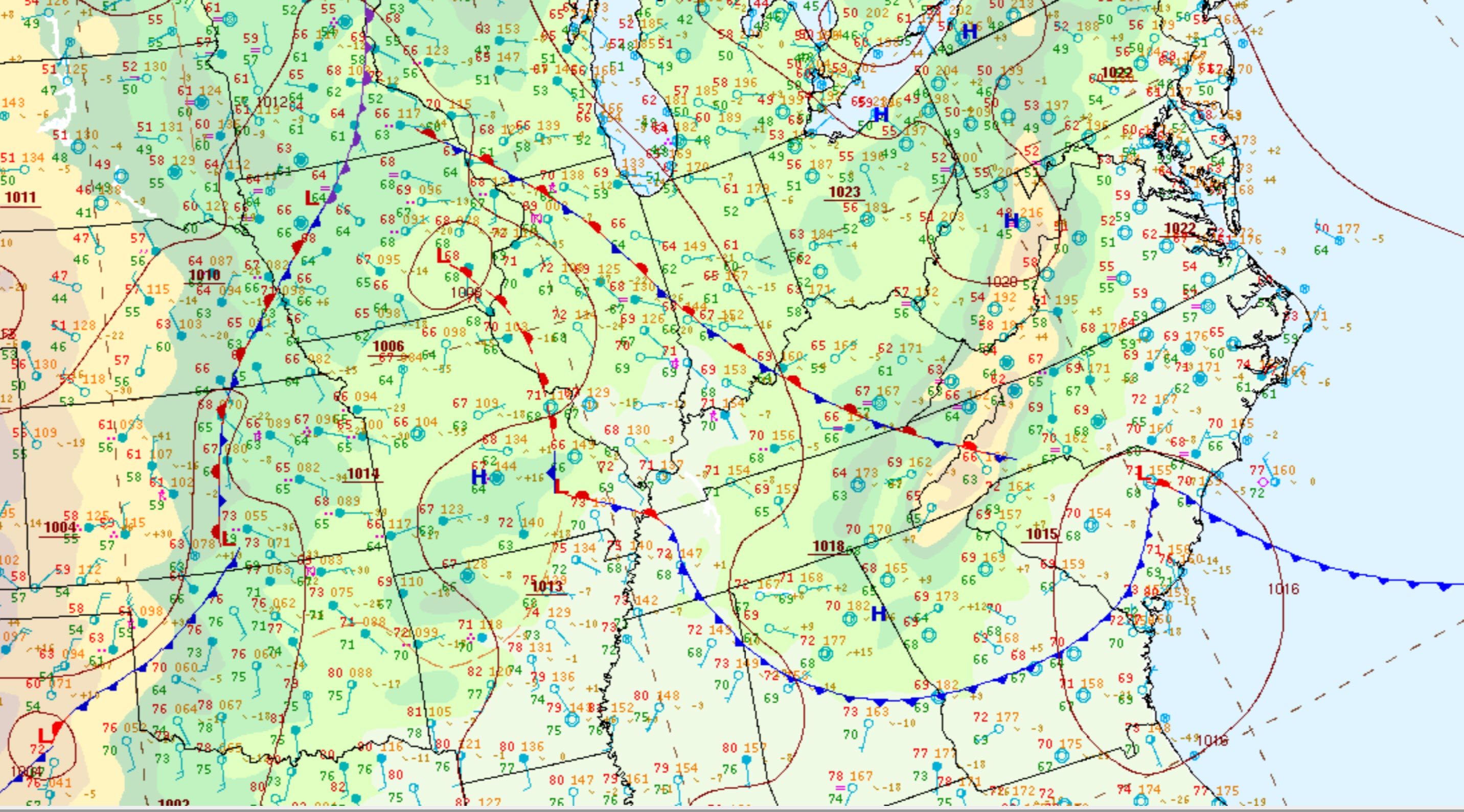
There is a stationary front draped across the region. Thunderstorm complexes (MCS's) are tracking along this front.
.
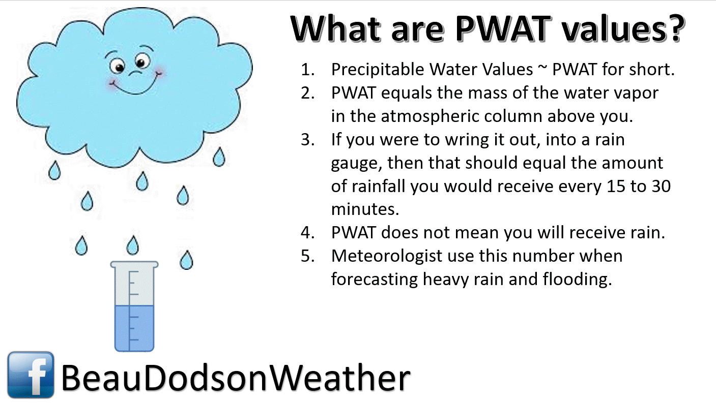
Click maps to enlarge.
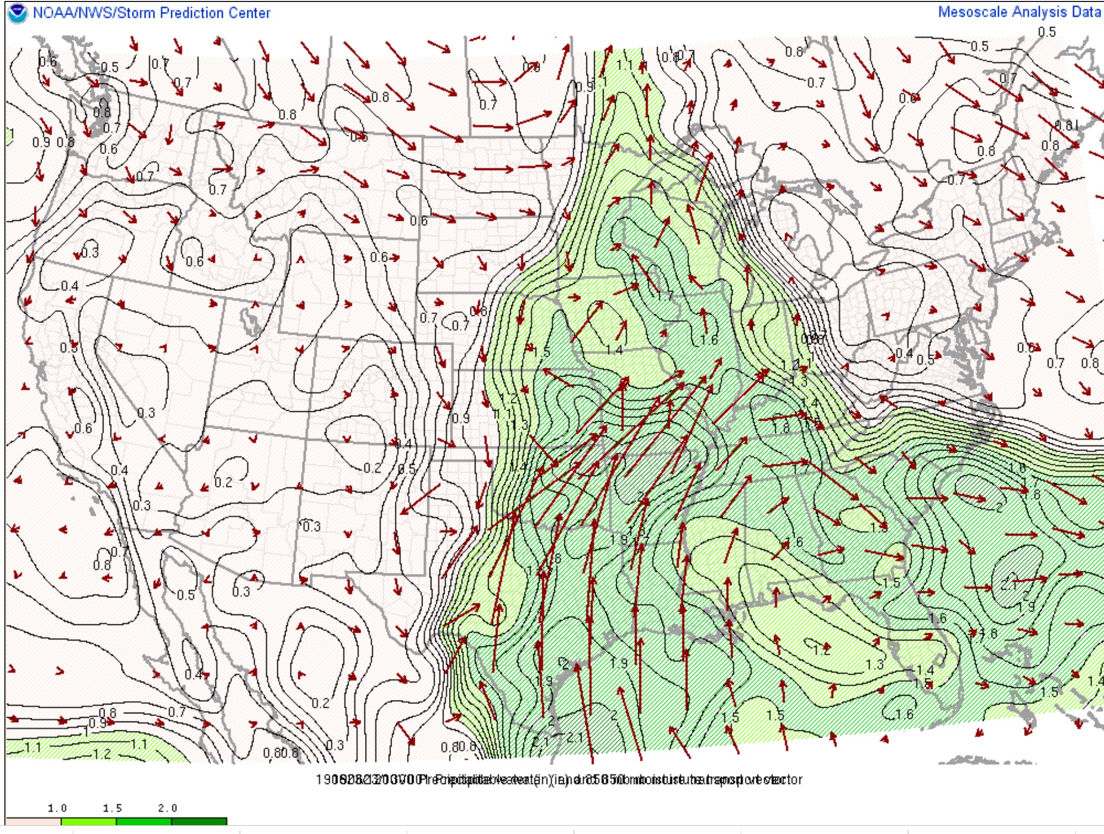
This is the PWAT value map. Very high numbers in the dark green zone.
.
National PWAT map. A lot of moisture.
.
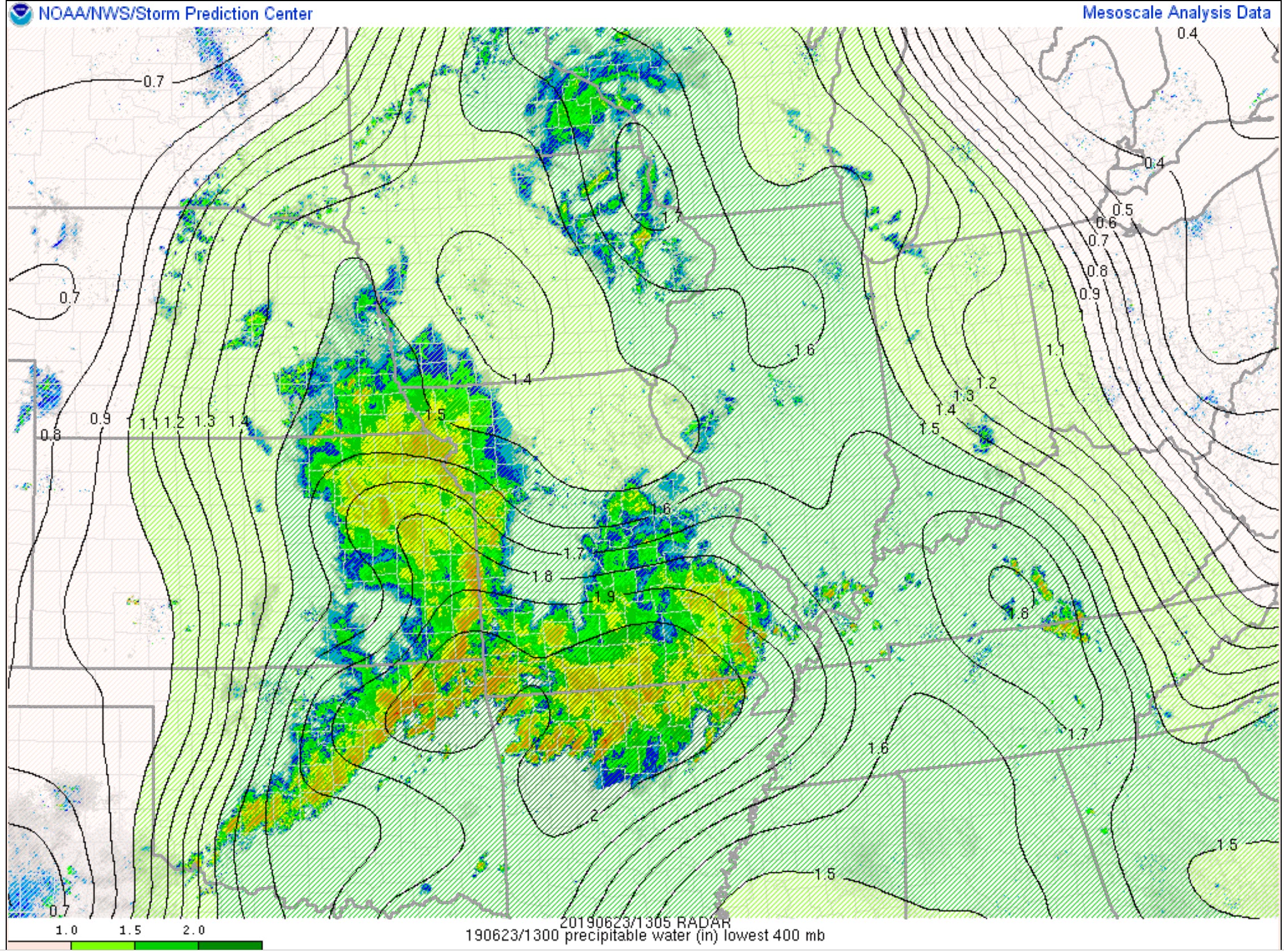
Another map showing you PWAT values.
Notice the pool of higher numbers of Arkansas and southern Missouri. Very high PWAT values. That means the risk of heavy rain is high.
Thunderstorms are prolific rain producers. This is a water pump.
The arrows show the source region. Air is moving from the south towards the north.
.
.
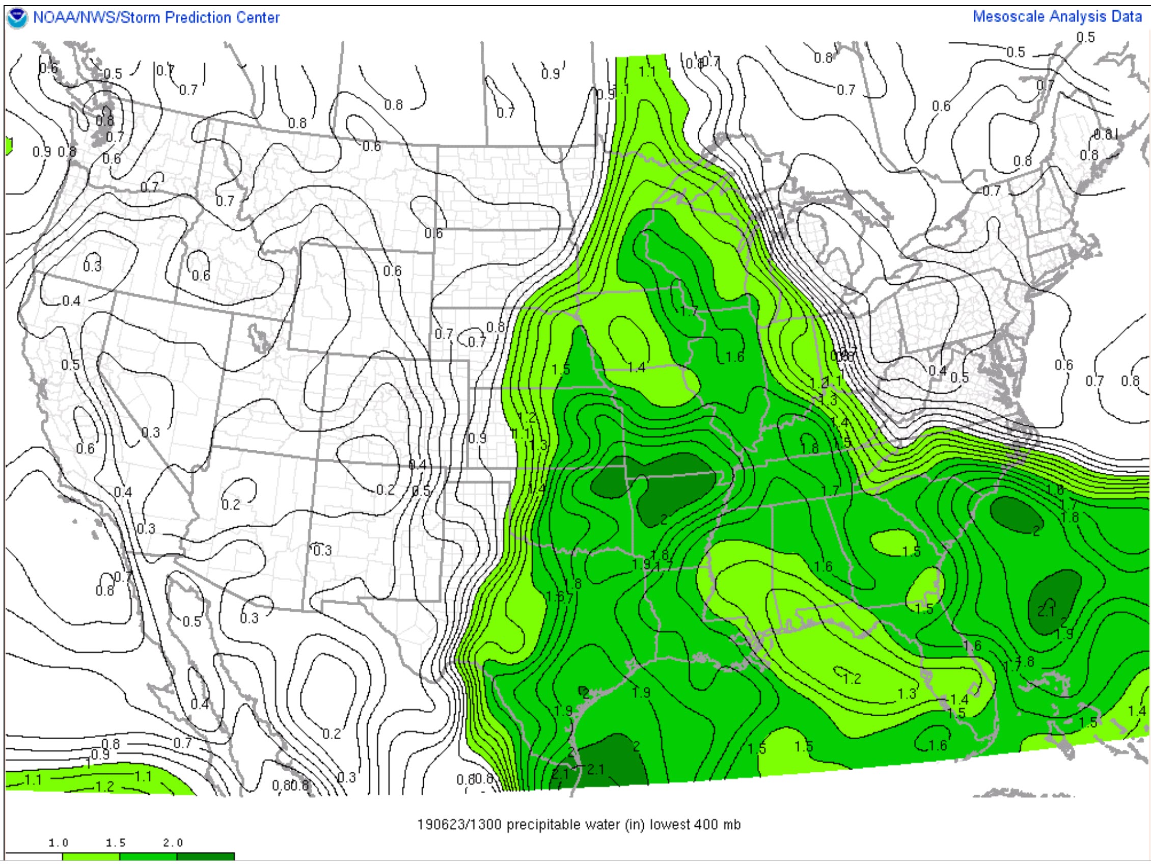
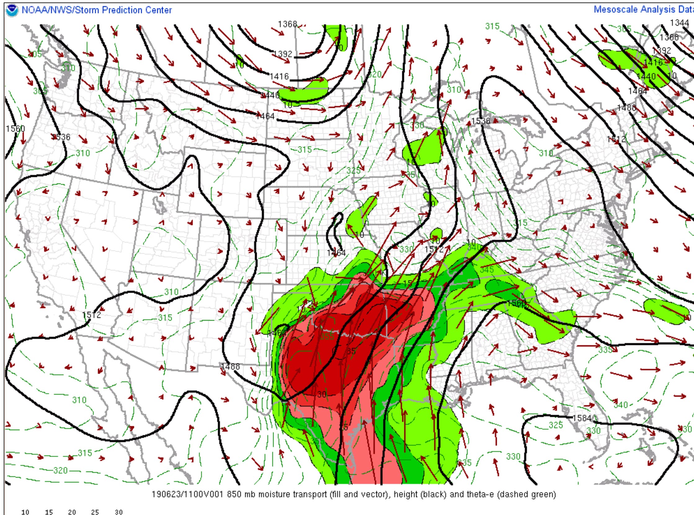
This map shows you moisture transport.
See the arrows? Where are the arrows coming from? The south. The source for all of this moisture.
.
We do have some CAPE this morning. A tongue of it from Illinois southward.
CAPE is a measure of instability/energy. Storms tap into the CAPE.
.
The pattern remains unchanged. Periodic episodes of showers and heavy thunderstorms. This is going to continue into next week.
PWAT values remain high. Today we are looking at PWAT values of 1.5 to 1.9". Those are tropical numbers. Just one more reason it feels so muggy outside.
High PWAT values are a signal for torrential tropical-like downpours. You can pick up 1" to 2" of rain in an hour. If a couple of thunderstorms train over the same area then flash flooding occurs.
.
.
PWAT's. Check out the source region. The Carribean, Gulf of Mexico, Atlantic Ocean.
.
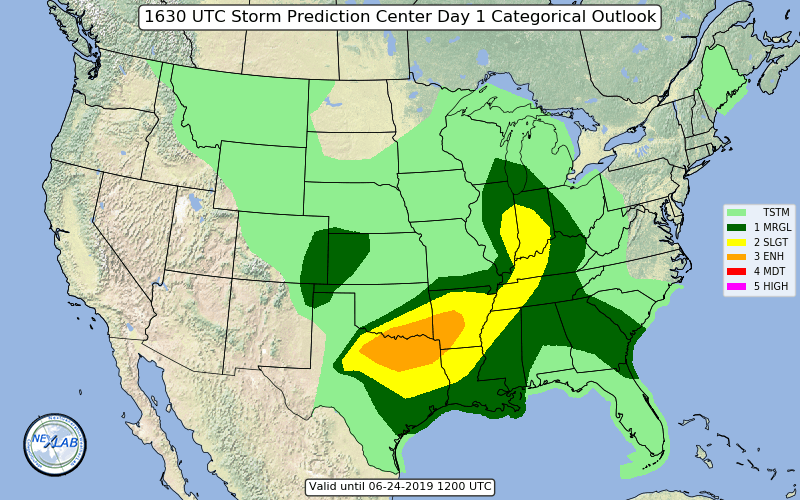
Today's SPC severe weather outlook (below).
Light green is where thunderstorms may occur but should be below severe levels.
Dark green is a level one risk. Yellow is a level two risk. Orange is a level three (enhanced) risk. Red is a level four (moderate) risk. Pink is a level five (high) risk.
One is the lowest risk. Five is the highest risk.
Light green is not assigned a number. Light green is where storms may occur but should be below severe levels.
A severe storm is one that produces 60 mph winds or higher, quarter size hail, and/or a tornado. One or more of those is defined as a severe thunderstorm.
.

.
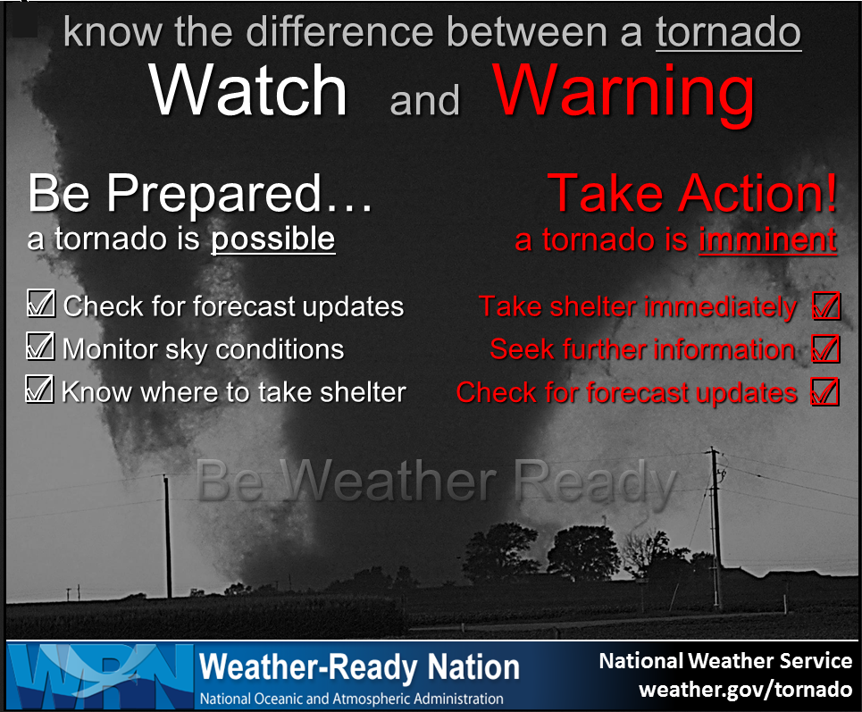
Remember, a watch means to go about your business and monitor updates. A warning means to move to a safe place of shelter until the storm passes.
.
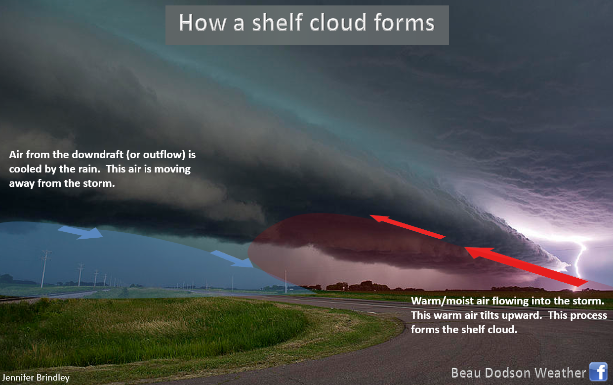
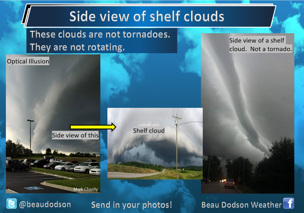
You will likely see a lot of shelf clouds today.
.
Additional storm tracking quick links
STORM TRACKING TOOLS
Interactive city-view radars
http://weatherobservatory.com/weather-radar.htm
Clickable watches and warnings can be viewed on the local city-view interactive radars (link above). Be sure and turn on the warnings above the local radars.
A new regional radar we offer
https://imagery.weathertalk.com/prx/RadarLoop.mp4
Lightning data
https://wtalk.co/7QT7WHKU
Watches/warnings
https://imagery.weathertalk.com/prx/SevereAlerts.png
Infrared satellite
https://imagery.weathertalk.com/prx/IRSatelliteLoop.mp4
Visible satellite
https://imagery.weathertalk.com/prx/GeocolorSatelliteLoop.mp4
Current conditions
https://imagery.weathertalk.com/prx/CurrentConditions.png
Current heat index or wind chill
https://imagery.weathertalk.com/prx/CurrentFeelsLike.png
Wind speed
https://imagery.weathertalk.com/prx/CurrentWindSpeed.png
Wind gust
https://imagery.weathertalk.com/prx/CurrentWindGust.png
Beau Dodson Weather App!
Have you downloaded the Beau Dodson Weather app?
Move to the app and do not depend on the text messages. The app receives the exact same messages but faster.
ATT and Verizon have been throttling the speed of texts.
The app receives them instantly.
Apple users: Beau Dodson Weather App
https://itunes.apple.com/us/app/id1190136514
Android users: Beau Dodson Weather App
https://play.google.com/store/apps/details?id=com.weathertalk.beaudodsonweather.android
.
Today's SPC severe weather outlook (below).
Light green is where thunderstorms may occur but should be below severe levels.
Dark green is a level one risk. Yellow is a level two risk. Orange is a level three (enhanced) risk. Red is a level four (moderate) risk. Pink is a level five (high) risk.
One is the lowest risk. Five is the highest risk.
Light green is not assigned a number. Light green is where storms may occur but should be below severe levels.
A severe storm is one that produces 60 mph winds or higher, quarter size hail, and/or a tornado. One or more of those is defined as a severe thunderstorm.

The black outline is our local area.
.
Not receiving app/text messages?
Make sure you have the correct app/text options turned on. Find those under the personal notification settings tab at www.weathertalk.com. Red is off. Green is on.
Subscribers, PLEASE USE THE APP. ATT and Verizon are not reliable during severe weather. They are delaying text messages.
The app is under Beau Dodson Weather in the app store.

Apple users click here

Android users click here
.
.

.
.
Today's outlook (below).
Light green is where thunderstorms may occur but should be below severe levels.
Dark green is a level one risk. Yellow is a level two risk. Orange is a level three (enhanced) risk. Red is a level four (moderate) risk. Pink is a level five (high) risk.
One is the lowest risk. Five is the highest risk.
Light green is not assigned a number. Light green is where storms may occur but should be below severe levels.
A severe storm is one that produces 60 mph winds or higher, quarter size hail, and/or a tornado. One or more of those is defined as a severe thunderstorm.
The black outline is our local area.
.
Tomorrow's outlook.
Light green is where thunderstorms may occur but should be below severe levels.
Dark green is a level one risk. Yellow is a level two risk. Orange is a level three (enhanced) risk. Red is a level four (moderate) risk. Pink is a level five (high) risk.
One is the lowest risk. Five is the highest risk. Light green is not assigned a number.


.
.
Here is the latest graphic from the WPC/NOAA.
24-hour precipitation outlook.
.

.
48-hour precipitation outlook.
.
.
.
72-hour precipitation outlook.
.

.
Days one through seven added together. Seven-day rainfall totals.

.
Radar Link: Interactive local city-view radars & regional radars.
You will find clickable warning and advisory buttons on the local city-view radars.
If the radar is not updating then try another one. If a radar does not appear to be refreshing then hit Ctrl F5. You may also try restarting your browser.
Not working? Email me at beaudodson@usawx.com
National map of weather watches and warnings. Click here.
Storm Prediction Center. Click here.
Weather Prediction Center. Click here.
.
Live lightning data: Click here.
.

Interactive GOES R satellite. Track clouds. Click here.
GOES 16 slider tool. Click here.
College of Dupage satellites. Click here
.

Here are the latest local river stage forecast numbers Click Here.
Here are the latest lake stage forecast numbers for Kentucky Lake and Lake Barkley Click Here.
.
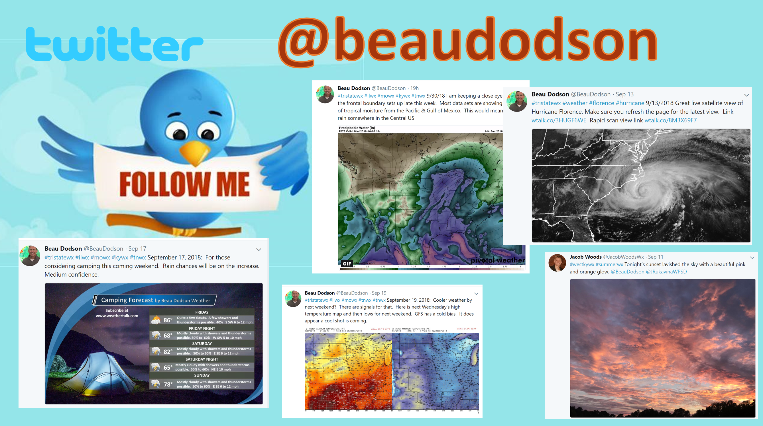
Did you know that you can find me on Twitter? Click here to view my Twitter weather account.
.

.
Who do you trust for your weather information and who holds them accountable?
I have studied the weather in our region since the late 1970s. I have 40 years of experience in observing our regions weather patterns.
My degree is in Broadcast Meteorology from Mississippi State University and a Bachelor of Science (BS).
I am an NOAA Weather-Ready Nation Ambassador. I am the Meteorologist for McCracken County rescue squad. When asked, I assist Ballard and Massac Counties, as well.
I own and operate the Southern Illinois Weather Observatory and WeatherTalk LLC.
There is a lot of noise on the internet. Over time you should learn who to trust for your weather information.
My forecast philosophy is simple and straight forward.
- Communicate in simple terms
- To be as accurate as possible within a reasonable time frame before an event
- Interact with you on Twitter, Facebook, and the blog
- Minimize the “hype” that you might see on television or through other weather sources
- Push you towards utilizing wall-to-wall LOCAL TV coverage during severe weather events
I am a recipient of the Mark Trail Award, WPSD Six Who Make A Difference Award, Kentucky Colonel, and the Caesar J. Fiamma” Award from the American Red Cross.
In 2009 I was presented with the Kentucky Office of Highway Safety Award.
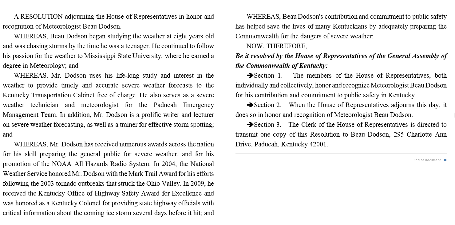
I was recognized by the Kentucky House of Representatives for my service to the State of Kentucky leading up to several winter storms and severe weather outbreaks.
If you click on the image below you can read the Kentucky House of Representatives Resolution.
.
.
Previous episodes can be viewed by clicking here.
.
Find Beau on Facebook! Click the banner.

.
Find Beau on Twitter! Share your weather photos! @beaudodson

.
Did you know that a portion of your monthly subscription helps support local charity projects? Not a subscriber? Becoming one at www.weathertalk.com
You can learn more about those projects by visiting the Shadow Angel Foundation website and the Beau Dodson News website.